
Powerful Hurricane Dorian devastating Bahamas
Hurricane Dorian is causing destructive weather in the Bahamas and could affect the southeastern United States later this week.
Hurricane Dorian made landfall over the Great Abaco Island in the northern Bahamas on Sunday. At the time of landfall, Dorian was a chart-topping category five major hurricane, with one-minute sustained wind speeds of 295km/h (185mph) near its core. This made Dorian the equal strongest hurricane on record to make landfall in the Atlantic Basin and the strongest to strike the Bahamas.
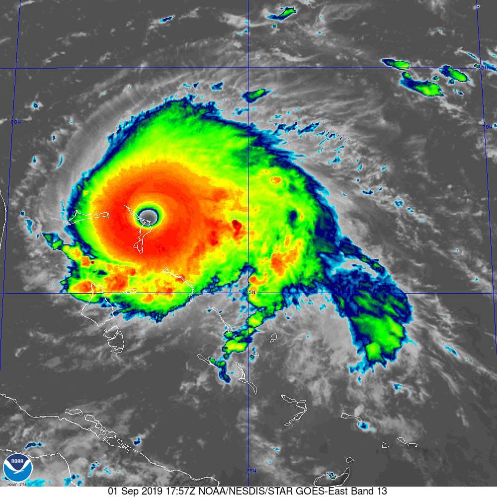
Image: Hurricane Dorian making landfall in the Bahamas on Sunday, September 1st 2019. Source: NOAA/NHC
Hurricane Dorian is expected to continue moving across the northwest Bahamas on Sunday and Monday, moving from the Abaco islands to the Grand Bahama. Unfortunately, a weak flow of steering winds in the atmosphere means that Dorian's destructive weather - which includes wind, rain and storm surges - will continue to devastate the Bahamas for a prolonged period of time.
Dorian is expected to turn towards the north from Tuesday and move roughly parallel to Florida's east coast during the middle of the week. The system should be close enough to Florida to cause a storm surge and hurricane force winds in the state's east. Given the dynamic nature of hurricanes, landfall in eastern Florida also can't be ruled out during the middle of the week.
Current forecast models suggest that Dorian will continue to move up towards Georgia and the Carolinas between Wednesday and Friday, most likely staying offshore but possibly nearing or even crossing the coast.
The sun set on #HurricaneDorian as it battered the #Abaco and #GrandBahama islands with wind gusts of more than 220 mph today. NOAA's #GOESEast continues to keep watch over the slowing catastrophic Cat. 5 storm. Latest updates: https://t.co/ScLdyBac9D pic.twitter.com/teqJo1RT1k
— NOAA Satellites (@NOAASatellites) September 2, 2019
In recent years, it's taken hours or even days for accurate weather observations, reliable damage reports and images to become available following the coastal crossing of a powerful hurricane like Dorian. Today, we have access to a plethora of imagery and data in real-time, even while the eye of the hurricane continues to batter the Bahamas.
One of the more fascinating sources of data and imagery comes from a fleet of aircraft that have been flying into the eye of Hurricane Dorian during the last several days.
The eye of #Dorian pic.twitter.com/XN29zC46IP
— Garrett Black (@GBlack22wx) September 1, 2019
These aircraft, known as the Hurricane Hunters, collect valuable weather observations from the sky and oceans surrounding hurricanes to help forecasters accurately predict their future movement.
Forecasting hurricanes, tropical cyclones and typhoons (which are all the same type of weather system) is notoriously difficult. However, improvements in numerical weather prediction computer models and an ever-increasing network of observations is making this task progressively easier and more accurate.
Incredible to think there is a category 5 hurricane less than 200 miles east of me, and the threat from #Dorian is judged to be low enough that there’s no warning in place for #Miami. We live in amazing scientific times! pic.twitter.com/VgX3m9kSZQ
— Eric Blake 🌀 (@EricBlake12) September 1, 2019
The latest hurricane advisories for Dorian are available on the U.S. National Hurricane Centre's website here: https://www.nhc.noaa.gov/