
Potential nor'easter to slam U.S. East Coast this weekend
A nor’easter could cause dangerous weather along the East Coast of the United State this weekend into early next week.
This system has the potential produce over 2-3 inches of rain across coastal areas of the Carolinas northward into southern New England. In addition to pockets of heavy rainfall, strong winds from the north or northeast will also batter coastal areas as wind gusts could exceed 40-50 mph in some areas.
What is a nor’easter?
Nor’easters are a type of storm system that will typically form along the East Coast of North America, with the strongest winds typically blowing from the northeast. These storms are most common in early fall through late spring.
During the winter months, nor’easters can dump over a foot of snow to locations further inland across the Mid-Atlantic and Northeast, along with heavy rain and strong winds near the coast. It’s not uncommon for these storms to cause widespread power outages and major travel disruptions.
How will this weekend’s nor’easter develop?
An upper-air trough is expected to build across the Southeast U.S. around Thursday and Friday this week, while a low pressure system near the surface will consolidate off eastern Florida and southeast Georgia on Friday and Saturday.
This low pressure system will drift north towards the coastal Carolinas throughout the weekend before heading further north towards the Mid-Atlantic and southern New England on Sunday into Monday.
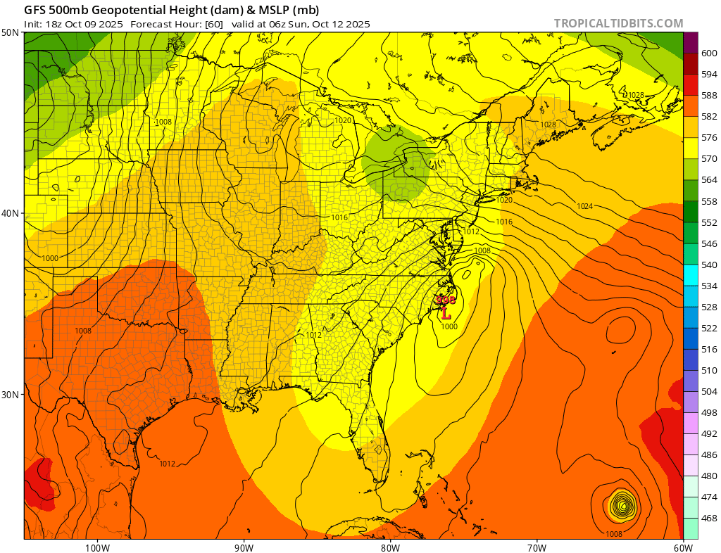
Image: Forecast 500mb geopotential height and mean sea level pressure, showing an upper-air trough over the Southeast U.S. and a surface-based low pressure system near the North Carolina coast early on Sunday morning. Source: TropicalTidbits.com
There is currently some uncertainty regarding the strength of the nor’easter once it reaches southern New England.
One important feature to watch will be a secondary upper-air disturbance shifting through the Great Lakes later this week, which could significantly strengthen the nor'easter and allow stronger winds and heavier rain to develop in the Mid-Atlantic and southern New England from Sunday into early next week.
High pressure ridges over the central U.S. and southeast Canadia should drive the nor'easter offshore from around Tuesday, allowing wind and rain to finally subside across New England going into the middle of next week.
Potential impacts from this nor’easter
Strong winds, heavy rain, and coastal impacts will likely be the main risks with this storm. Weather impacts could stretch from the eastern Carolinas into southern Vermont and New Hampshire, impacting millions of people.
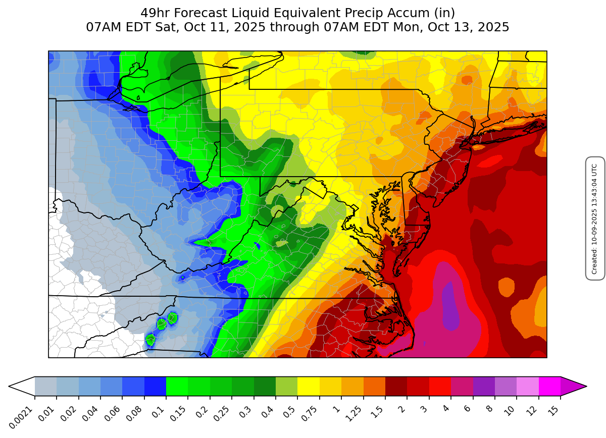
Image: Forecast rainfall across the Mid-Atlantic Saturday morning through Monday morning shows at least 2-3 inches falling across coastal areas. Source: DTN
If this system can strengthen over the weekend, the Outer Banks of North Carolina could see easterly or northeasterly wind gusts approach 40 mph. By late this weekend, the Delmarva Peninsula could be dealing with northeasterly or northerly sustained winds around 20-30 mph while gusts reach as high as 40-50 mph. Sunday into Monday appears to be when the strongest winds will tag New England as wind gusts could reach over 50 mph along eastern Long Island and Cape Cod in Massachusetts.
Along with the strong winds comes a risk of beach erosion and coastal flooding as large waves could come crashing onshore with the strong northeasterly winds. Significant wave heights could reach over 10-15 feet near the shores of southern Long Island and eastern New Jersey this weekend.
Rainfall along parts of the East Coast could be heavy as well. Eastern North Carolina and the Delmarva Peninsula could see at least two inches of rain in some spots with locally higher amounts near 3-4 inches. By the time the system reaches southern New England, heavy rainfall does not look nearly as widespread, but there is still a moderate risk that rainfall totals could reach up to two inches across eastern Massachusetts.
Be sure to stay up to date with the latest warnings in your area if you’re in the East Coast this weekend into early next week.