
Perth storms drench some suburbs, leave others bone dry
The heavy rain that Perth residents are so desperately hoping for drenched some northern suburbs on Friday afternoon, but ultimately fizzled out in most parts of the city, delivering just 1.2 mm to the city's official weather station, while numerous locations in and around the metropolitan area missed out altogether.
After Perth's driest six-month period in 148 years of records from the beginning of October through to the end of March, April had been totally rainless across the city until late afternoon on Friday, April 12.
While the Weatherzone radar tantalisingly showed showers within a close coo-ee of the CBD, the heaviest rain stayed just north of the city, with flash flooding and unconfirmed reports of up to 100 mm in some suburbs while in suburbs further south the ground barely got wet.
HAPPENING NOW: The drought has been broken for some of Perth’s northern suburbs, with heavy rain and hail after months of dry weather. ????? #9News pic.twitter.com/Mj6hpJHYLt
— 9News Perth (@9NewsPerth) April 12, 2024
As Weatherzone meteorologist Brett Dutschke wrote on Saturday, for the areas that did get wet on Friday, it was the first rain in:
- Twelve weeks at Rottnest Island (just 0.2mm)
- Seven weeks at Swanbourne (1.0mm)
- Six weeks at Arena (0.8mm), Jurien Bay (4.6mm), Geraldton (0.6mm), Coolangatta (14mm), Badgingarra (4mm), and Gingin 16.4 mm
- Five weeks in Perth’s Mt Lawley (1.2mm), Jandakot (9.2mm), Jarrahdale (3.8mm), Pearce (11.2mm), Bickley (4.0mm) and Anketell (10.3mm)
But overall, this was far from the significant rain even the entire southwest of WA needs, and regrettably, no such event looms on the immediate horizon.
READ MORE: Desperately dry in southwest WA
As any local knows, cold fronts which arise in the southern Indian Ocean usually produce the heaviest rainfall for the southwest, however such systems are still being blocked by unusually strong and persistent highs centred south of the continent.
Indeed the airmass that produced the outburst of storms on Friday had tropical origins, and no moisture at all made it to coastal districts south of Perth.
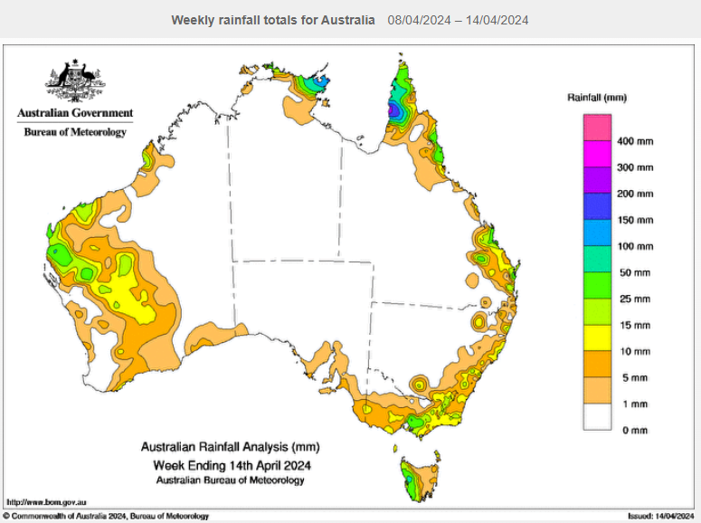
Source: BoM.
The image above shows rainfall for the week up to Sunday, April 14. It paints a familiar picture for the first few months of 2024, with rain in inland areas but nothing in the southwest.
We wrote recently about how Busselton had seen less than one millimetre of rain in 2024 to date and that is still true for the town two hours south of Perth, which is the gateway to the Margaret River surf and wine region.
READ MORE: Jarrah trees dying in WA's big dry
Meanwhile another dry week looms ahead for Perth and the southwest, and this one promises to be warmer than last week, when Perth maximums were in the mid-to high twenties from Monday through to Sunday. This week, Perth should top 30°C from Tuesday through to Sunday, reaching 34°C on Thursday.
That’s far from record-setting territory – Perth's highest April temp was 39.5°C in 2020 – but it’s still well above the average April max of 25.9°C. More to the point, such warm temperatures at this time of year are almost invariably associated with the likelihood of dry weather.