
Pacific El Niño and rare ‘Atlantic Niña’ – what this means for Atlantic Hurricane Season
Lots of attention is focused on a strengthening El Niño in the tropical Pacific this year, with good reason. But there is a less-known oceanic temperature feature emerging in the Atlantic Ocean that will have an influence on the hurricane season: an Atlantic Niña.
Cooling in the Equatorial Atlantic
The tropical Pacific has ENSO, the El Niño Southern Oscillation, which swings periodically between the warm phase of sea surface temperatures, El Niño, and the cooler phase, La Niña.
Similarly, a so-called ‘Atlantic Niña’ is the cooler phase of a natural climate pattern called the Atlantic Zonal Mode (with ‘zonal’ simply meaning ‘along lines of latitude’). It tends to peak in July and August, though, which is earlier than a typical Pacific El Niño or La Niña, and it works on a smaller scale and less frequently. In the past forty years there have been just five examples of this phenomenon, so it’s notable when it appears.
Trade Winds and Upwelling Water
Much of the North Atlantic has been warmer than average for a long time but a strip of cooler-than-average water has appeared in the tropics over the past month. This cool strip is due to an increase in southeast to easterly trade winds, which have led to an upward motion of colder water from the depths off the coast of equatorial Africa (called equatorial upwelling). These cooler surface waters then get transported westwards from around the Gulf of Guinea and the western tropical Atlantic.
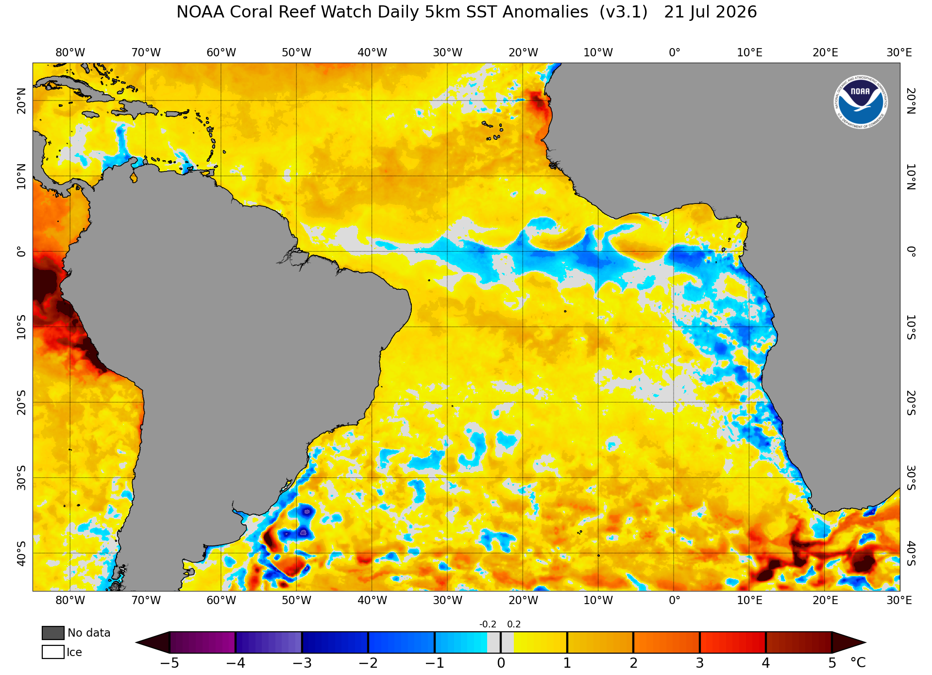
Image: Sea surface temperature anomalies in the tropical Atlantic Ocean on July 21, 2026, showing an Atlantic Niña pattern. Source NOAA.
El Niño and Atlantic Niña in Partnership
Having an Atlantic La Niña develop while a strong El Niño emerges to the west may seem like a conflict, as the former brings cooler-than-normal sea surface temperatures to the equatorial Atlantic, while the latter is associated with anomalously warm waters in the tropical Pacific. However, both climate patterns have similar impacts, particularly on the Atlantic hurricane season.
During a warm phase of the Atlantic Zonal Mode, the Atlantic Niño, there is more fuel and energy to instigate tropical developments, while the opposite is true during the cooler episodes of an Atlantic Niña. Meanwhile, El Niño in the Pacific causes an increase in wind shear (change in wind speed or direction with height) across the North Atlantic, which can tear apart nascent storm circulations, which typically suppresses hurricane activity.
Suppressed Development
Even in isolation, an Atlantic Niña year has been shown to reduce the number of tropical cyclones by 50% compared to the warm phase. But when allied with enhanced wind shear and sinking air across the tropical Atlantic from El Niño, this should lead to subdued tropical storm activity. This is reflected by NOAA's prediction of 8-14 named storms in the 2026 Atlantic hurricane season, which is a below-average number.
It will be interesting to monitor this Atlantic Niña alongside the increasingly strong El Niño, and whether this uncommon combination has an even greater dampening effect on hurricane development this year.
It’s also worth noting that even during a relatively quiet year, there can still be powerful hurricanes. For example, 1992 was an El Niño year that had suppressed numbers but that did not prevent the destruction of Category 5 Hurricane Andrew.
The Atlantic Hurricane season officially runs from June to November. You can find the latest hurricane advisories on the National Hurricane Centre website throughout season.