
One year on from the Guadalupe River flash flood – how predictions are improving
It has been one year since devastating flooding in the Guadalupe River claimed the lives of 119 people in Kerr County, Texas.
The summer of 2025 started with a series of flash flood events across the United States. The most impactful flood occurred on July 4, 2025, in the Guadalupe River.
What caused the Guadalupe River flood?
Several weather factors played a part in how this flash flood event unfolded.
On July 3, 2025 the U.S. Drought Monitor reported that much of Kerr County was in an exceptional drought. Thus, when heavy rainfall started it was difficult for the hardened soil to absorb precipitation and it ended up rushing directly into creeks and tributaries feeding the Guadalupe River.
There was also an abundance of tropical moisture moving over the region. This was due to the remnants of Tropical Storm Barry moving over Texas, combining with a tropical wave over the western Bay of Campeche and Tropical Storm Flossie over the east Pacific.
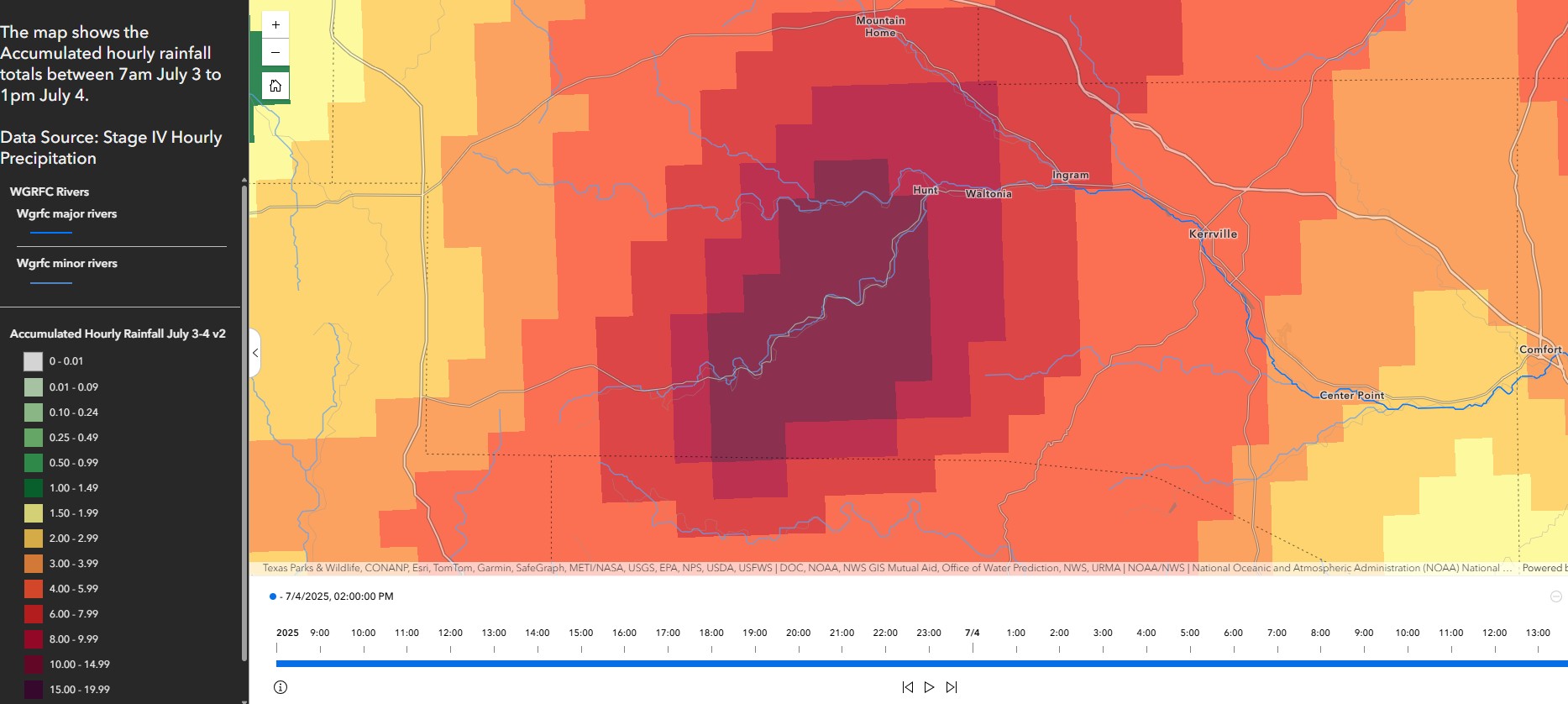
Image: Accumulated hourly rainfall totals between 7 am July 3 and 1 pm July 4, 2025. Source: NOAA/NWS – Stage IV Hourly Precipitation
This unique weather pattern made Kerr County and other areas over the Texas Hill Country vulnerable to heavy rainfall and flash flooding.
A band of heavy rain moved over the area producing 7-12 inches with most of this falling within 3 hours. Rainfall rates were recorded as high as 5.22 inches per hour at a rain gauge along the South Fork of the Guadalupe River, about six miles southwest of Hunt, TX. Data analysis showed that based on the 3-hour observed rainfall over the area this was a 1-in-1000-year flood event. Put another way, there is a 0.1% chance of this occurring in any given year.
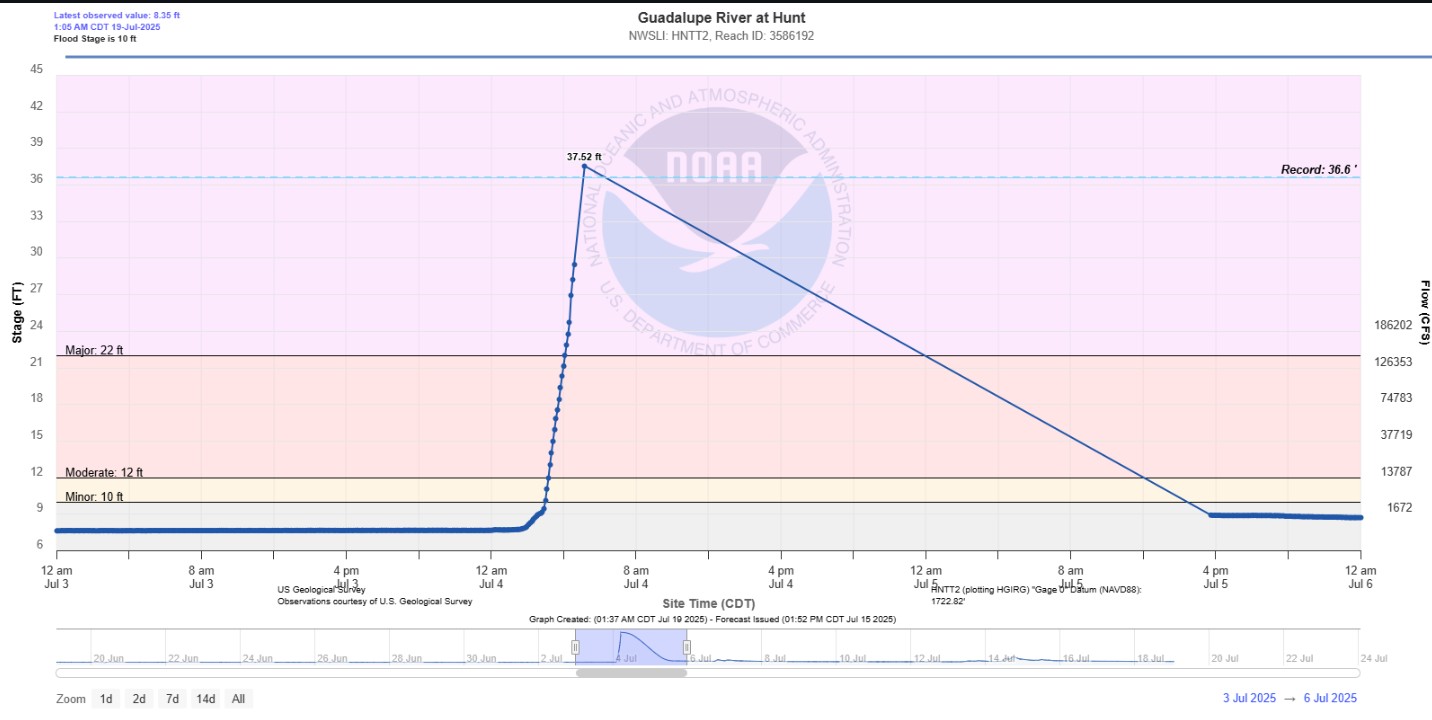
Image: Observed hydrograph data of the Guadalupe River Crest at Hunt, TX at around 4am CDT on July 4, 2025. Source: NOAA River Rain Gauge
Predicting flash floods
Flash floods are one of the deadliest weather hazards in the U.S.; the national 30-year average for flood deaths is 88. By comparison, the 30-year average for lightning deaths is 41 and for tornadoes is 68, according to NOAA.
Flash floods are also one of the hardest severe storm hazards to predict. Researchers at the National Severe Storms Laboratory (NSSL) are working on ways to improve predicting exactly where the most intense rainfall rates will occur during convective storm events.
Supercells or thunderstorms that train over the same area repeatedly are two types of weather patterns that often cause flash flooding. This makes it crucial to be able to forecast where a thunderstorm will develop, its intensity, and its type. The slightest shift of even just a few miles in where heaviest precipitation will fall can make a big difference to the flooding risk.
One tool that NSSL has developed to help with this issue is the Multi-Radar Multi-Sensor (MRMS) system. The MRMS is a product that combines raw data from weather radars, rain gauges, satellites, and numerical models into one high-resolution image.
The next thing to understand is how the water will move once it hits the ground. NSSL researchers have also created FLASH (Flooded Locations And Simulated Hydrographs Project), a suite of products that translates MRMS rainfall data into runoff predictions using physics-based modeling.
he NSSL is using advances in computing, AI, and machine learning to produce multiple storm scenarios in the Warn-on-Forecast System (WoFS). This system is capable of producing severe storm outputs several hours in the future with those scenarios run through hydrologic models to better predict where flooding may develop. It is NOAA and NSSL’s mission to continue to find ways to prevent this kind of loss of life.