
New Year arctic blast looms for UK
As the start of the New Year approaches, it looks set to turn bitterly cold across the UK as an Arctic airmass begins to spread south. This is in stark contrast to 2025 which was one of the warmest years on record for the UK.
Cold end to a warm year in the UK
December was notably wet and mild for the UK, but this came to an end a couple of days before Christmas as high pressure moved overhead, bringing more settled weather for the festive period, albeit with a drop in temperatures.
This drier weather was welcomed by many but, with colder weather in place, some may have been hoping for a White Christmas. This was achieved nearby in Jersey but no snow fell over the UK. Instead, dry and sunny weather prevailed for many on Christmas Day.
As of just before Christmas, the UK’s mean annual temperature for 2025 was running well above 10°C and could break the record of 10.03°C from 2023. However, as temperatures dropped in the last week of December, the final placing is yet to be confirmed.
2025 has also already been confirmed as the sunniest year on record with over 1622 hours of sunshine as of mid-December.
Temperatures to drop further in early-January
High pressure has remained in place through the last week but is now starting to move away to the west. This will allow a northerly air flow to develop, bringing bitterly cold Arctic air down across the UK by the end of Friday, January 2. Temperatures will drop significantly and there is likely to be some significant snow for some parts of the country during the first week of the New Year.
Snow will fall initially across Northern Scotland, and a Met Office weather warning is already in place for New Year’s Day with more warnings likely to follow. During Friday, an Arctic front will move south across the UK, perhaps giving some brief wintry precipitation to other parts of the UK, and it is behind this front that the really cold air will move in. This will bring an increasing risk of snow to lower levels during the weekend and beyond, perhaps even to sea level in places.
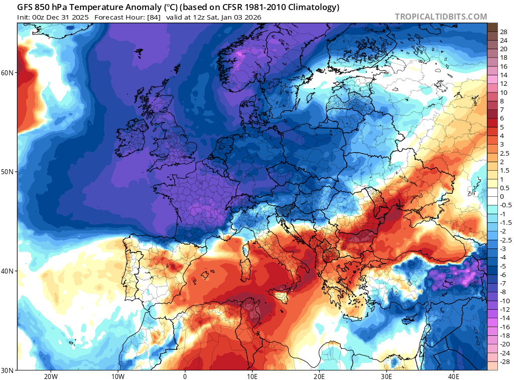
Image: Modelled 850hPa temperature anomaly at 1200 UTC on January 3, 2026. Source: TropicalTidbits.com
Where will snow fall this weekend and early next week?
Northerly airstreams over the UK bring snow chiefly to northern Scotland, Northern Ireland and north Wales. In contrast, many parts of England, Wales and southern Scotland are sheltered and can often remain dry.
An exception to this is south-west Wales which can be exposed to locally intense spells of rain or snow in what is colloquially known as a ‘Pembrokeshire Dangler’. When northerly winds blow across the relatively warm Irish Sea, convergence of surface winds develop into bands of showers, which can persist over many hours, sometimes days. In winter, this can lead to some significant snow accumulating across Pembrokeshire and neighbouring counties, sometimes Cornwall too. A Pembrokeshire Dangler in November 2025 brought power cuts to hundreds of homes across SW Wales and closed many schools. We could see a repeat of this event this weekend.
However, the greatest snow accumulations are likely to be across the NW Highlands in Scotland where locally over 50cm of snow could accumulate by early next week. In addition to the snow, there are likely to be gale force winds and blizzards which would be especially hazardous for travel. Although widespread disruptive snow is not currently expected across the UK, any fronts or troughs which develop in this northerly airstream could bring a spell of snow to other parts of the country. However, these systems are difficult to accurately predict more than a couple of days ahead.
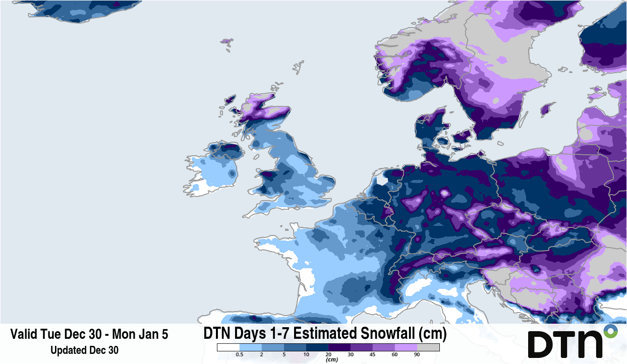
Image: Forecast snow accumulation between December 30 and January 5, according to the DTN 1FX model. Source: DTN.
‘Ice days’ ahead
The cold northerly winds will also result in a significant wind chill. From Saturday onwards, daytime highs of 1-4°C are expected across much of the UK but it will feel a good few degrees colder than this in exposed locations. Some parts of Scotland will likely remain below zero all day, known as an ‘ice day’, potentially over consecutive days. Overnight temperatures will also fall widely below zero across the UK meaning frost and ice will cause additional hazards to transport and power networks.
When will the chill end?
The answer is not clear at this stage. Weather patterns are likely to change later next week with low pressure systems pushing in from the Atlantic. While this will eventually bring a return to less cold weather, there could also be a spell of more widespread snow during the transition.