
Negative IOD gaining strength ahead of wet spring in Australia
One of Australia’s key climate drivers is gaining strength over the Indian Ocean, firming up the odds of a wet spring for large parts of the country.
The Indian Ocean Dipole (IOD) refers to an index that measures the difference in sea surface temperature anomalies across the tropical Indian Ocean. It’s an index watched closely by meteorologists because it can strongly influence rainfall and temperature patterns across Australia and other parts of the world, particularly during the Southern Hemisphere’s winter and spring.
A negative IOD occurs when warmer than average water sits off the coast of Indonesia, to the northwest of Australia, while colder than average water lies at the surface of the western Indian Ocean, near the Horn of Africa.
A negative IOD pattern typically causes more moisture-laden air to flow across Australia from the northwest, which can have the following impacts in Australia:
- Enhances the likelihood of above average rain across large areas of Australia, particularly in the south and east.
- Flooding events are more likely to occur during a negative IOD, especially when the IOD coincides with La Niña in the Pacific Ocean.
- Daytime temperatures are typically cooler in southern Australia during a negative IOD due to enhanced cloud cover, while days can be warmer than average in the country’s north.

Image: Typical rainfall impacts of a negative IOD.
What is the IOD doing now?
The IOD index needs to drop below -0.4 and remain there for several weeks to be classified as a negative IOD event.
The latest weekly IOD value was -0.91 on August 17, marking the 4th consecutive week below the negative IOD threshold. If the index drops below -0.94 in the coming weeks it will become the strongest negative IOD value we have seen since October 2010, which was Australia's 2nd wettest October on record.
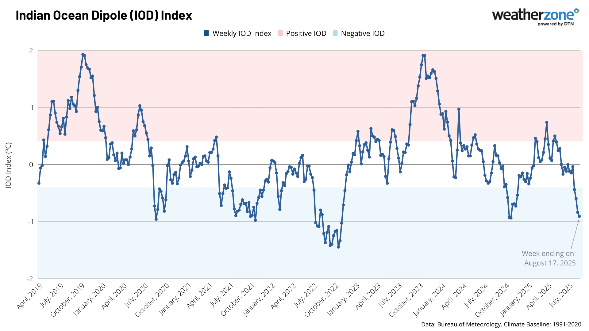
Image: Weekly IOD index values over the last six years.
The tropical Indian Ocean is in a clear IOD-like state that has remained in place for the past four weeks. Looking ahead, forecast models suggest that this negative IOD event could strengthen further into September and should persist throughout spring and possibly into early summer.
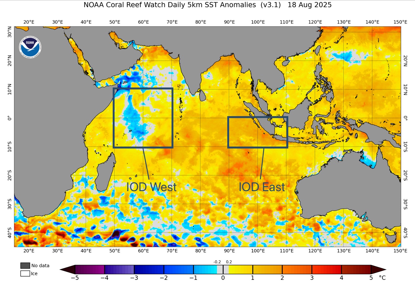
Image: Current sea surface temperature anomalies across the Indian Ocean, showing a clear negative IOD pattern in place.
The presence of a negative IOD this spring increases the likelihood of Australia experiencing above average rain in the next few months. This wet spring outlook has been highlighted by seasonal forecast models in recent weeks.
The map below shows one computer model’s prediction for monthly rainfall anomalies across Australia in October 2025. While these numbers should only be used as a rough guide, they paint a clear picture of wetter-than-average weather for much of the country in the middle of spring.
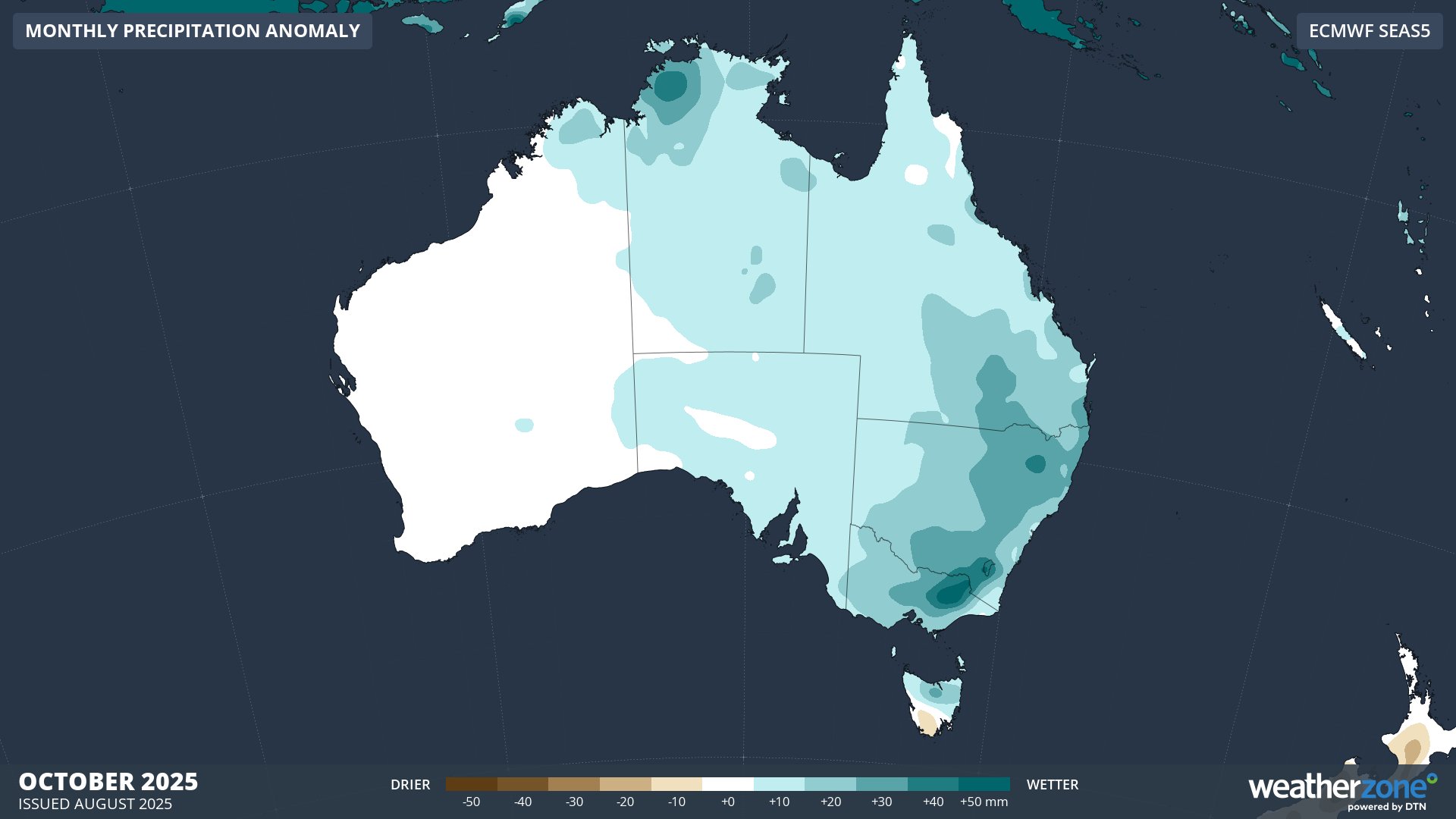
Image: Forecast rainfall anomaly in October 2025, according to the SEAS5 model.
Meteorologists will keep a close eye on the development of the IOD in the coming weeks and any other noteworthy changes in ocean temperatures surrounding Australia, including the tropical Pacific Ocean, where a weak La Niña signal may develop.
You can stay up to date with the latest weather and climate news for Australia by visiting the Weatherzone news feed on our website, app or Apple News channel.