
Melbourne will feel colder than 8°C for most of Saturday
A burst of very cold air for this time of year will chill Melbourne on Saturday after a brief outbreak of warmth on Friday.
Friday's predicted top in Melbourne is 28°C, while on Saturday, the mercury is expected to peak at just 14°C – but due to showers and cold blustery southwesterlies, Saturday's apparent (or "feels like") temperature will be below 8°C from midday onwards.
While rapid day-to-day temperature fluctuations are commonplace in Melbourne during spring, it’s still worth putting those two maximum temperatures in perspective.
- Melbourne can obviously get well up into the 40s in summer, but because a cool southerly so often follows extreme heat, the average maximum in January (the warmest month) is 26°C. This Friday’s high should be two degrees warmer.
- Melbourne’s average maximum in July (the coolest month) is 13.5°C. This Saturday’s high will be very much in that neighbourhood.
So it’ll be a taste of summer, then a taste of winter for our southernmost mainland capital as the working week merges into the weekend, with the chance of snowfalls in the Victorian Alps (and Snowy Mountains of NSW) for the second time this week.
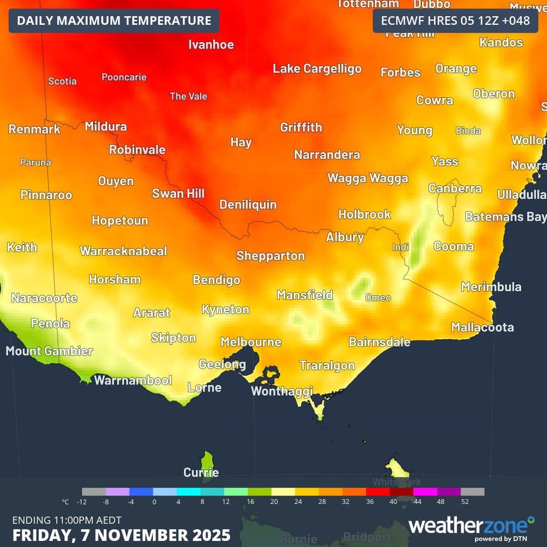
Image: Maximum temperatures across Victoria and adjacent areas according to the ECMWF model for Friday, November 7, 2025.
The cause is an approaching cold front. Ahead of the front, warm dry northerlies will push across Victoria. By Friday afternoon, a trough ahead of the front will generate widespread showers and storms, with showers likely in Melbourne by the evening.
Behind the front, air with polar origins moves over most of Victoria, with persistent rain or showers keeping a firm lid on temperatures.
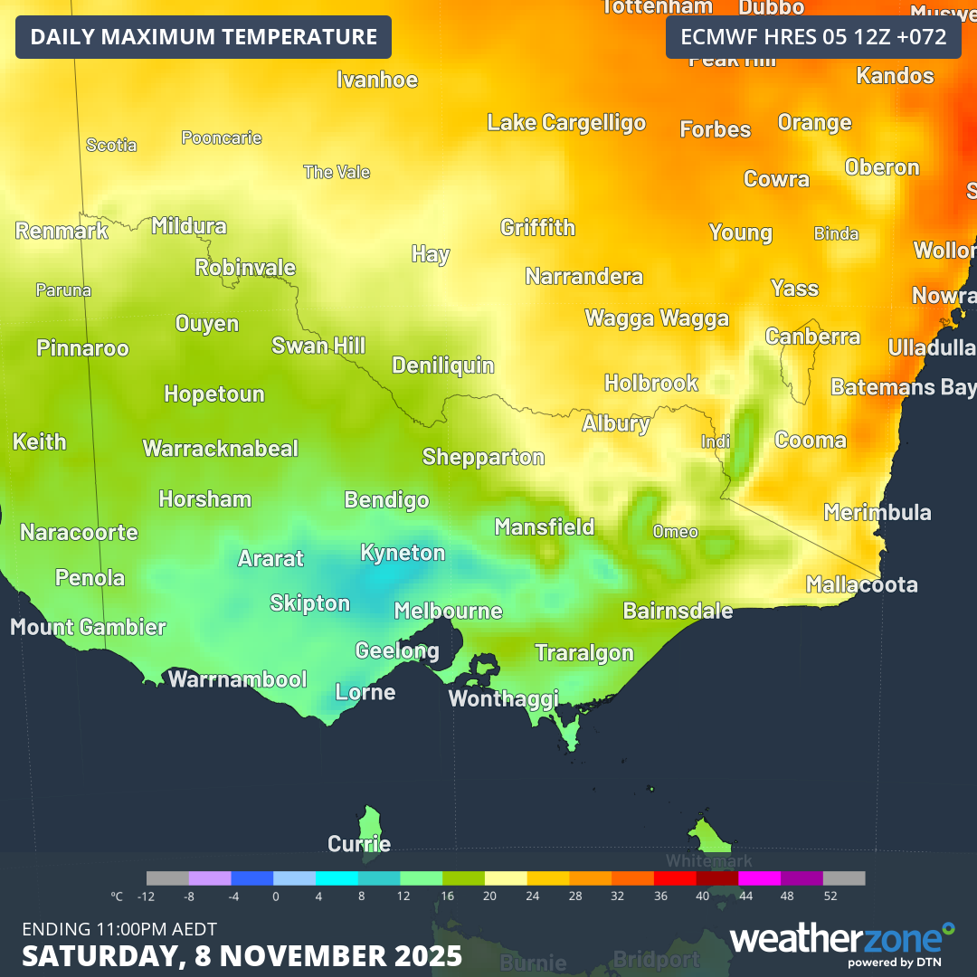
Image: Maximum temperatures across Victoria and adjacent areas according to the ECMWF model for Saturday, November 8, 2025.
While Saturday will be far from ideal for outdoor activities in Melbourne, it will continue the recent spell of wet days.
Rain fell on four of the first five days of November 2025 in Melbourne, with 39mm accumulated to date, which is roughly two thirds of the monthly average of 59mm.
With 5 to 10mm possible on Friday and 10-20mm on Saturday, it’s conceivable that Melbourne could exceed its November rainfall average after the first eight days of the month.
That would make two consecutive months of above-average rainfall – a statistic any Melburnian with a garden would welcome after seven of the eight months from February through to September saw below-average rainfall totals.
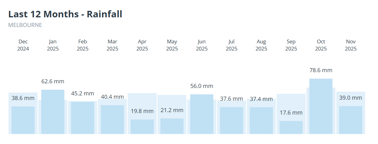
Image: Graph showing the last 12 months of Melbourne rainfall (compared to the monthly averages in pale blue) with the final column including rainfall up to November 5, 2025.
Over the first 10 months of 2025, Melbourne had received only about 80% of its running rainfall average.
Our Melbourne forecast is here.