
Melbourne shivers through coldest November day in 80 years
Parts of southern and eastern Victoria have endured their coldest and wettest November days in decades, with Melbourne itself measuring its equal-coldest November 24-hour maximum since 1945.
The cool conditions across Victoria were associated with brisk southerly winds ushering in a cold airmass and the persistence of cloud and rain. Despite winds blowing across the bay, with water temperatures of around 15ºC, the mercury in Melbourne failed to rise above a bone-rattling 12.7ºC across the city – about 8-9ºC below average. The maximum was achieved right before 9am on Sunday, November 9th, with daytime temperatures trending cooler than nighttime temperatures as seen below. When adding in the wind chill factor, temperatures would have felt as cold as 5-6ºC at times during the day, which is more winter-like than spring-like.
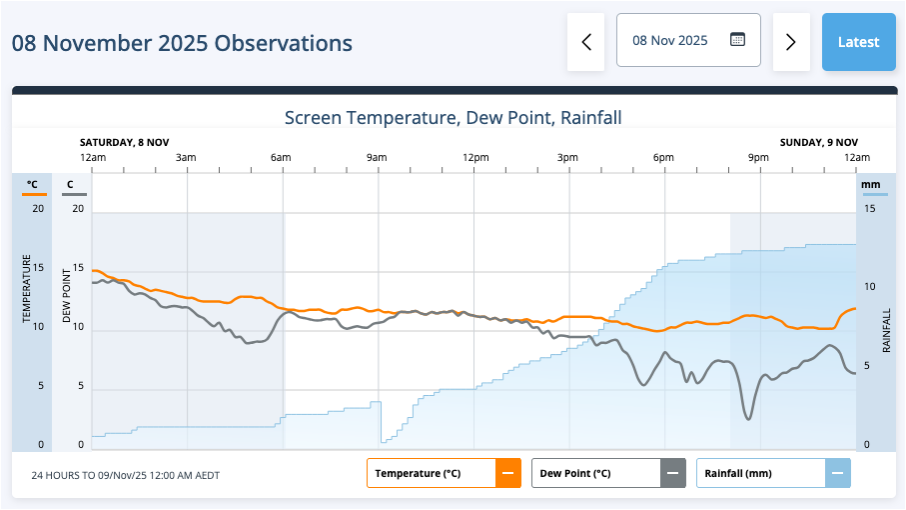
Image: Observed temperature, dewpoint and rainfall over Melbourne in the 24 hours to 12am on Sunday, November 9th, 2025. 'Nighttime' is shaded grey, with 'daytime' shaded white. Source: Weatherzone.
The chilly temperatures contrasted with the previous day on Friday when temperatures reached 25.8ºC. Temperature swings are not unusual at this time of year; however, this one will remain in the memory bank for Melbournite's due to its extreme nature.
The cloud was so thick over Victoria that, some parts of the state received no sunshine at all during November 8th, mostly confined to the Bairnsdale and West & South Gippsland forecast districts (see image below).
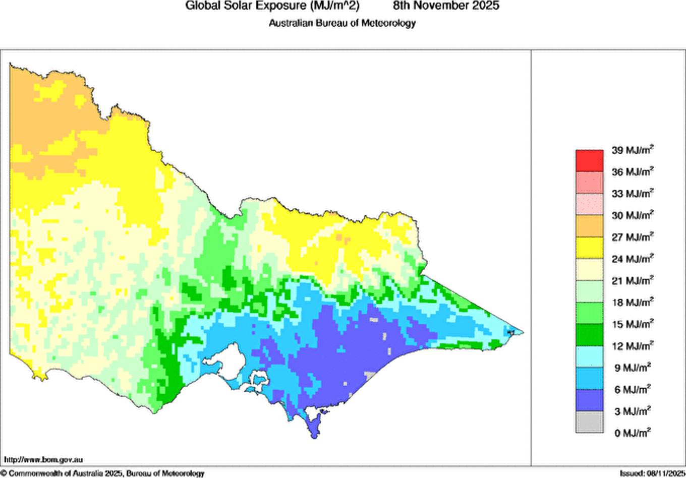
Image: Total solar exposure levels across Victoria on Saturday, November 8th, 2025. Parts of the southeast received no sunshine at all (grey). Source: Bureau of Meteorology.
The cold front responsible went on to bring some moderate to heavy rain to parts of central and eastern Victoria. The slow-moving nature of the front combined with some uplift over the elevated terrain brought high rainfall to some locations, with the highest 24-hour rainfall to 9am Sunday including:
- Mount Baw Baw, which received 77.4mm, the wettest November day in 18 years
- Yarram, which received 37.2mm, the wettest November day in 15 years
Broadly, central and eastern Victoria received 24-hour totals of 20 to 40mm. Rain coming from multiple directions can be seen in the following satellite loop.
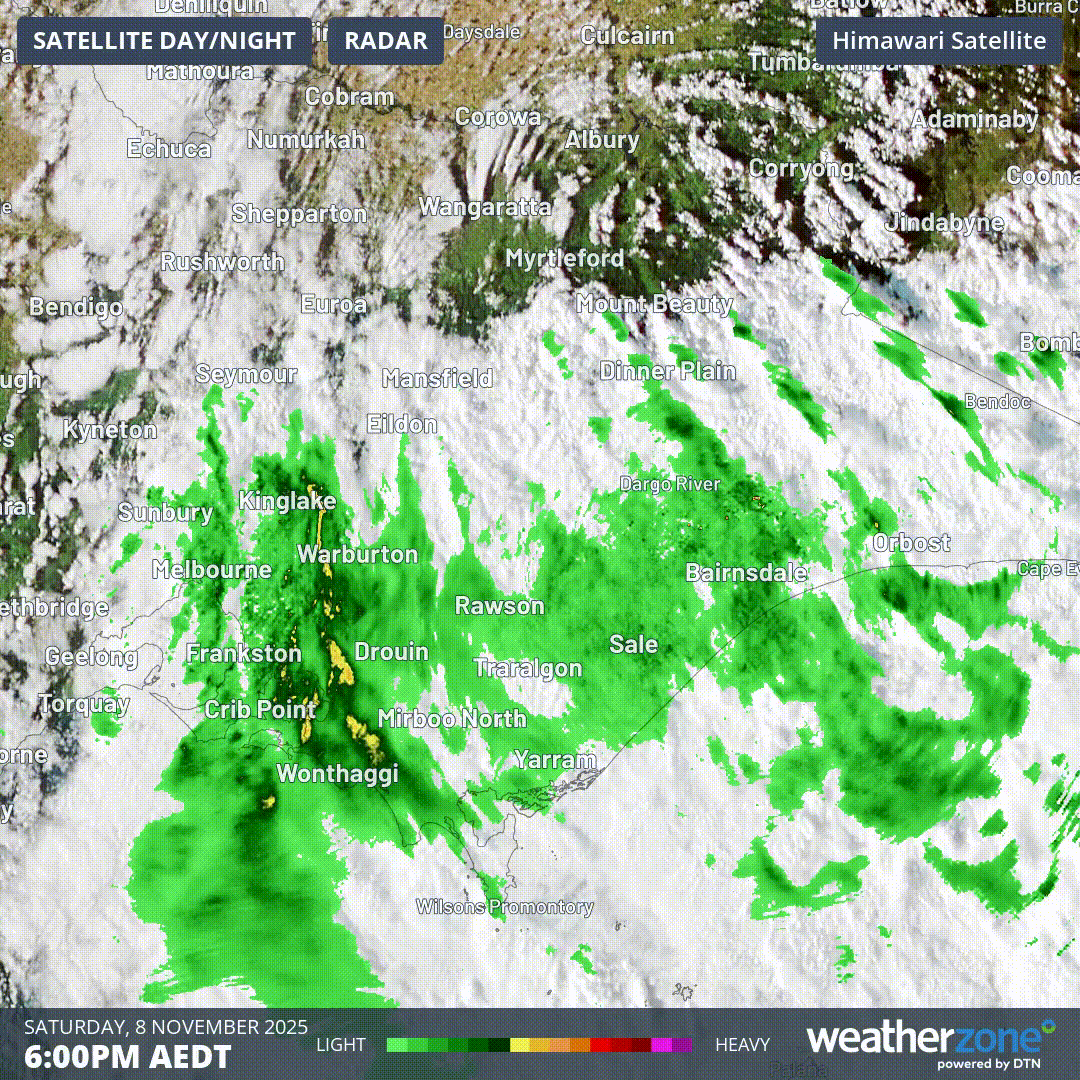
Animation: 8-hour loop from 6pm AEDT on Saturday, 8th November to 2am AEDT on Sunday, 9th November, showing the rain 'swirling' through Victoria in association with a cold front and upper low.
A brief spell of settled weather is expected on Monday as high pressure builds from the west. However, another cold front is waiting in the wings and will spread north-eastwards through central and eastern Victoria overnight on Monday and into Tuesday. This will bring another cool and wet day to Melbourne on Tuesday with a forecast high of 15ºC. However, it will feel more like 8ºC at times when combined with the rain and the breeze.
The good news for Victorians is that temperatures will recover from midweek, returning closer to the seasonal average as the week progresses.