Build Up heatwave over Top End
Of the last 22 days, 16 have averaged above 38.5°C for the Litchfield National Park gateway town of Batchelor in the Northern Territory. That’s the most for October and November (even though it's only November 4th today) since 2019. The latest hot spell also included the longest consecutive run above 38.5°C—9 days between Friday 13th and Saturday 1st—for the town since 2003.
The NT is no stranger to heat, especially in this Build Up season but it's been hotter than usual. Official Batchelor records only go back to 1994 but still show October 2023 was the hottest since 2003.
Tindal, a bit further south near Katherine, has also had a high number of near 40°C days this season, sitting on 23 since October 1st, more than the number of such days for all of October and November in 2022. Every day except two have maxed out over 37°C since the beginning of October.
Heatwave warnings are once more in place.
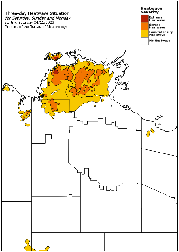
Image: Heatwave warning for the coming three days for the NT. From http://www.bom.gov.au/nt/warnings/heatwave.shtml
Coastal areas have not been as hot in absolute terms, thanks to daily seabreezes but have still been warmer than average. Darwin's 38°C on October 15th was its warmest October day since 2019, and the month as a whole came in at the warmest in terms of maxima since 2009.
The culprit is not warm sea surface temperatures (SSTs). Unlike over waters to the east of Australia, current SSTs off the NT are generally close to average.
Instead, the cause of the persistent heat is reduced cloudiness over northern Australia. With the tropical sun beating down for 12+ hours every day and no typical Build Up thunderheads shading out some of the sky, the heat accumulates. The Build Up season normally makes people a bit mad (well, at least the European descendants) with the heat and humidity. Though humidities this year have been at their lowest since 2019, the heat is making up for any respite such drier conditions might imply.
Many are probably craving the monsoon, despite its crazy levels of humidity. But in an El Niño year, like this year, the monsoon typically arrives later than usual.
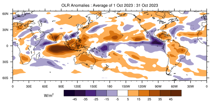
Image: Outgoing Longwave Radiation anomalies for October, showing positive anomalies (reduced cloudiness) over northern Australia. From Bureau of Meteorology.