
Major winter storm to hit US on Friday into weekend
A massive push of arctic air is going to set up a major winter storm system for the southern half of the United States for Friday through the weekend, January 23-25. Widespread impacts including heavy snow and freezing rain, flooding, and extremely cold temperatures are in the forecast through the weekend, with the cold hanging on into next week.
Polar air plunging over United States
This weekend’s cold snap will all be set up by a cold front pushing south through the northern US on Thursday and Friday across the south. The air behind the front will be sourced straight from the North Pole and extremely cold.
If the snow depth across Canada and the northern U.S. was deeper, like it should be this time of year, it would be even colder. But this massive push of cold air will still result in temperatures that are 20-40 degrees Fahrenheit below normal.
This is coming essentially at the coldest time of the year. The third week of January is statistically the coldest week for most of the U.S. east of the Rockies. This may be a couple of days late, but it is going to be a massive change for a lot of areas.
High temperatures on Saturday are likely to stay below zero F in the eastern Dakotas, Minnesota, and Wisconsin, with 10s F in the Texas Panhandle through the Ohio Valley. While those maximum temperatures are already bitterly cold, lows will be more than 20 degrees below zero F in the Upper Midwest and single digits as far south as western Texas, the Lower Mississippi Valley, and the Mid-Atlantic, which will continue into early next week.
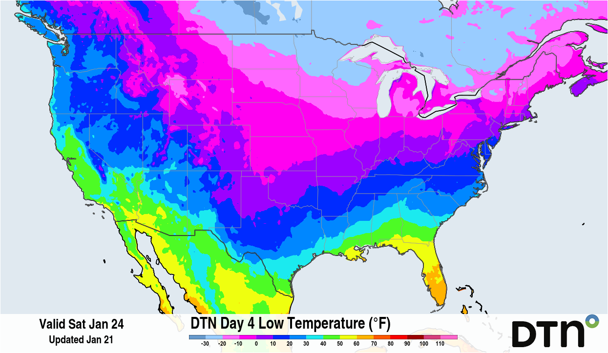
Image: Extremely cold temperatures are forecast to spread through the U.S. on Saturday, Jan. 24. Source: DTN.
Major winter storm to bring rain, ice and snow
This punch of cold air will be the precursor to a major winter storm. The storm was off the coast of California as of early Wednesday but came ashore on Thursday night and will spread eastward for Friday and through the weekend. The storm will be deep enough to pull up a significant amount of moisture from the Gulf over the top of the cold air, resulting in a wide band of heavy, mixed precipitation.
Across the Gulf Coast, temperatures are likely to be warm enough for all rain, and some thunderstorms may occur. Just to the north, from central Texas to southern Oklahoma east through the Mid-South and Carolinas, the air above the surface will be warm enough for rain, but the surface will be below freezing, resulting in heavy freezing rain.
Model amounts have potential for over 0.50” of ice, though ice accumulation is a tricky one to forecast. Some of the rain that falls won’t necessarily stick to all surfaces immediately. Heavy freezing rain may not accumulate as much as models project and instead runoff. But the forecast amounts do not need to come true to have significant impacts at the surface. Heavy rain could cause some areas of flooding as well, including the areas that see freezing rain, as the ground will quickly freeze and the rain will runoff better.
The rain will eventually turn to a mix of sleet and then snow working north to about the I-70 corridor from Kansas through Ohio. TA deepening low-pressure center on Sunday should pull more snow farther north through the Northeast as well.
Snowfall amounts may reach over a foot in a wide band from eastern New Mexico through the Texas Panhandle, Oklahoma, Tennessee, and Virginia, with lower amounts farther north. Some areas from Richmond, Virginia through Boston, Massachusetts could see close to or over a foot of snow as well, resulting in major problems for the Northeast Megalopolis.
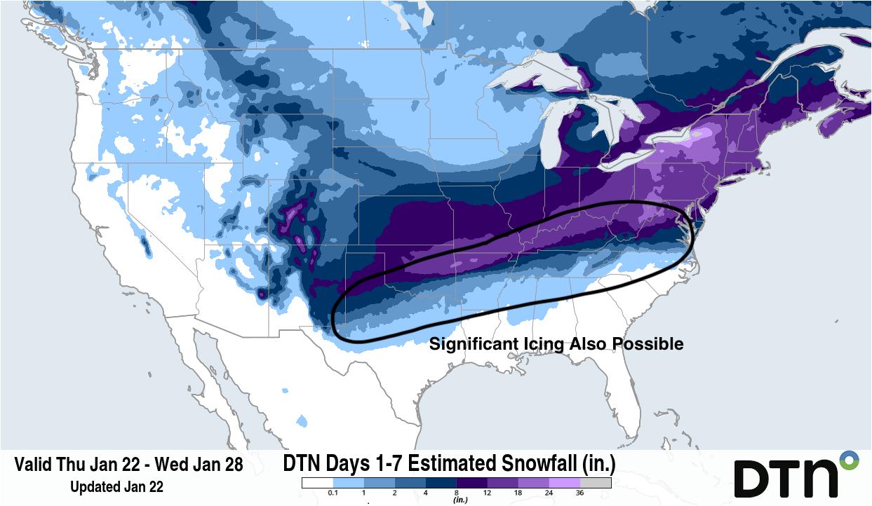
Image: A major winter storm will produce a wide band of heavy snow from the Southern Plains through the Mid-Atlantic this weekend. There is potential for significant freezing rain along and south of the heaviest snow as well. Source: DTN
Mixing with freezing rain and sleet may cut into some of the extreme amounts, however, and models may be overdoing snowfall in some areas. But if the temperatures are cold enough and the snowfall rates heavy enough, that could be overcome, resulting in more snow where ice is currently being forecast, and upping snow totals. Wide ranges of accumulations are therefore likely in the heaviest snow band.
Models are mixed on how far north the band of snow will extend, with some models cutting it off abruptly near I-70 through the Midwest and I-90 through the Northeast. Others expand it farther north than that. Dry, arctic air is likely to cut off the snow quickly to the north, but where that exactly sets up is still uncertain. The models also have some uncertainty with the overall track of the system and how far south the cold air will get. Still, this is shaping up to be a major winter storm with multiple impacts for a wide area of the country. Most of the country will feel at least some of the event whether it be cold, snow, or freezing rain.
Wind hazards exacerbating impacts from this system
Winds are not forecast to be extremely strong with the system, but even moderate winds that coincide with heavy, wet snow and ice may cause significant issues for infrastructure including downed trees and powerlines. The cold air that follows will slow crews trying to restore power as well. Ice of any kind will make travel nearly impossible for days across the South as crews have limited resources to battle such a significant event. Some daytime melting and refreezing overnight will also extend the issues well into next week.