
Major flooding in NSW with more rain on the way
Rivers are raging in parts of NSW today, with major flooding imminent for Gunnedah and more heavy rain on the way later this week.
November has already been an exceptionally wet month in NSW, with most of the state receiving more than two months' worth of rain during the last three weeks.
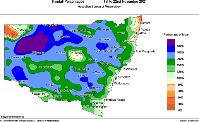
Image: Observed rainfall percentages during the first 22 days of November. Source: Bureau of Meteorology.
This soaking rain has inundated rivers and caused minor to major flooding across catchments in central and northern parts of the state.
Last week, a major flood peak crept down the Lachlan River in Central West NSW, prompting an evacuation order in parts of Forbes.
More recently, heavy rain has been soaking northern NSW during the last three days and causing rivers to bulge across the state's northern inland.
Several rivers were experiencing minor to moderate flooding in NSW on Tuesday morning. Amid the list of flood warnings that were in effect at 9am AEST on Tuesday, three were for major flooding. These major flood warnings were for the Gwydir, Namoi and Lachlan Rivers.
The video below shows water rushing over Apsley Falls to the east of Walcha. Over the last four days, Walcha has received 83mm, which is exactly one month's worth of rain at this time of year.
Further east, Mount Seaview has collected 223mm during the last three days, well above its November monthly average of 167mm. This brings Mt Seaview's running monthly total up to 364.4mm, making it the wettest November in six years. Impressively, the running annual total has now hit 3433.4mm, making this already site's wettest year since 2009.
Major flooding is likely to develop at Gunnedah around midday today, before the river peaks at around 8.10 metres tonight. Major flooding could also develop at Yarraman around midday today.
Looking ahead, showers and thunderstorms will continue to affect NSW on every day during the rest of this week. The heaviest rain will occur between Wednesday and Friday as an upper-level low pressure trough sweeps across the state, causing the atmosphere to become more unstable.
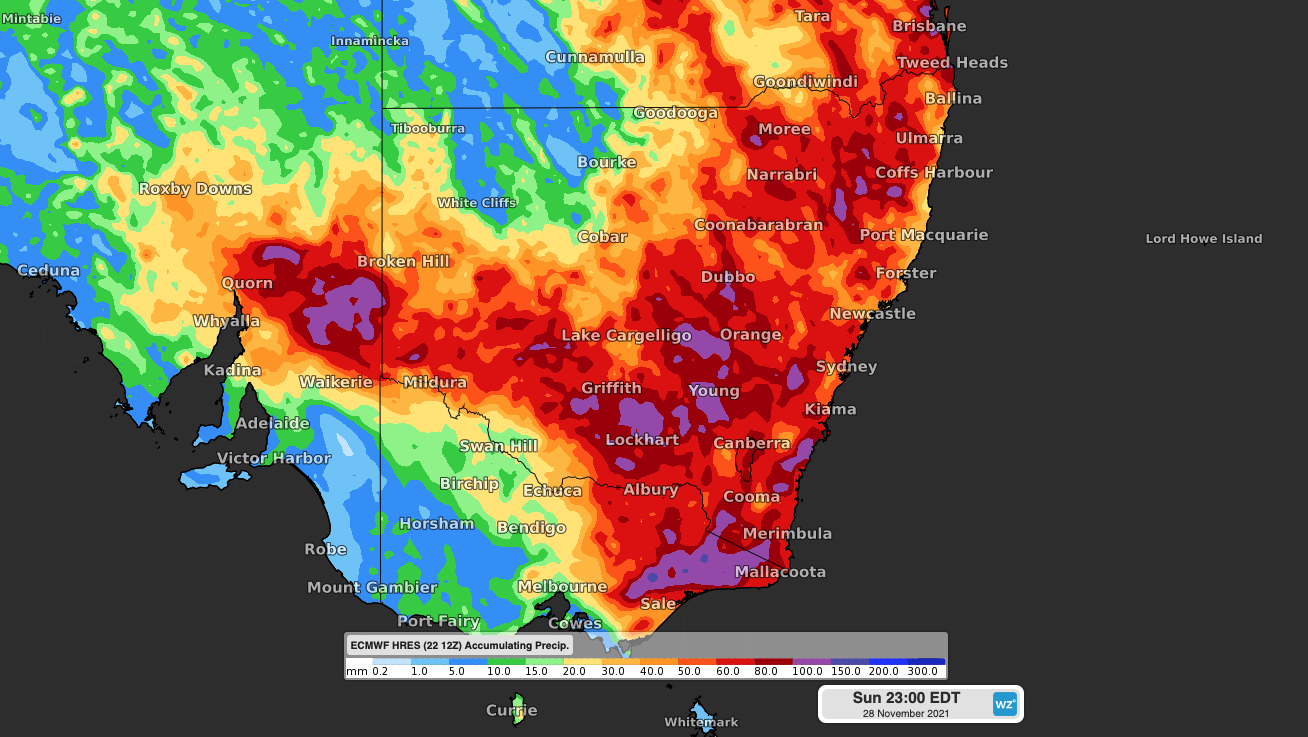
Image: Forecast accumulated rain between Tuesday and Sunday this week, according to the ECMWF-HRES model.
Widespread falls of 40-80mm are likely across multiple districts in NSW by the end of this week, with some places likely to see more than 100mm. This wet weather will affect already inundated rivers across the state, causing more flooding.
Stay up to date with the latest weather and flood advisories in your area for the most up-to-date information on this evolving weather event.