
Longest Aussie snow season in three years
For the first time since 2022, some Australian ski resorts will make it through to October, with roughly half of all lifts still running as we approach the end of September at the "big five" of Mt Buller, Falls Creek and Hotham (Vic), as well as Thredbo and Perisher (NSW).
This is good news for those visiting the mountains in the school holidays, with the Victorian and Queensland school holidays already upon us and the SA, NSW and ACT school holidays beginning at the end of this week.
One Perisher instructor reported that 200 Queensland schoolkids are booked in for first-time ski and snowboard lessons this Monday, September 22. When you factor in accommodation, travel and meals, that’s a big late-season boost to the Snowy Mountains economy which the region sadly missed in 2022 and 2023.
Those hitting the snow this week will find a deep cover up high with thinning conditions on lower slopes.
The most recent Snowy Hydro manual reading at Spencers Creek – at an elevation of 1830m roughly halfway between Perisher and Thredbo – was 173.8cm, taken last Thursday. That means the season peak will almost certainly be the 220.4cm recorded at the start of September.
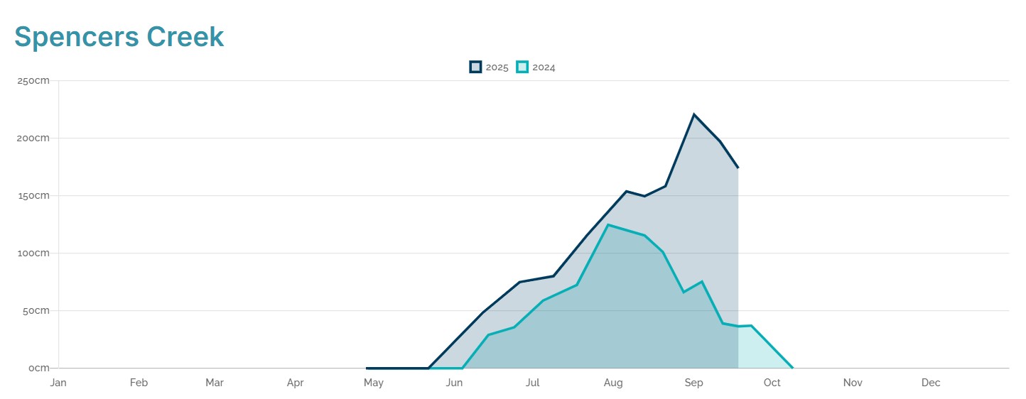
Image: Despite snow loss last week, the 2025 season graph (dark blue) shows a positive picture, especially compared to last year (light blue) when the season was done and dusted by this stage of September. Source: Snowy Hydro.
Conditions across the mountains this Monday were reportedly icy early, but the snow surface should soften as the day goes on.
Rain fell across the mountains on two separate occasions in recent days, followed by light snowfalls as cooler air moved in. That cold air had the effect of freezing the entire snowpack. Imagine you put a half-eaten Mr Whippy soft-serve cone in the freezer overnight. That gives you an idea of the consistency of the snow surface early on Monday morning.
September snow is back at Hotham. Perfect timing for the school holidays! ????❄️ pic.twitter.com/jjUj7xGx6K
— Hotham (@_hotham) September 21, 2025
This freeze/thaw cycle will be the pattern for the next few days, meaning that mid-morning should be the perfect time to put a few turns in – in the sweet spot before the frozen soft serve turns into the heavy slushy surface that skiers call "mashed potato".
In terms of snowfall potential, the working week ahead should see a mix of clear skies and intermittent cloud with generally breezy conditions. There’s the chance of light snow flurries, but nothing that will significantly add to the cover. By next weekend, there could be a top-up of a few centimetres.
With two weeks left in the official Aussie snow season, we’ve probably seen the last major blizzard. But heavy snowfalls earlier this season mean the cover remains in good shape for this time of year. Please keep checking the Weatherzone snow page for the latest forecasts, live cam images and more.