
Locals stranded on roofs in unprecedented Lismore flood
The weather system that deluged SE Queensland is now parked well and truly over NE NSW, and widespread evacuations are underway in the city of Lismore after the town levee was overtopped early Monday morning.
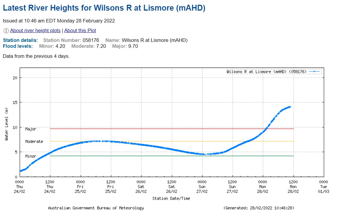
The Wilsons River in Lismore will reach its highest flood peak on record today, after exceeding the March 1974 peak of 12.15 metres this morning. The river reached 14.2 metres just before midday and the Bureau of Meteorology suggests it may reach as high as 14.4 metres this afternoon.
Source: BoM.
Huge parts of the city of 44,000 residents are now submerged, and there are dramatic scenes unfolding across town as we write this story, with many residents forced to flee to their roofs to await rescue.
A woman and toddler sitting on the roof of their South Lismore home waiting to be rescued. @9NewsSyd @TheTodayShow @nbnnews pic.twitter.com/kwe2XGzp2W
— Olivia Grace-Curran (@livgracecurran) February 27, 2022
Desperate call for help from #Lismore local Lucy Vader. Stuck on a roof at 36 Macaulay St. Her dog is inside her home. "I’m having to flex my back to stay on the roof and not slip off" She is one of hundreds desperately needing rescuing from floodwaters @nbnnews @9NewsSyd pic.twitter.com/LXcCkFtFLb
— Olivia Grace-Curran (@livgracecurran) February 28, 2022
Videos posted by locals show murky water at the level of shop awnings as it gushes through the CBD.
What my town currently looks like, I can’t even put into words how gutted and shocked I am. My heart is aching for everyone.
— Korra_Ryan (@Korra_Ryan) February 27, 2022
Vid- N Hall#lismoreflood #floods pic.twitter.com/cSjw6YZ7f5
This is Lismore's worst ever flood disaster and the SES has been overwhelmed by calls. Meanwhile the ADF is currently unable to fly in to assist due to the ongoing torrential rain. So locals are doing what they can to help each other.
In Lismore we have done floods for ever. This is not a flood - this is catastrophic. This is extreme. This is climate change. Lismore needs back up. People are on and in their roof some are screaming for their lives and water is still rising. Friends are rescuing friends. pic.twitter.com/NwikdHTX0V
— Sue Higginson (@SueHigginson_) February 27, 2022
This is an unfolding disaster and we will update this story throughout the day.
As a background to why this situation, is occurring, phenomenal amounts of rain were recorded in the catchment of the Wilsons River overnight.
- For example, the weather station at Dunoon, just north of town, registered 775 mm in the 24 hours to 9 am Monday.
- That's the heaviest daily total anywhere in Australia in the month of February since 1977.
- It’s also the second-wettest day on record (any month) in NSW.
- The city of Lismore itself had 467 mm overnight.
- In the week leading up to last night’s phenomenal rainfall, the city of Lismore recorded almost 300 mm in total, with higher readings in the nearby hills and ranges.
In summary, vast amounts of rain have fallen on extremely saturated ground, and that is a recipe for the disaster currently playing out.
READ MORE: SECOND HEAVIEST DAILY RAINFALL EVER OBSERVED IN NSW
Please stay safe if you're in the area, or any of eastern Australia’s flood-affected zones and please take on board the official Flood Safety Advice from the Bureau of Meteorology:
In life threatening emergencies, call 000 (triple zero) immediately. If you require rescue, assistance to evacuate or other emergency help, ring NSW SES on 132 500.
- Avoid drowning. Stay out of rising water, seek refuge in the highest available place.
- Prevent damage to your vehicle. Move it under cover, away from areas likely to flood.
- Avoid being swept away. Stay out of fast-flowing creeks and storm drains.
- Never drive, ride or walk through flood water. Flood water can be deceptive and dangerous.
For more emergency information, advice, and access to the latest river heights and rainfall observations and forecasts: