
Lines of severe storms hitting SA, with more dangerous weather on the way
Several lines of heavy rain and severe thunderstorms are moving over southern districts of SA this morning, kicking off two days of dangerous weather in southern Australia.
The animation below shows lines of intense storms moving from west to east across SA's Yorke and Eye Peninsulas on Thursday morning.
These thunderstorms are 'training', which means multiple thunderstorms moving over the same location, one after the other. Training thunderstorms are capable of causing flash flooding by inundating an area with round after round of heavy rain.
The image below shows that thunderstorms have also been sweeping across some eastern areas of SA on Thursday morning as well.
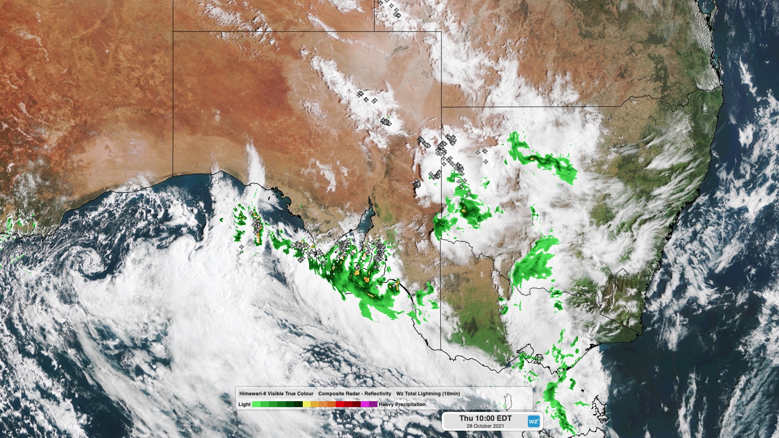
Image: Composite satellite, radar and lightning strikes at 10am AEDT on Thursday.
At 9am CDT on Thursday, a severe thunderstorm warning was in place for the Adelaide Metropolitan, Mount Lofty Ranges, Lower Eyre Peninsula, Yorke Peninsula, Flinders, Kangaroo Island and parts of West Coast, Eastern Eyre Peninsula, Mid North, Murraylands, Upper South East and North East Pastoral districts.
Within these warnings areas, damaging winds are the main threat with storms over the state's eastern inland, while heavy rain, large hail and damaging winds are all possible with storms in southern parts of the state.
Video: Hail on the Yorke Peninsula on Thursday morning. Source: @redwing_farmsa / Instagram
A detailed severe thunderstorm warning was also issued for the Adelaide area shortly after 9am local time, as the first in a series of severe storms approaches the city from the west.
There is also a severe weather warning in place across most of SA today for damaging winds independent of thunderstorms.
Today's dangerous weather is being caused by a deepening complex low pressure system and associated trough, which are crossing SA this morning and heading towards NSW, Vic and Tas.
The low and trough will continue to produce severe storms and damaging winds over SA throughout Thursday.
Showers, potentially severe storms, areas of heavy rain and strengthening winds will also spread into western NSW, Vic and Tas today and tonight. Warnings for severe thunderstorms, damaging winds or flooding are already in place in each of these three states.
The impending storms have also prompted a 'high risk' alert for thunderstorm asthma in western Victoria on Thursday, with the Victorian Department of Health issuing the alert for the state's Mallee, South West and Wimmera districts.
A high-risk of epidemic #ThunderstormAsthma is forecast in the Mallee, South West and Wimmera districts tomorrow.
— VicGovDH (@VicGovDH) October 27, 2021
This is the first high risk of the season and a good reminder to be prepared. 1/2 pic.twitter.com/kAeHLkHxXk
One of the main threats during Thursday night and Friday morning will be heavy rain over western Vic and Tas, hear and to the west of the complex low pressure system. This rain has the potential to cause both flash and riverine flooding.
The heavy rain and strong, potentially damaging winds will contract to Tasmania and Victoria on Friday morning as the low pressure system moves over Bass Strait.
Calmer weather will return from Friday afternoon and night as the low finally moves out into the Tasman Sea.