
La Niña to weaken, El Niño possible later this year
La Niña is showing signs of weakening and some computer models are hinting at the possibility of a flip to El Niño conditions later this year.
The oceans and their slowly changing temperature patterns have a profound impact on the configuration of the world’s atmospheric circulations.
Foremost among these climate drivers is the gradual oscillation between cool and warm waters in the equatorial Pacific, known as the El Niño-Southern Oscillation, or ENSO. This cycles between La Niña (cool phase) and El Niño (warm phase), typically every 1 to 3 years.
We are currently at the peak of a rather weak La Niña episode, which despite its limited power has helped to carve out the shape of North America’s pressure patterns through the winter and set the stage for occasional Arctic outbreaks, especially across the north-central US.
The atmosphere is complex and there are other factors involved at shorter “sub-seasonal” time ranges, like the state of the stratospheric polar vortex; but what we have seen so far this season has approximated idealized wintertime La Niña patterns.
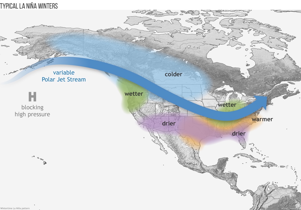
Image: Map of North America showing position of jet stream and climate impacts during La Niña winters. Source: NOAA climate.gov
The effects of La Niña and its disappearance
During La Niña, the jet stream pushes northwards over the eastern Pacific, with high pressure tending to recur over the Gulf of Alaska. This causes a large-scale trough to form downstream, with the jet stream dipping southwards across the central and eastern US.
As this has been a weak La Niña, however, its impacts have been less consistent. Interruptions to the broad set-up have come from the high pressure center occasionally retrograding westwards towards the Bering Sea, allowing Pacific-sourced air to wash across the US. This has brought a couple of periods of unusually warm temperatures, with some record highs here and there.
But what lies ahead? La Niña is due to weaken imminently, and there are already signs that cold temperature anomalies in the tropical Pacific are being eroded from the west as trade winds shift. A steady disappearance of colder water will occur through late winter and spring, leading to a period of neutral ENSO conditions. Eventually the ocean should flip the script and warm towards El Niño by the fall.
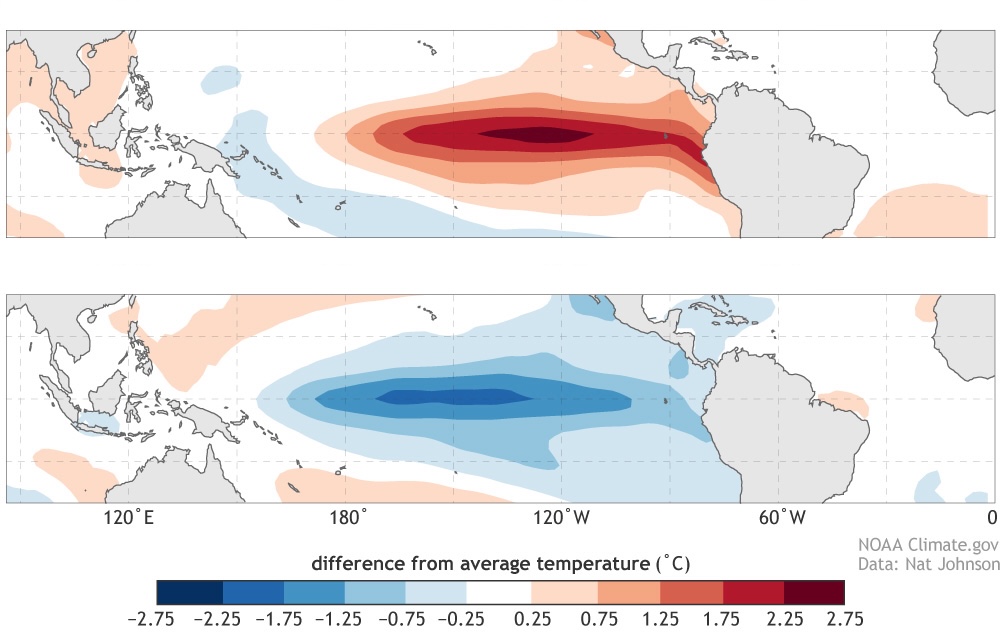
Image: Sea surface temperature anomalies during strong El Niño events (top) and strong La Niña events (bottom). Source: NOAA climate.gov.
Changes in the trade winds
Trade winds blow towards and along the equator, but when they go through periods of strengthening and easing, they alter ocean surface currents. A stronger east to northeasterly flow across the tropics pushes relatively warm water westwards and forces an upwelling of colder water from the deeps to replace it. As this process continues, the cooling spreads across the tropical Pacific basin and La Niña develops.
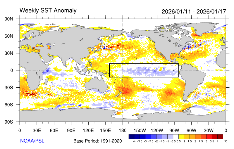
Image: El Niño region (boxed) shows a recent easing of cold waters at the western edge, with some warmer anomalies even already starting to mix in. Source: NOAA, Physical Sciences Laboratory.
However, when the trade winds slacken - or even reverse – warm water sloshes back eastwards, starting a change towards the El Niño phase. This is what we are starting to see, with “westerly wind bursts” developing near and west of the dateline. Those westerlies, according to global weather models, are due to strengthen considerably, which could precipitate a steady or even rapid warming of the sea, and thus the demise of La Niña.
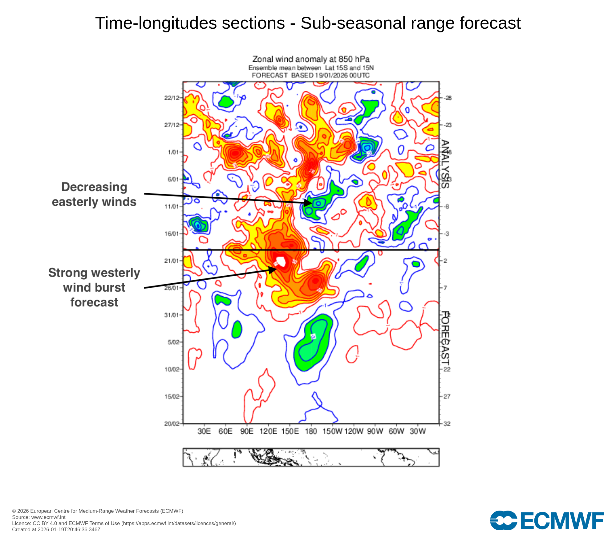
Image: Hovmöller diagram of observed and forecast zonal winds over the tropics at about 5,000ft. Source: ECMWF.
The emergence of El Niño
The western Pacific is not only warming at the surface. There is a growing pool of warmer-than-average water at depth as well, waiting to unleash itself. This growing subsurface warmth is usually a precursor to a change to El Niño.
For a while, the effects of this La Niña will linger, as there is a lagged response in the atmosphere to such slowly evolving climate drivers. But through the spring, the neutral ENSO will mean weaker impacts on global circulations, so it will be less of a long-range forecasting tool.
However, if El Niño develops as expected, it will probably strongly influence conditions later in 2026, with very different patterns developing for next winter. The graph below shows forecasts from global models, and with all pointing towards El Niño to varying degrees, confidence is rather high that it will develop.
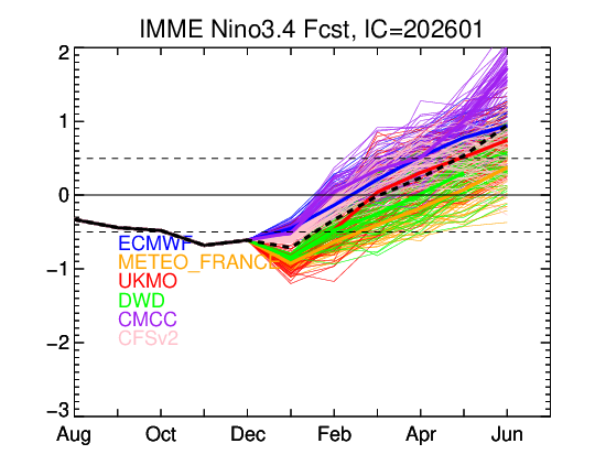
Image: A selection of global models shows varying degrees of development of El Niño through summer and into fall. Thick dotted line is the mean. Dashed lines show La Niña and El Niño thresholds. Source: NOAA/Climate Prediction Center.
Hurricane season
El Niño could start to make its effect felt through the summer and into the fall. Not least is its probable impact on the hurricane season. Although it is far too soon to start bandying around any numbers, we can at least note the canonical impacts of El Niño on hurricanes. Most importantly it tends to increase wind shear over the Atlantic Ocean – the change in wind speed and direction with height. As hurricanes need low wind shear to develop, then there could be somewhat subdued activity in the Atlantic this year.
Winter of 2026-27
On the reasonable assumption that El Niño will persist through next winter, we can take a very early look at how things might shape up.
Although it is far too early to make a forecast, we can look at typical El Niño patterns, which are very different from those during La Niña winters.
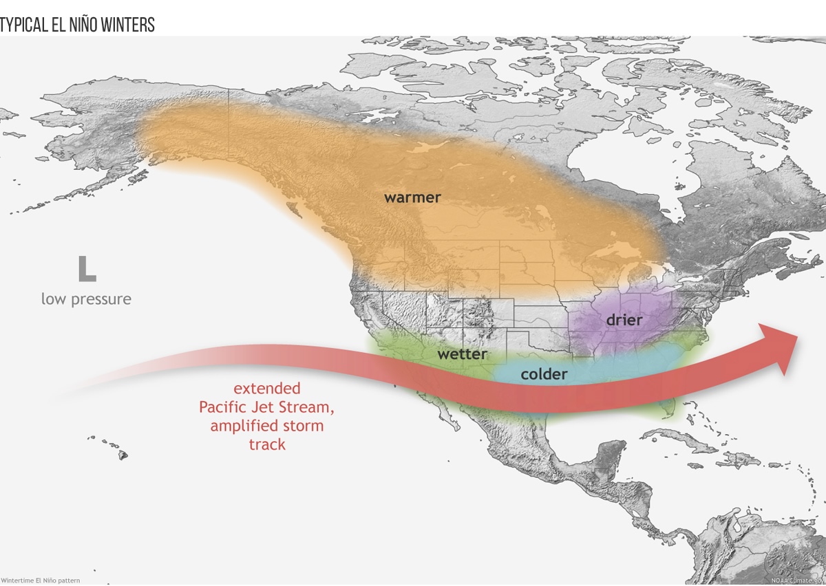
Image: Map of North America showing position of jet stream and climate impacts during El Niño winters. Source: NOAA climate.gov
Instead of high pressure in the East Pacific, there tends to be an area of low pressure, with the polar jet stream diverting farther north. All other things being equal, this tends to reduce the chances of Arctic outbreaks, with the northern US and at least western Canada often having milder winters than usual. By contrast, the Pacific jet is usually stronger during El Niño, which can subdue temperatures across the southern US due to more frequent passage of low pressure systems.