
La Niña declared days out from summer – what does this mean for Australia?
The Bureau of Meteorology has declared that La Niña is underway in the Pacific Ocean. So, what does this mean for Australia’s weather this summer?
What is La Niña?
La Niña is one phase of a Pacific Ocean phenomenon called the El Niño–Southern Oscillation (ENSO). The other phases of ENSO are El Niño and neutral.
When La Niña is occurring, abnormally cool water lies near the surface of the central and eastern tropical Pacific Ocean and warmer than normal water sits in the western tropical Pacific. This sea surface temperature pattern is associated with changes in the overlying atmosphere, with easterly trade winds typically becoming stronger and blowing extra moisture towards the western side of the Pacific Ocean.
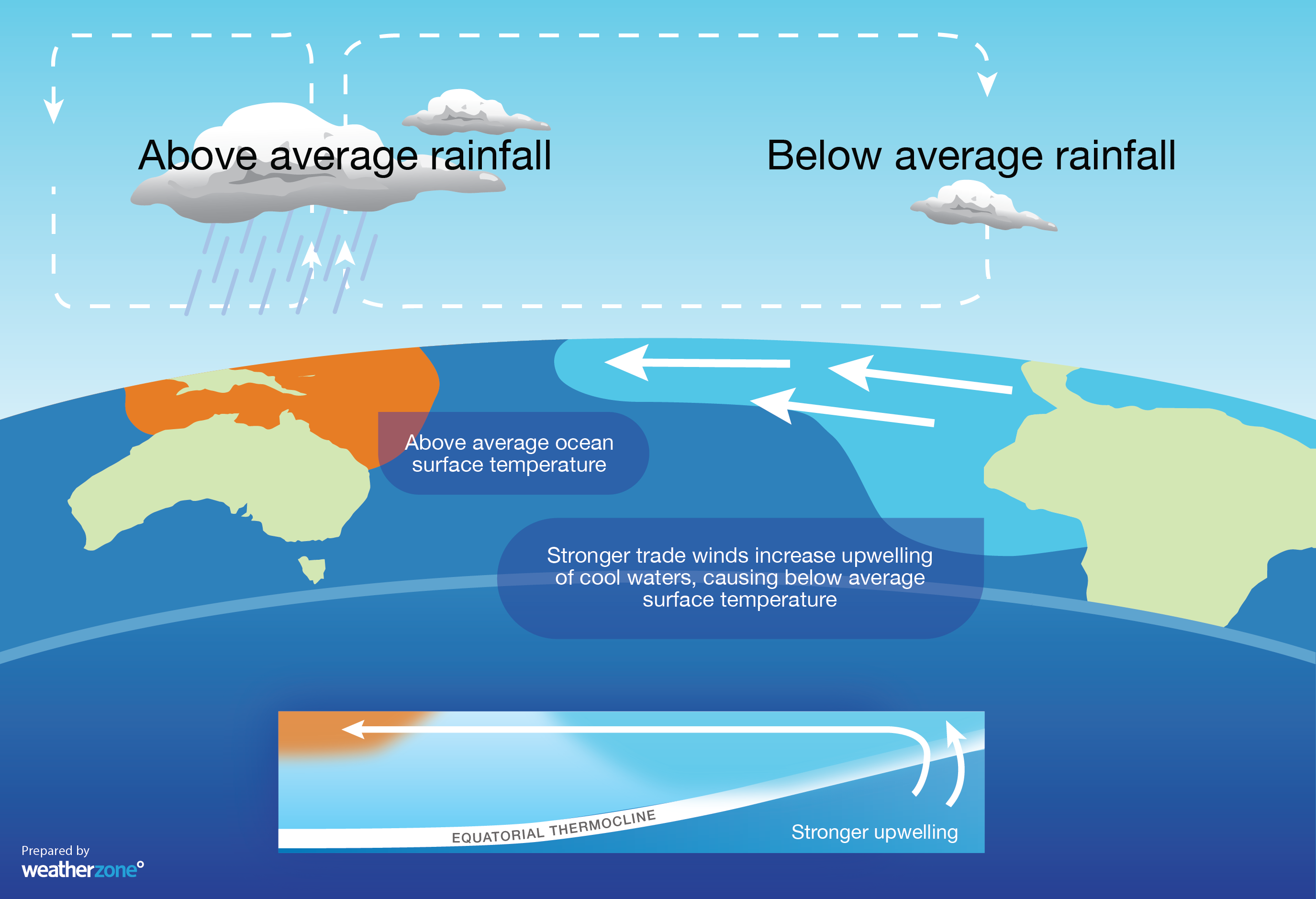
Image: Typical oceanic and atmospheric responses to La Niña. Source: Weatherzone.
What does La Niña mean for Australia?
La Niña can have a strong influence on Australia’s weather. While El Niño’s weather impacts are mostly felt during winter and spring, La Niña can have a noticeable effect on Australian weather in summer.
Australia typically sees above average rain over northern and eastern parts of the country when La Niña is in place during summer. Eastern Australia's mean summer rainfall is about 20% higher during La Niña, with the east coast typically seeing a stronger rainfall response to La Niña in summer than it does in winter or spring.
Daytime temperatures can also be suppressed over eastern and northern Australia when La Niña occurs in summer, which is associated with enhanced cloud cover over these parts of the country.
Tropical cyclone activity can also be amplified in the Australian region when La Niña is occurring.
The maps below show the average rainfall and maximum temperature changes observed across Australia from eight to nine past La Niña events combined.
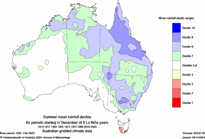
Image: Average summer rainfall deciles under the influence of La Niña. The green and blue shading shows where summer rainfall is typically above average during La Niña. Source: Bureau of Meteorology.
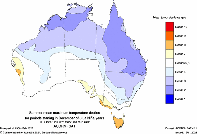
Image: Average summer maximum temperature deciles under the influence of La Niña. The blue shading shows where summer days are typically cooler than average during La Niña. Source: Bureau of Meteorology.
It is important to note that no two La Niña events are the same and other competing climate drivers, including the Indian Ocean Dipole (IOD) and Southern Annular Mode (SAM), can reinforce or counteract La Niña’s influence.
La Niña underway
The Bureau of Meteorology declared on Thursday, November 27, that La Niña is underway. This declaration was not a signal that La Niña is suddenly occurring, but recognition that it has been in place for the past couple of months.
The Bureau of Meteorology’s criteria for declaring La Niña are mostly retrospective, meaning La Niña conditions need to have been present in both the ocean and atmosphere for an extended period before they will declare it.
The Bureau noted that “observations in the tropical Pacific Ocean have been consistent with La Niña conditions since early October.
“The Bureau's model currently predicts that tropical Pacific Ocean temperatures are likely to remain at La Niña levels until early 2026 before returning to neutral. This timing aligns with most international models assessed.”
What can Australia expect from this La Niña?
With Australia entering summer under the influence of La Niña, many people might be expecting to see above average rain and cooler than average days in the coming months, particularly in the country’s north and east.
However, the latest long-range outlooks from the Bureau paint a different picture, predicting near or below average rain and abnormally warm days for much of the country this summer.
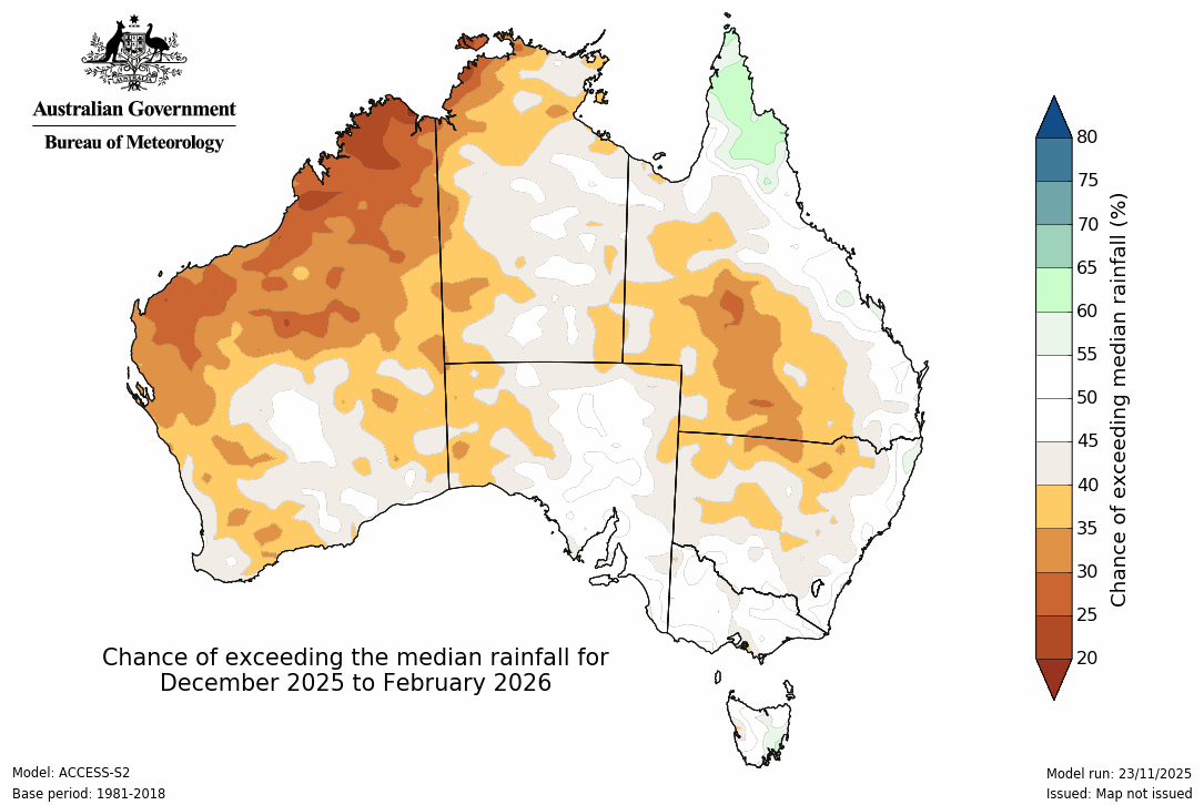
Image: Chance of exceeding the median rainfall this summer. Source: Bureau of Meteorology.

Image: Chance of exceeding the median maximum temperature this summer. Source: Bureau of Meteorology.
One of the reasons for the warm and dry summer outlook, despite La Niña, is the ongoing influence of a negative Southern Annular Mode (SAM) in the Southern Hemisphere. This negative SAM has been in place since early October in response to rare episodes of Sudden Stratospheric Warning above Antarctica during mid to late spring.
A negative SAM during late spring and summer enhances westerly winds over Australia, which can counteract the influence of La Nina’s strengthened easterly trade winds. The current negative SAM phase has indeed been hindering La Nina’s influence on Australian weather in recent months, and this influence may linger into early summer.
Some international long-range forecast models do show signs of La Niña starting to have more influence on Australian rainfall in the coming weeks. This suggests that a breakdown of the negative SAM may allow La Niña’s influence to emerge more clearly into December or January.

Image: Forecast monthly precipitation anomaly for Australia during December, according to the ECMWF SEAS5 model. Credit: Weatherzone.
The outlook for this summer is currently tricky to pin down due to the competing influences of La Niña and the SAM, and uncertainty regarding the future development of the SAM into December.
Meteorologists will be keeping a close eye on the primary climate drivers around Australia in the coming weeks to see how this situation evolves heading into summer. You will find regular updates on the Weatherzone news feed throughout the season.