
IOD reaches new (dry) heights
The strongest positive Indian Ocean Dipole of the last two decades is limiting rainfall in Australia this spring.
The last three months have collectively been the driest on record for some areas of southern and eastern Australia. While many factors influence day-to-day weather systems, this prolonged dry period has been underpinned by something called a positive Indian Ocean Dipole (IOD).
A positive IOD refers to a pattern of sea surface temperature anomalies in the equatorial Indian Ocean. More specifically, it occurs when warmer-than-usual water sits at the surface of the western tropical Indian Ocean near Africa and relatively cool water lies on the eastern side of the Indian Ocean, near Indonesia. This pattern limits the amount of moisture being transported across Australia from the northwest, which typically causes below average rainfall in large parts of the country during winter and spring.
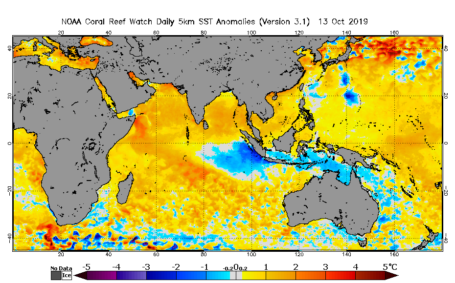
Image: Sea surface temperature anomalies in the Indian Ocean. Source: NOAA/NESDIS
This year's positive IOD event is one of the strongest in recent decades.
Each IOD event is measured using an index that shows the difference is sea surface temperatures on either side of the Indian Ocean. A positive IOD is declared when this IOD index exceeds +0.4ºC for a number of weeks.
During the current positive IOD event, the index has remained above +0.5ºC for the last 11 consecutive weeks and has exceeded +1.0ºC, while also steadily climbing, during each of the last five weeks.
The latest weekly value for the IOD index was a whopping +2.15ºC, measured during the week ending on October 13th. This is the highest value since the Bureau started publishing weekly figures in 2001 and likely the highest IOD index value since at least 1997.
Unsurprisingly, rainfall across southern Australia has been exceptionally sparse during the last three months. July, August and September all ranked among the 10 driest respective months on record for the southern half of the country (south of 26ºS), with data going back to 1900. Last month, when the IOD index values really started to climb, southern Australia registered its 4th driest September in 120 years of records.
Looking ahead, the positive IOD is likely to further limit rainfall in parts of Australia during the rest of spring. However, it's unlikely to last very far beyond that. The IOD typically loses its influence on Australian rainfall fairly rapidly during summer.