
Interesting sailing weather awaiting the 2023 Sydney to Hobart Yacht Race
With the Sydney to Hobart Yacht Race starting off this Boxing Day, the sailors’ attention will switch to the offshore conditions under the ominous reminder of the 1998 race, which took place 25 years ago.
Today, as the yachts make their way outside the Sydney heads and turn south, winds will remain good for the first 100 to 150 nautical miles, as a 10-15 knot northeasterly persists into the evening. As the faster boats make their way further south, east through to northeasterly winds will increase to a strength of about 25-35 knots as the ships travel south of about Bermagui, on the far south NSW coast. The strongest winds will come off the far southeast corner of NSW, into the eastern Bass Strait crossing towards Tasmania overnight into Wednesday.
Mariners will also need to keep an eye on the radar, with warm waters off the NSW coast fuelling thunderstorms over the path south, leading to the risk of heavy rainfall reducing visibility drastically, dramatic and strong winds from varying directions, and the risk of lightning on the open ocean.
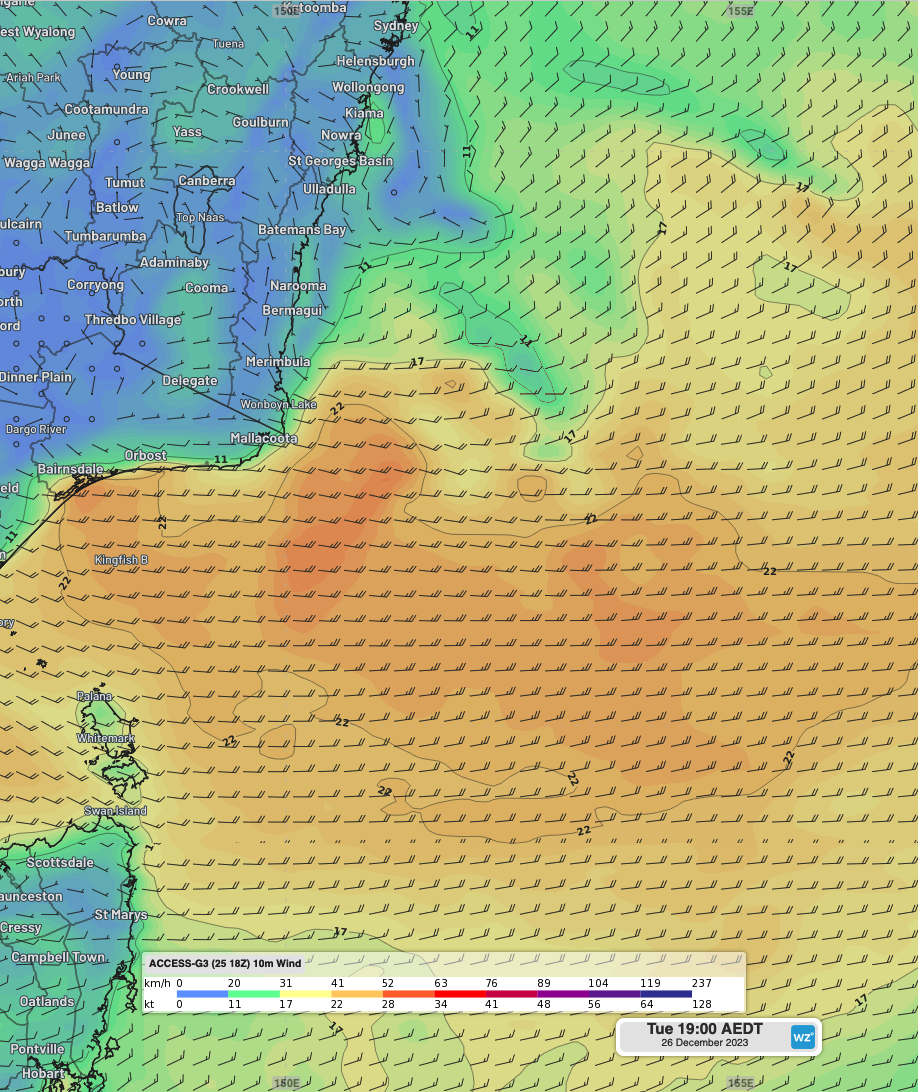
Figure 1: winds on Tuesday 26th afternoon/evening, according to ACCESS-G.
On the second day of the race, Wednesday 27th, the risk of thunderstorms and heavy showers will remain during the morning, extending into parts of the afternoon, before clearing later in the day, as the trough delivering this weather shifts further east.
Winds will be lighter to start, generally around 10-15 knots over most of the course south, from the east to northeast, with a stronger patch of easterlies east of Tasmania in the morning, reaching 20-25 knots. A cool south to southwesterly wind change will develop in the late morning and into the remainder of the day over the region, reaching strengths of 15-25 knots by closure of Wednesday 27th.
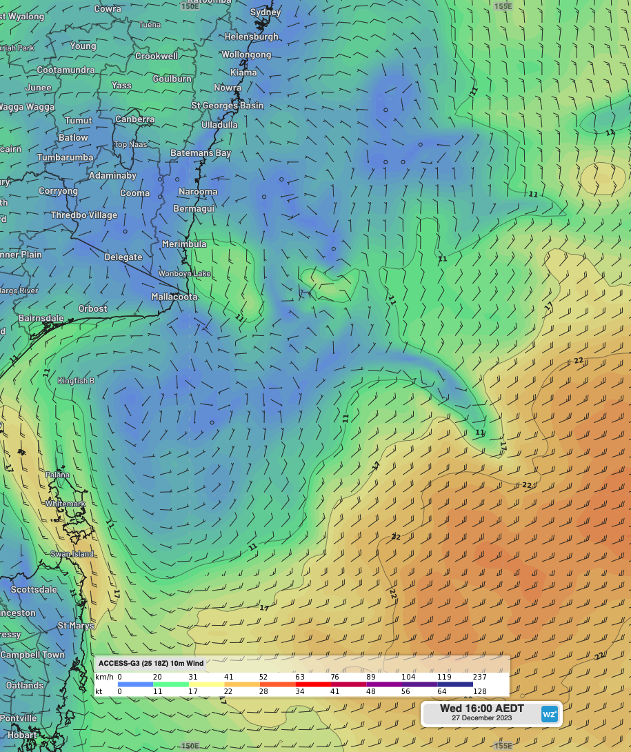
Figure 2: Winds on Wednesday 27th afternoon, according to ACCESS-G.
On Thursday 28th, strong-to-near-gale southwesterlies will blow over most of the sailing course, reaching speeds of 30-35 knots, hindering significant progression as sailors tack into the headwind. Winds will remain quite strong on Friday 29th as well, but tend more westerly, before restrengthening from the southwest on Saturday 30th, with persistent frontal passages working against the progress of some of the smaller and slower boats going into the end of the week and weekend. Brisk, but generally short, showers will also accompany these frontal passages, making for chilly conditions on deck.
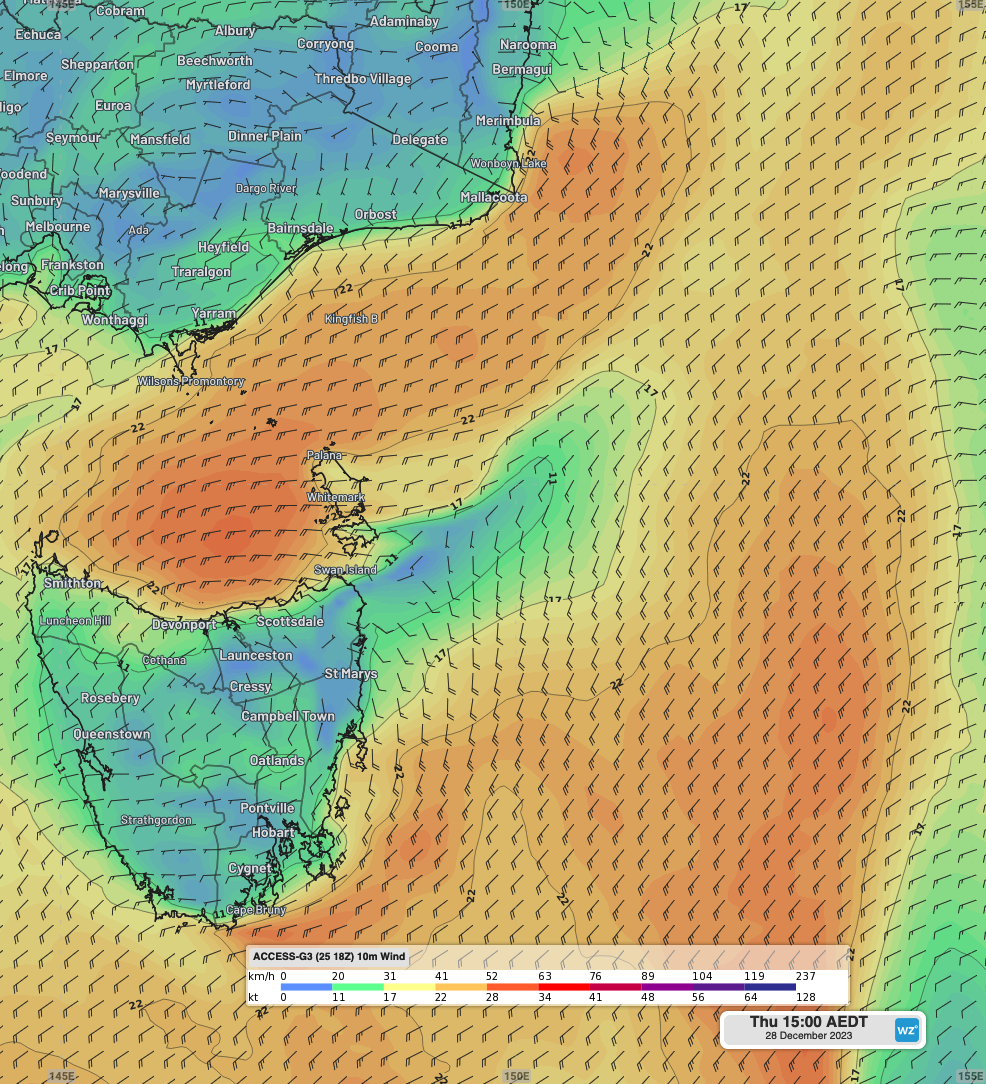
Figure 3: Winds on Thursday 28th afternoon, according to ACCESS-G.
With good winds expected in the first day and a bit of sailing, some exciting racing is expected for the bigger supermaxi yacht, especially as they try to dodge or take advantage of showers and storms in the first 24 hours. The frequent frontal passage expected from Thursday onwards will also make for challenging conditions for smaller boats that will have not yet made the Bass Strait crossing.