
Hurricane Lala – first in a possible train of Pacific storms
While the Atlantic and Caribbean have been quiet so far this hurricane season, the Pacific Ocean is starting to gain a head of steam under the influence of a potent El Niño.
Lala Brings Extreme Rainfall and Damaging Winds to Hawaii
On Saturday August 15, Tropical Storm Lala swept past Hawaii, causing widespread damage as it temporarily strengthened into a Category 1 hurricane.
With its eye passing just south of the Big Island, Lala became only the fifth hurricane to pass within 70 miles since 1957, and brought extreme winds, dangerous surf, heavy rainfall, floods and landslides. There was even some snow high up on Mauna Kea, which, although not unprecedented, is an unusual August feature during a hurricane.
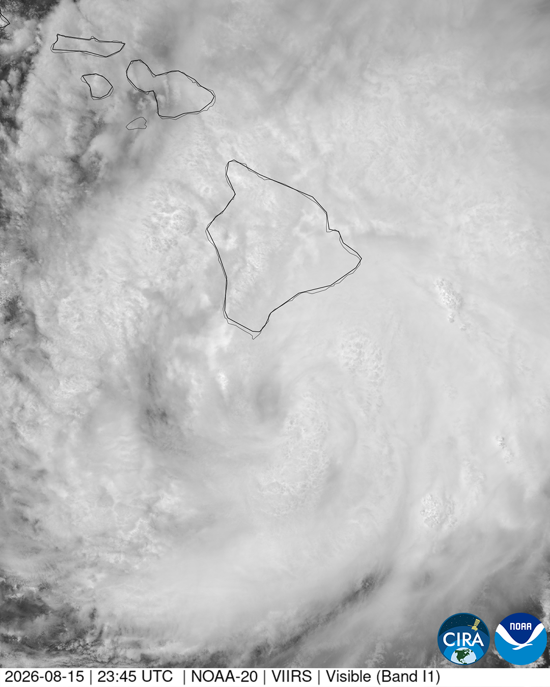
Image: Visible satellite image showing Hurricane Lala passing close to Hawaii in August 15, 2026. Source: CIRA / NOAA-20.
Wild winds and flash floods
As Lala passed by Hawaii, wind gusts of 50–90 mph were recorded on the Big Island, Maui and Oahu, with a 140 mph gust on Mauna Kea.
Meanwhile, torrential rain, augmented by orographic lift over the mountainous terrain, triggered flash flood warnings and emergencies and caused damage to many roads and over 100 homes, some of which collapsed entirely. Laupahoehoe, on the northeastern side of the Big Island, recorded 43.55 inches of rain from the system.
Lala’s center never fully made landfall but as its track was west-northwestwards, parallel with the island chain, it still managed to impact every island.
More tropical systems on the horizon
Although Lala has passed westwards and weakened, further developments are being monitored upstream. As the week wears on, a broad low pressure area is likely to form, and there is a moderate chance that this will develop into a tropical depression by the weekend. If that were to happen, then it may also strengthen and progress west-northwestwards, so Hawaii may not be out of the woods yet.
At the same time, another low pressure circulation in the eastern Pacific, well south of the coast of southern Mexico, has a high risk of intensifying into at least tropical depression by the end of the week. This is on top of an above-average eastern Pacific tropical storm season so far, with 9 named storms and 2 hurricanes, one of which was Category 5 Genevieve.
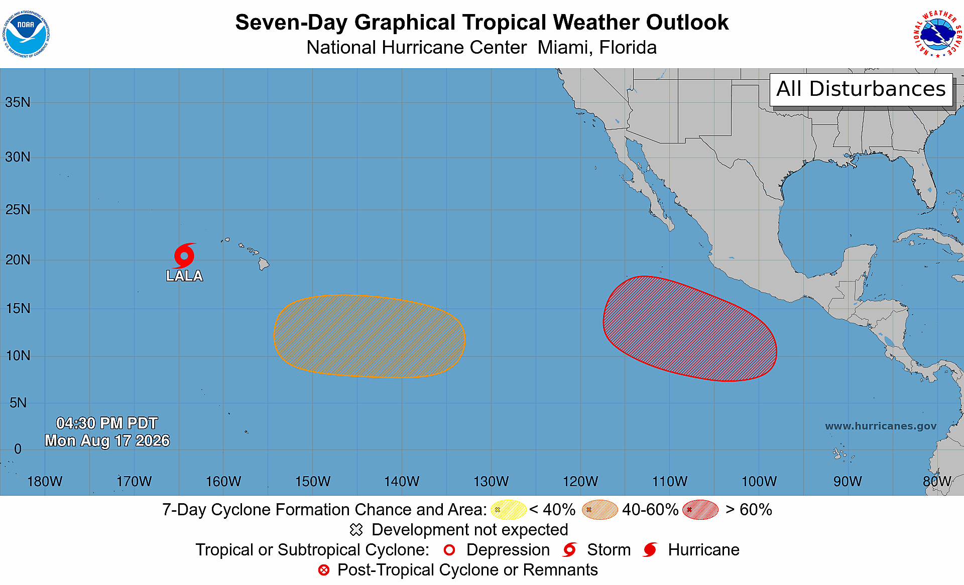
Image: Seven-day tropical weather outlook for the central and eastern Pacific, valid at 4:30 pm PDT on August 14, 2026. Source: NOAA / NHC.
Additionally, the western Pacific has already had a very busy storm season, with 16 named storms and 5 typhoons having formed by August 9, three of those billed as “super typhoons”. This makes it the most active season by this point since 1971. Given current and expected oceanic and atmospheric conditions, an active pattern is expected to continue through the rest of summer and into the fall across the Pacific.
Meanwhile, conditions are much more benign over in the Atlantic. Although the season is far from over, there is little tropical cyclone activity expected through the coming week or so, and thus far there have been only three named storms and no hurricanes. NOAA’s latest outlook for the season calls for 7 to 13 named storms, 2 to 6 hurricanes and 2 or fewer major hurricanes, with less than a 5% chance of above-average numbers.
El Niño’s role
This striking difference across the two oceanic basins bears the hallmark of a strong El Niño, particularly an east-based El Niño event such as that which is rapidly evolving. As expected, conditions have become unfavorable for developments in the Atlantic while encouraging storm growth in the Pacific.
Warm waters provide fuel for tropical cyclones in the form of moisture and energy that power deep convection. But sustained storm growth is contingent on that convection not being disrupted by vertical wind shear – a change of wind speed and / or direction with height. Weak shear lets thunderstorms remain concentrated around the developing cyclone’s circulation center, and allows a nascent cyclone to intensify vertically.
This is the major difference currently being experienced between the two ocean basins. An El Niño episode tends to increase wind shear over the Atlantic by accelerating upper-level westerlies against lower-level trade winds. Moreover, El Niño also usually causes more subsidence of air over the Atlantic, reducing atmospheric instability and making sustained deep convection more difficult.
Meanwhile wind shear decreases across the Pacific through the strongest convection shifting east and forcing changes in the atmospheric circulation. Areas of lower wind shear expand more broadly during a strong El Niño, producing the kind of environment that allowed Lala to approach Hawaii.
With El Niño already very strong and likely to strengthen further, the central and eastern Pacific Ocean could see more tropical cyclone activity in the coming months.