
Huge night of rainfall, wind in NSW: when will this East Coast Low clear?
The powerful East Coast Low continues to lash large parts of the NSW coastline this Wednesday morning after 24 hours of damaging wind gusts and huge rainfall totals.
The stretch of NSW coastline from the Hunter region to the South Coast has been most severely affected, with more than 30,000 residents without power and numerous homes evacuated due to coastal erosion and/or flooding.
The intensity of the storm can be seen on the radar, with bands of rain spiralling towards the centre of the low which was located approximately 75 km southeast of Nelson Bay around 8am.
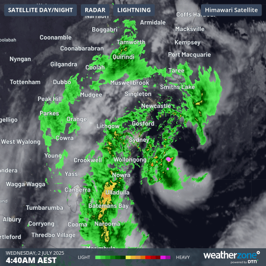
Image: Three-hour combined radar and satellite loop for the central NSW coastline on the morning of Wednesday, July 2, 2025.
Rainfall totals
Some of the heaviest 24-hour rainfall totals in years have been recorded on the NSW South Coast, with widespread heavy falls. Numerous locations received more than 200mm in the 24 hours to 9am Wednesday. Notable totals included:
- 224mm at Ulladulla, which followed 40.2mm the previous day. That’s a running storm total of 264.2mm.
- 217mm at Fitzroy Falls Dam on the NSW Southern Highlands.
- 207mm at Bawley Point Rd.
- 143.6mm at Moruya Airport.
Widespread falls exceeding 50mm across the Sydney basin with both the city and the airport topping 70mm.
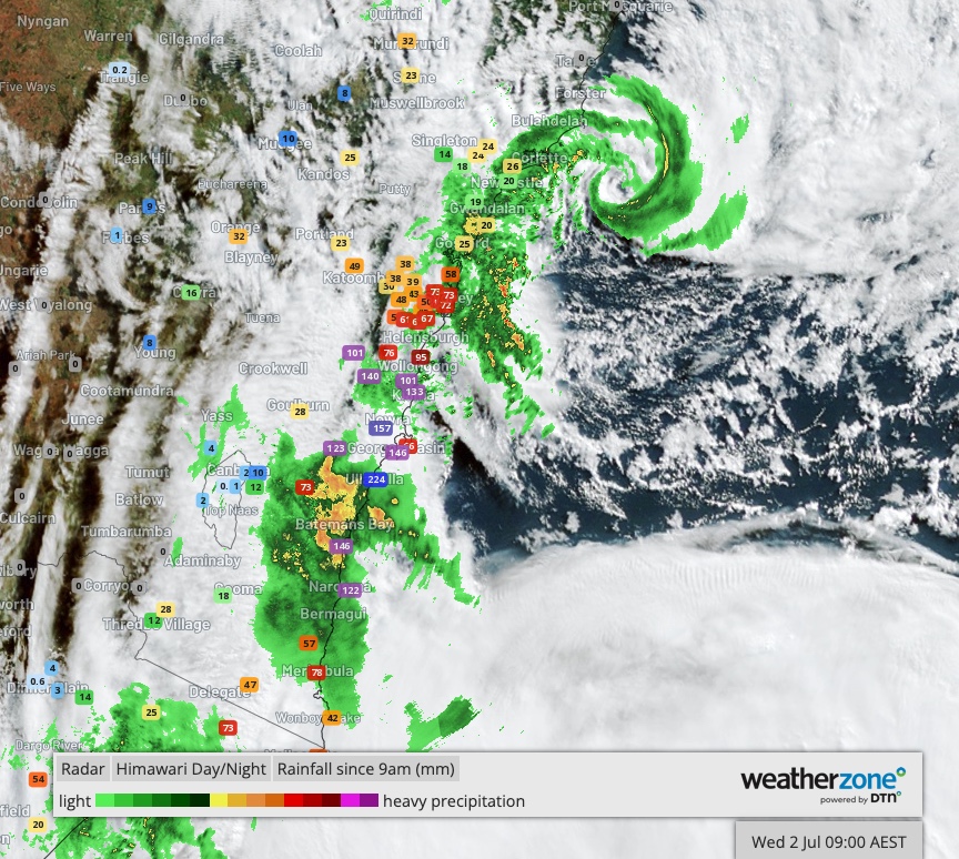
Image: Rainfall observations in the vicinity of the low pressure system for the 24 hours to 9am on Wednesday, July 2, 2025, as depicted on Weatherzone Layers.
Wind gusts
Numerous wind gusts exceeding 100 km/h have been recorded over the past 24-48 hours, with the strongest gusts in the early hours of Wednesday. These included:
- 130 km/h gust at Wattamolla at 5:39am, the strongest in more than a decade at that location in the Royal National Park just south of Sydney.
- 117 km/h gust at Port Botany (Molineux Point) at 5:50am
- 104 km/h gust at Ulladulla at 7:21pm Tuesday, the strongest gust in five years.
- 104 km/h gust at Penrith Lakes on Tuesday evening, the strongest gust there in 12 years.
- 104 km/h gust at Montague Island at 3:30am.
- 102 km/h gust at Sydney Harbour at 5:43am, the strongest in nearly eight years.
- 102 km/h gust at Bellambi at 4:37am
- 100 km/h gust at Ulladulla at 5:43am.
- 100 km/h gust at Kiama at 5:58am.
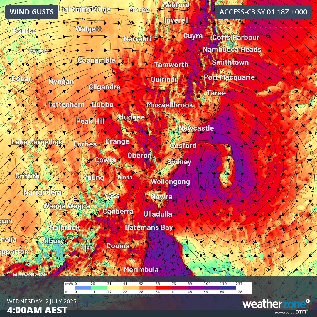
Image: NSW wind gusts at 4am on Wednesday July 2, 2025, which was around the time some of the strongest gusts were recorded.
Waves
Huge swells have been whipped up by this intense low pressure system, whose central pressure dropped 26 hectopascals within 24 hours to 988hPa from Monday into Tuesday.
- Sydney’s Botany Bay registered a significant wave height (the average height of the highest third of waves) of 6.5m and a maximum wave height of 10.6m at 4pm Tuesday, at which point the official buoy stopped recording.
- Port Kembla registered a significant wave height of 6.4m and a maximum wave height of 13m.
- Batemans Bay registered a 12.3m maximum wave height around midnight.
- The buoy off Eden, the southernmost major town on the NSW coast, recorded registered a maximum wave height of 12m at 3am Wednesday.
Large swells will persist until the end of the week, making coastal activities like fishing and surfing extremely hazardous.
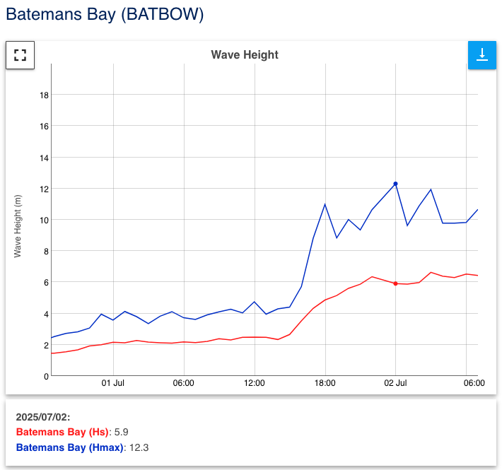
Image: Wave heights at Batemans Bay on July 2. Source: Manly Hydraulics Laboratory.
What’s next?
This remains an intense and dangerous weather system.
The central pressure of the East Coast Low was 986 hPa at 4am AEST on Wednesday, which was 20 hPa lower than it was at 4am on Tuesday. This huge and rapid drop in pressure has contributed to the severity of this system.
Areas of heavy rain, damaging winds and dangerous surf will continue to affect parts of eastern NSW on Wednesday as the low lingers near the coast. Damaging gusts could also extend into parts of southeast Qld. Severe weather warnings are in place for both states.
The low is expected to move away from the coast later on Wednesday into Thursday, which should allow conditions to gradually ease. The weather will be clearer and calmer by Friday and waves will also ease into the weekend.
Please check the Weatherzone warnings page for the latest flood and wind warnings and the NSW SES site for the latest incidents, advice and warnings.