
How's the snow season opening weekend looking?
Two words sum up the likely snow conditions this King's Birthday long weekend as we officially kick off the 2023 Australian snow season: not great.
The good news is that decent snow looks to be coming next week. Also, a very light fall of natural snow dusted the highest elevations of the Aussie mainland resorts this Thursday afternoon, as you can see from the latest live cam (with time stamp) at the top of Thredbo.

Image: Barely a centimetre of fresh snow after more than 70 mm of rain over two days in Thredbo. Source: ski.com.au.
But there's no hiding from the fact that there will be no rideable snow outside snowmaking areas this weekend – and probably not much available even in snowmaking areas.
There's an old saying in Australian snow circles that "Snow in May doesn’t pay" and while that's not always true, it has definitely been the case this year.
At least three significant snowfalls occurred in May, but it has simply been too warm in Australia over the first week of winter to retain all but a few tiny patches of that snow at the highest elevations.
We've written several stories this week at Weatherzone about warm June temps in Australia, and the mountains have been no exception – both during the day and at night.
For example in the 24 hours to 9 am Thursday, Mt Buller saw 97.6 mm of rain on its wettest June day in 42 years, with temps that stayed above 6°C until dawn. That's almost tropical weather for the mountains in June.
A cold front then moved through after breakfast time, dropping daytime temps close to zero, and that's why our higher resorts saw a dusting of snow during Thursday, albeit nothing significant enough to change the overall picture.
So what's next?
Another weak front will move through the Australian Alps on Friday morning, with the chance of some more light but mostly inconsequential snowfalls. But the really positive thing about this front is that it will usher in a few nights of snowmaking weather.
To make snow, you need cold, dry air and that's what we should see over the long weekend as a high pressure system moves over the mountains.
Will the Friday night snowmaking window be long enough to lay down a platform for rideable snow on beginner slopes? It's a race against time, but the resorts might just win it by Saturday, with an even better chance of something on offer by Sunday and Monday.
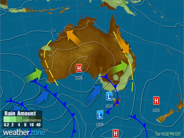
Looking a little further ahead, there's definitely positive news. A cold front should arrive around the middle of next week, with early signs that it could deliver something like 15 to 35 cm of snow. You can see the promising front on Tuesday night's synoptic chart.
For the latest conditions and forecasts for the mountains, your best bet is to check the snow cams and more on our snow page.