
How warming above Antarctica has increased the fire risk in Australia this summer
Parts of three Australian states will have a heightened bushfire risk this summer following rare Sudden Stratospheric Warming (SSW) above Antarctica during spring.
The Australian and New Zealand Council for fire and emergency services (AFAC) has identified western and southern WA, Victoria and inland NSW as key regions that are at risk of heightened bushfire risk this summer.
For some of these areas, the heightened summer fire risk comes off the back of prolonged rainfall deficiencies that have accumulated over the last few years. For other areas, the driving force behind this summer’s heightened fire risk was more a rare SWW event that altered weather patterns over Australia in spring.
What is Sudden Stratospheric Warming (SSW)?
The term ‘Sudden Stratospheric Warming’ refers to a rapid increase in temperatures over one of Earth’s polar regions. This warming occurs around 30 km above Earth’s surface in a layer of the atmosphere called the stratosphere.
When SWW occurs in the Southern Hemisphere, it can disrupt the polar vortex, which is a stream of powerful winds that flow around Antarctica from west to east. SWW events tropically cause the polar vortex to weaken, which allows cold air and westerly winds to spread further away from Antarctica.
A SWW event in spring can cause westerly winds to become more prominent over the southern half of Australia. These enhanced westerlies promote rain in areas of far southern Australia that are exposed to westerly winds, while reducing the likelihood of rain in parts of eastern Australia.
The map below shows how rainfall during spring 2025 compared to the long-term average, with red shading for below average rain and blue for above average rain. You can see that rainfall was above average for western Tasmania and parts of far southern Vic in spring, and below average for northern Vic, much of NSW and some areas in SA and Qld. This rainfall distribution was likely a response to the SWW that occurred in spring.
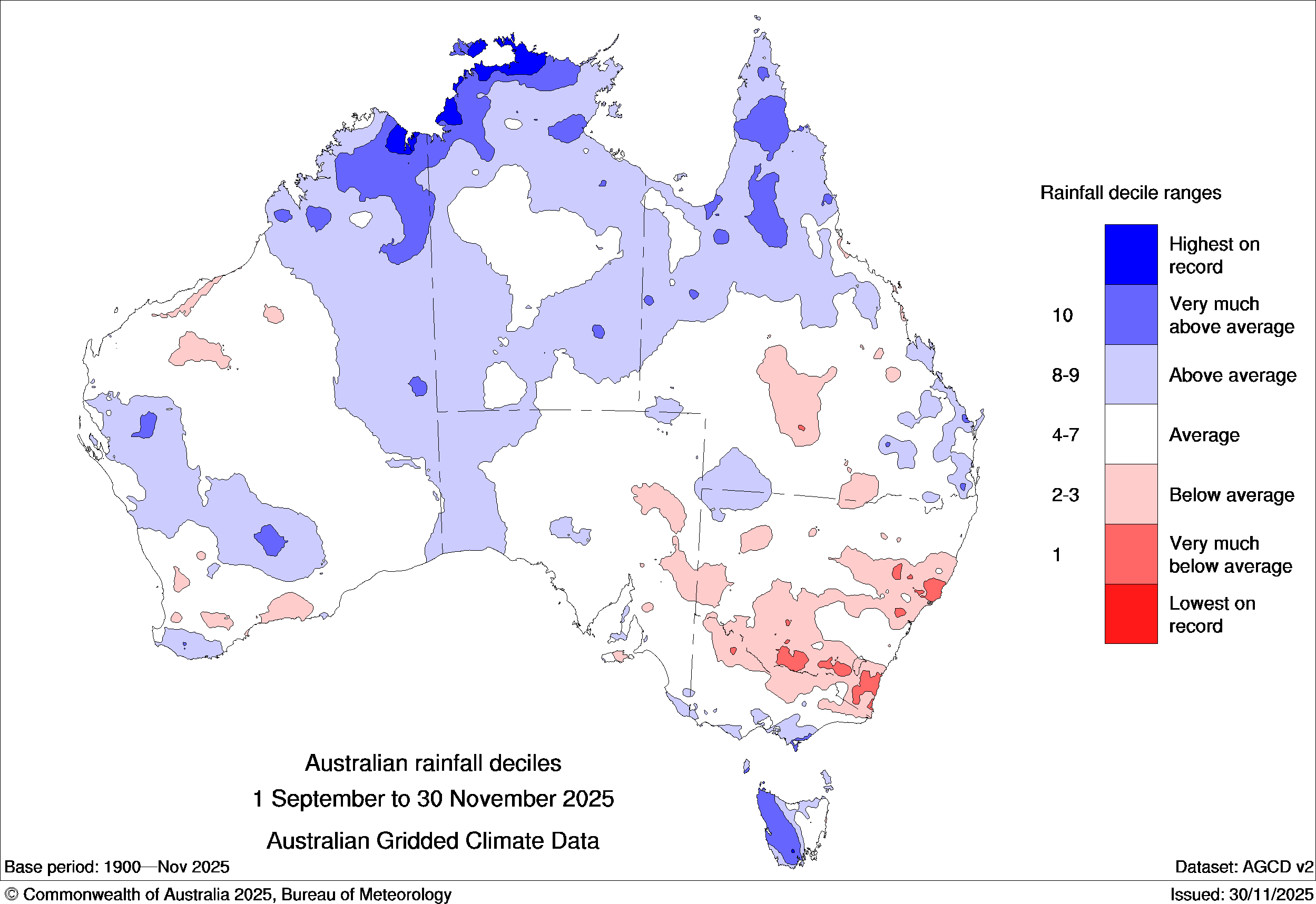
Image: Spring 2025 rainfall deciles. Blue shading highlights areas that saw above average rain and red shading shows areas that were drier than average in spring. Source: Bureau of Meteorology.
What’s expected this summer?
Looking ahead, much of Australia should experience a warmer than normal summer. Rainfall outlooks for the coming season mostly promote wetter than normal conditions for northern and eastern Australia as a result of weak La Niña conditions in the Pacific Ocean, and very warm sea surface temperatures off Australia’s east and north coasts. Elsewhere should see either normal, or drier than normal conditions over the coming three months.
New South Wales, Queensland and the Australian Capital Territory
While the recent SWW brought healthy rainfall to parts of Australia’s southern states, NSW and Qld experienced a number of very hot, dry and windy spells in spring. This has helped dry out the landscape, elevating fire fuel loads for summer.
Hot, dry and windy bursts are likely to elevate fire danger during December for NSW and southern and central Queensland. As the summer progresses, the influence of the SWW should wane, and the effects of very warm oceans off the country’s east coast will increase the probability of healthier rainfall, especially across eastern NSW and Queensland. Western and central parts of these states, which are further from this moisture source, could continue to see a heightened fire risk persist well into summer, with AFAC focusing on central northern NSW as the area with an increased fire risk in their outlook.
Thunderstorm activity is also expected to be above average in eastern Australia this summer. Lightning has the potential to ignite fires, especially across dry landscape, as they have already done numerous times this season.
The ACT is expected to have a near-normal bushfire risk this summer, although abnormally warm and dry weather in spring and above-average temperatures predicted for summer mean the territory could see periods of heightened fire risk in the coming months.
South Australia, Victoria and Tasmania
Parts of southeastern Australia have benefited from decent rainfall in recent months, increasing soil moisture and leading to some fresh vegetation growth. However, the winter and spring rainfall received in 2025 wasn’t enough to offset the severe rainfall deficits that have plagued much of the region over the past three years.
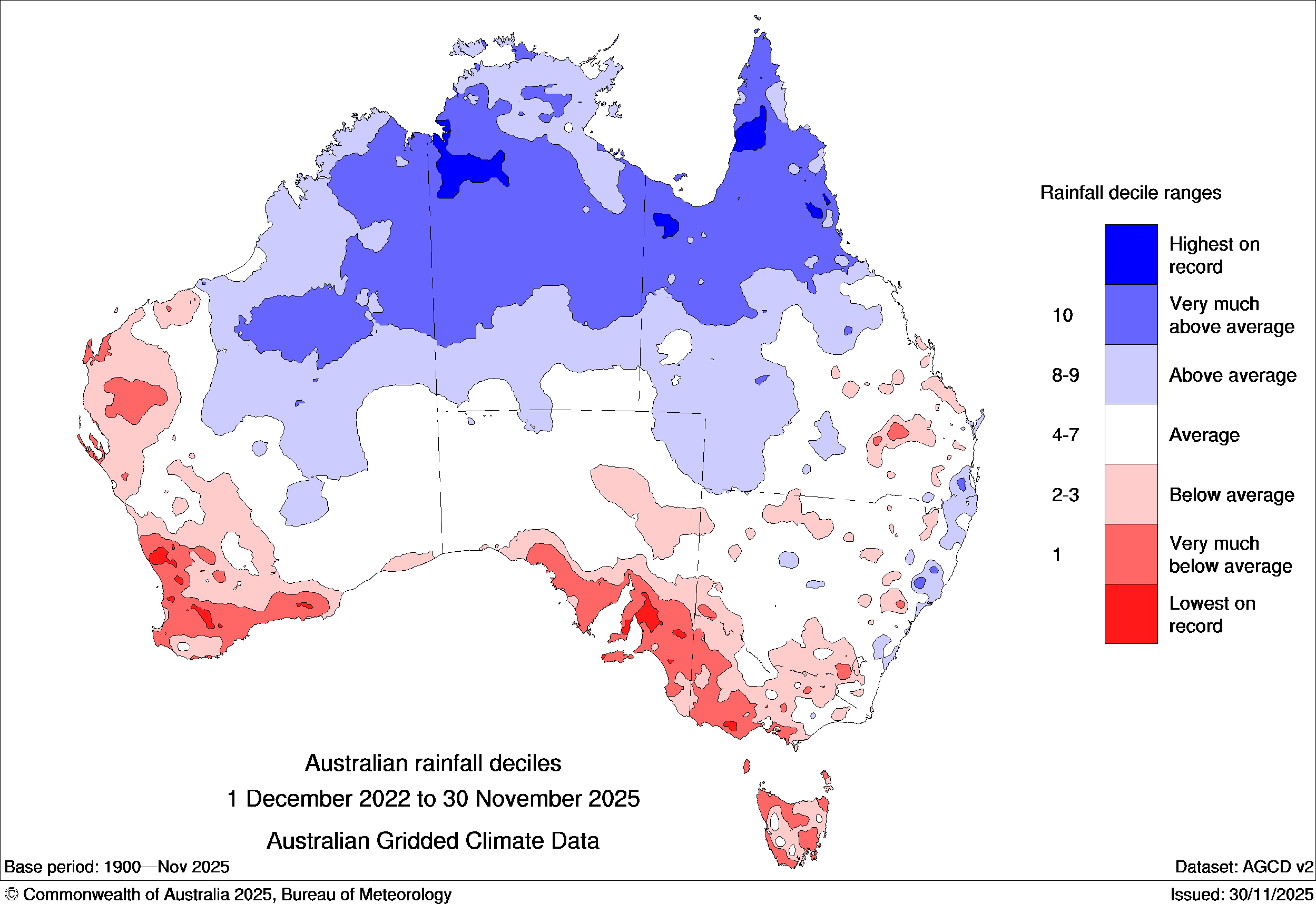
Image: Observed rainfall deciles during the three-year period from December 2022 to November 2025. Source: Bureau of Meteorology.
These lingering rainfall deficiencies, combined with a forecast for warmer than normal temperatures and normal-to-below average rainfall in the coming months, could lead to an increased fire risk over the latter half of summer.
The AFAC outlook highlights broad parts of Vic experiencing this increased fire risk, notably forest and woodland areas of the south-west, Otways, Mornington Peninsula, southwest Gippsland, Kinglake and Yarra Ranges, and Elidon.
While the AFAC outlook keeps South Australia and Tasmania within the normal risk of fire this summer, rapid drying of soil moisture and forest, grass and crop fuels could lead to increasing fire risk late in the season. Notably, parts of SA’s Riverland, North East Pastoral, Mount Lofty Ranges and Mid North regions, and Tasmania’s southwest and southeast, could be at risk if very dry, hot and windy conditions become more prevalent this summer.
Western Australia and the Northern Territory
Parts of western and southern WA are highlighted by the AFAC outlook with an increased fire risk this summer. This follows healthy wet season rainfall during the cooler months of the year, which has enhanced fuel loads ahead of the warmer and drier months ahead. Seasonal outlooks also predict hotter and drier than normal conditions over the coming months. This hot and drying trend will allow fuels to dry, increasing the risk of more significant fires, especially during the mid-to-late summer.
Northern WA and the NT are generally expecting normal risk of fire during the summer months, especially with a wetter than normal outlook for the northern Australian wet season. However, parts of the Pilbara, Gascoyne, WA interior and NT interior could still see periods of increased fire activity following a very dry period during the dry season. This is more likely during the early summer with hot and windy conditions, ahead of intrusions of the Australian monsoon.
What is ‘normal fire risk’?

Image: Peak fire danger seasons across Australia. Source: Australian Institute for Disaster Resilience
The peak fire season occurs at different times of year across Australia.
Northern Australia experiences its worse fire risk across the back half of the dry season, around July to November, when the landscape has dried and strong dry winds blow from the interior.
Much of Queensland and northeast NSW fire danger peaks during spring following the dry winter, and as temperature and thunderstorms ramp up, but ahead of the more wet and humid summer.
Southern Australia typically experiences their worse fire danger during summer with hot and dry airmasses moving over from the interior.
It’s important to note that normal fire risk does not mean no fire risk. Even during a typical fire season, vegetation can dry rapidly, and fire weather can become erratic, leading to impactful fires.
Communities and industries across Australia should remain vigilant throughout summer and stay up to date with the latest forecasts and warnings throughout the season.