
How to check the weather from space, on your phone
It has been 62 years since the first weather satellite was launched into space. Since then, technology has advanced to the point where we can now watch the weather from space, in near real time, on a phone, from the comfort of our favourite couch.
The first dedicated weather observing satellite was launched by NASA in April 1960. It was called the TIROS 1 satellite, which stands for Television and InfraRed Observation Satellite. Below, you can see the first image of Earth that it captured from space.
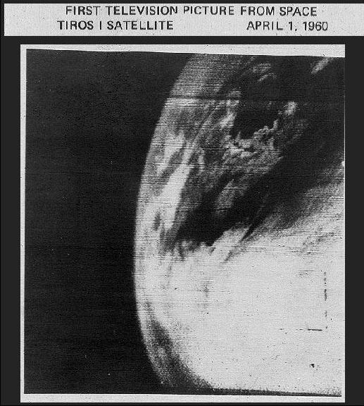
Image: The first photo of Earth from a weather satellite, captured on April 1, 1960. It shows clouds over the northeastern United States and the Nova Scotia area in Canada. Source: NASA
According to NASA, the purpose of the TIROS Program was to “determine if satellites could be useful in the study of the Earth.”
The program was a resounding success. It provided the first ever weather forecasts made from space-based observations and led to the development of more advanced meteorological observation satellites.
Today, a large number of satellites hover above Earth and continually observe our planet’s atmosphere, land and oceans.
The U.S. National Oceanographic and Oceanographic Administration (NOAA) alone operates 16 satellites, including the GOES-16 satellite, which captures high-resolution images of the same region that was seen by TIROS-1 satellite on April 1 in 1960. Below is a comparison between the original TIROS-1 image from 1960 and an image captured by GOES-16 this week.
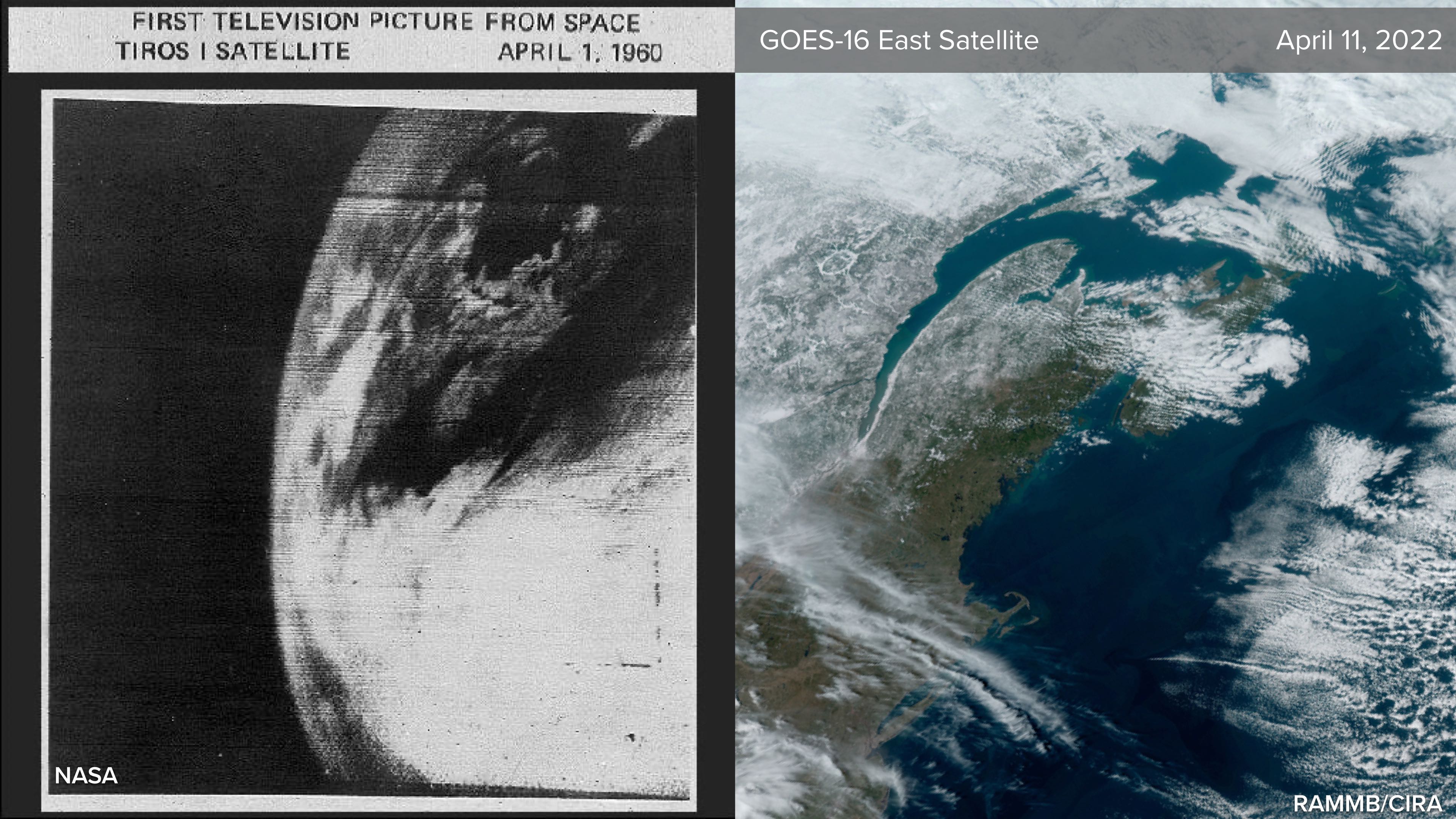
Image: Satellite images of the northeastern United States and eastern Canada captured by the TIROS 1 (left) and GOES-16 East (right) satellites in April 1960 and 2022. Source: NASA and RAMMB/CIRA.
The images above show how much weather observing technology has improved over the last six decades. But, as impressive as the GOES-16 images are, they aren’t as good as it gets.
GOES-16 is a ‘geostationary satellite’ that sits about 35,800 kilometres above the Earth’s surface. Geostationary means that it sits above the same location on the equator and follows the Earth’s rotation, allowing it to capture wide-angle images of the same part of our planet throughout day and night. Geostationary satellites are ideal for tracking weather systems because they always stay in the same place relative to Earth.
However, another suite of Earth observing satellites operate much closer to the surface and provide images of the ground, oceans and clouds in incredible detail. These ‘polar orbiting’ satellites travel past Earth for north to south and pass over or close to the north and south poles. Polar orbiting satellites are ideal for monitoring changes in the Earth’s landscape, such as vegetation and urban development.
The image below shows New York City as seen from the European Space Agency’s Sentinel-2A polar orbiting satellite on April 2, 2022. This satellite operates about 790 km above the Earth’s surface.
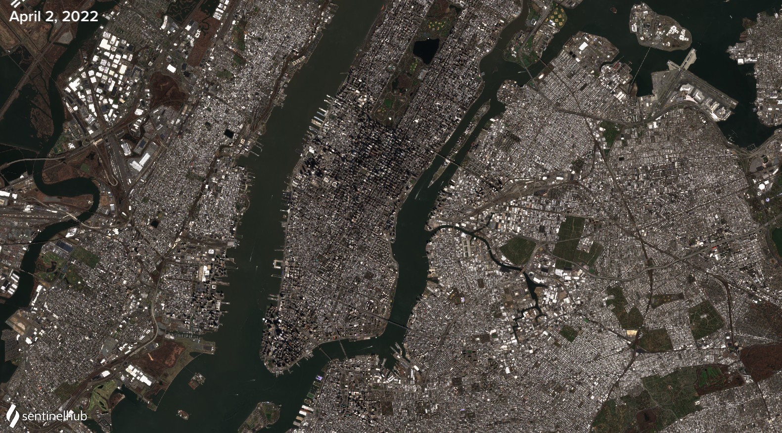
Image: New York City captured by the Sentinel-2A satellite on April 2, 2022. Source: Copernicus/ESA/SentinelHub
Australia’s primary weather observing satellite is the Himawari-8 satellite, which is operated by the Japan Meteorological Agency (JMA). You can access near-real time images of Australia from Himiwari-8 on Weatherzone’s website or mobile app.
The groundbreaking images captured by NASA’s TIROS 1 satellite in 1960 kicked off an six-decade journey of technological progress that now gives you the ability to see what the weather looks like from space using your mobile phone. Pretty neat stuff!