
How the 'brown ocean effect' makes tropical storms more dangerous
The recent close passage of Hurricane Erin came 18 years to the month after another tropical storm named Erin impacted the United States. While this system was only a weak tropical storm when it hit Texas in August 2007, it did something unusual after crossing the coast and managed to become stronger after landfall.
What happened with Erin in 2007?
Tropical Storm Erin developed with minimal strength southeast of Texas in mid-August 2007 and crossed the coast near Lamar on August 16.
Most tropical systems, from depressions to hurricanes, tend to weaken quite quickly as they move inland because they get cut off from their steady source of fuel – the moisture and very warm seas of the Gulf and tropical Atlantic Ocean.
In this case, however, Erin maintained its form as it moved northwestwards across Texas before weakening slightly but then surprisingly strengthening again as it turned north into Oklahoma on August 19.
Erin brought flooding and wind gusts in excess of 80 mph and accounted for 16 fatalities. An eye-like center even formed while over land, and at the time the National Weather Service in Norman, Oklahoma, described Erin as “what amounts to an inland tropical storm” before it started to dissipate over Kansas.
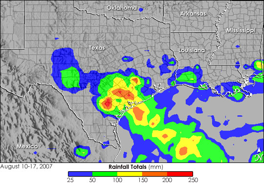
Image: Rainfall footprint of Tropical Storm Erin, showing a satellite-derived rainfall estimate for the period from August 10 through August 17. Source: NASA
How did such an unusual intensification occur over land?
The key to Erin’s intensification over land was a phenomenon called the ‘brown ocean effect’. This has nothing to do with polluted seas or muddy waters. Instead, it refers to saturated and flooded conditions inland, allied with high heat and humidity, acting as a proxy for the usual warmth and moisture provided by the waters offshore.
Texas had already been suffering from regular heavy rain and flooded, soggy land prior to Erin’s arrival; and the ground was also about as warm as the sea from which Erin had arrived.
These perquisites meant that there was a high level of evaporation occurring over land, mimicking the oceanic process that release heat energy (known as latent heat) to a tropical system.
The brown ocean effect has given us an extra category of tropical storms: Tropical Cyclone Maintenance and Intensification Events (TCMI).
Other “brown ocean” storms and impacts
Erin was the first example of such a process to be properly investigated but it is by no means the only example.
In June 2015, for example, Tropical Storm Bill intensified over Texas and Oklahoma in the same manner, following an exceptionally wet May, and only gradually weakened as it headed across the Midwest. Bill eventually caused over $36m of property damage and four fatalities.
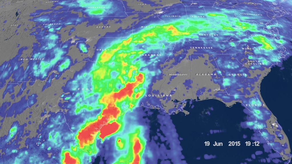
Image: Rainfall produced by Tropical Storm Bill from the time it made landfall on June 16 until June 19, 2015. Source: NASA
Tropical Storm Fay brought destruction to Florida in the middle of August 2008, being blamed for 36 deaths and $560 million in damages, partly due to the 82 tornadoes it spawned along the way. It made four landfalls in Florida on a meandering path north and northwestwards. On its passage across Central Florida on August 19, Fay unexpectedly intensified, with a central eye forming and wind speeds increasing to 70 mph, making it a stronger storm than it had been over the sea. It’s been contended that the moisture of the Everglades and Lake Okeechobee contributed to this strengthening.
One more example is Hurricane Ida from late August 2021, which was Louisiana’s second-most destructive hurricane after Katrina (2005). A tropical wave in the Caribbean Sea on August 23 steadily developed then rapidly intensified into a hurricane on August 27 as it moved northwest across the Gulf. It reached Category 4 strength by landfall near Port Fourchon, carrying maximum sustained winds of 150 mph.
That’s when the brown ocean effect kicked in: Louisiana’s vast wetlands and saturated soil provided sustained fuel for Ida, which remained a Category 4 hurricane for four hours inland and Category 3 for a further four hours before weakening and sweeping away northeastwards and causing severe flooding across the Appalachians and Northeast. This contributed to it being the USA’s fifth-costliest Atlantic hurricane, causing $75.25bn in damages and 92 deaths.