
How does this March's severe weather compare to last year?
Two rounds of widespread severe thunderstorms have already plagued the central and eastern United States this month as strong cold fronts from the West have combined with warm, moist air flowing north from the Gulf of Mexico. March 10-11 and 15-16 have stood out for their large quantity of severe storms. But how is this March stacking up to March 2025?
March 2025 Severe Storm Recap
March 2025 proved to be an active period of widespread severe thunderstorms from the Central and Southern Plains to the Mid-Atlantic. Preliminary reports from the Storm Prediction Center indicate nearly 300 tornadoes were reported across the U.S. during the month and severe hail reports, or hail greater than or equal to one inch in diameter, reached 649. Wind damage reports came in just over 1600.
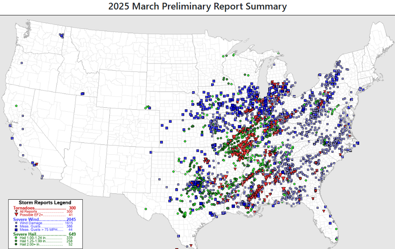
Image: Tornadoes, severe winds, and damaging hail were mainly concentrated east of the Rockies in March 2025. Source: Storm Prediction Center.
During March 14-15, 2025, the first major severe weather outbreak of the month impacted the Midwest and South. On March 14, the Storm Prediction Center had a moderate risk, or level 4 out of 5, for severe storms that extended from Des Moines, Iowa, to Jackson, Mississippi. Nearly 100 tornadoes were reported that day. By March 15, the Storm Prediction Center issued a rare high risk, or level 5 out of 5, for severe storms across Mississippi and Alabama. The Birmingham, Alabama National Weather Service office confirmed that 15 tornadoes tore through central Alabama. March 30, 2025, also had widespread severe storms from northeast Texas into southern Michigan. 45 tornadoes were reported that day along with 465 reports of winds exceeding 50 knots (58 mph).
Similarities in the El Niño Southern Oscillation
As severe storms ramped up last March across the eastern half of the U.S., meteorologists were also monitoring the El Niño Southern Oscillation (ENSO). During the winter of 2025, La Niña conditions, or the cool phase of ENSO was present. This occurs when ocean temperatures near the equator in the Pacific Ocean are below average. By March, there were speculations of ENSO-neutral conditions making a return. ENSO-neutral conditions are present when ocean temperatures in the equatorial Pacific are neither above nor below average.
Similarly, the Climate Prediction Center is predicting that we’ll transition from La Niña to ENSO-neutral conditions going into this April and May. Studies have been conducted on the link between ENSO and spring severe weather frequency across the U.S. In a study that was published in April 2015, John Allen, Michael Tippett, and Adam Sobel found a correlation that the La Niña phase of ENSO could lead to more frequent hailstorms and tornadoes from March through May across the south-central U.S., especially when compared to the El Niño phase. La Niña may help concentrate hot, humid air over the Southern Plains and favor storm formation when strong cold fronts sweep through.
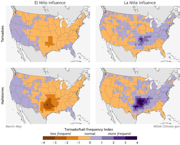
Image: La Niña conditions can contribute to a higher frequency of hailstorms and tornadoes, especially across the south-central U.S. Source: NOAA.
March 2026 Severe Storms
There have already been a few outbreaks of severe weather in March 2026, and this could be a culprit of the La Nina conditions that are present. On March 10-11, the Southern Plains, Midwest, Mid-Atlantic, and parts of the Southeast experienced damaging winds, hail, and tornadoes. There were at least 67 reports of hail equal to or greater than two inches in diameter and 42 tornadoes on March 10. Most of the tornadoes targeted Illinois and Indiana. 43 tornadoes were reported on March 11, mainly across the Mississippi Delta and Southeast.
Another strong cold front swept across the eastern U.S. on March 15-16. From the Mississippi Delta into the Ohio Valley, there were widespread reports of wind damage on Sunday. As the cold front shifted towards the Eastern Seaboard on Monday, there were approximately 78 reports of wind gusts at or greater than 50 knots (58 mph). Most of the strong winds were concentrated across eastern North Carolina, eastern Virginia, Maryland, and New Jersey.
Currently, the Storm Prediction Center has the preliminary tornado reports at 161 for March 2026. Severe hail reports are around 330 with wind damage reports around 1272. Both tornado and severe hail reports are around half of what March 2025 recorded, but wind damage reports aren’t too far off from 2025. March 2025 saw nearly 1615 damaging wind reports and March 2026 is only 343 reports behind this.
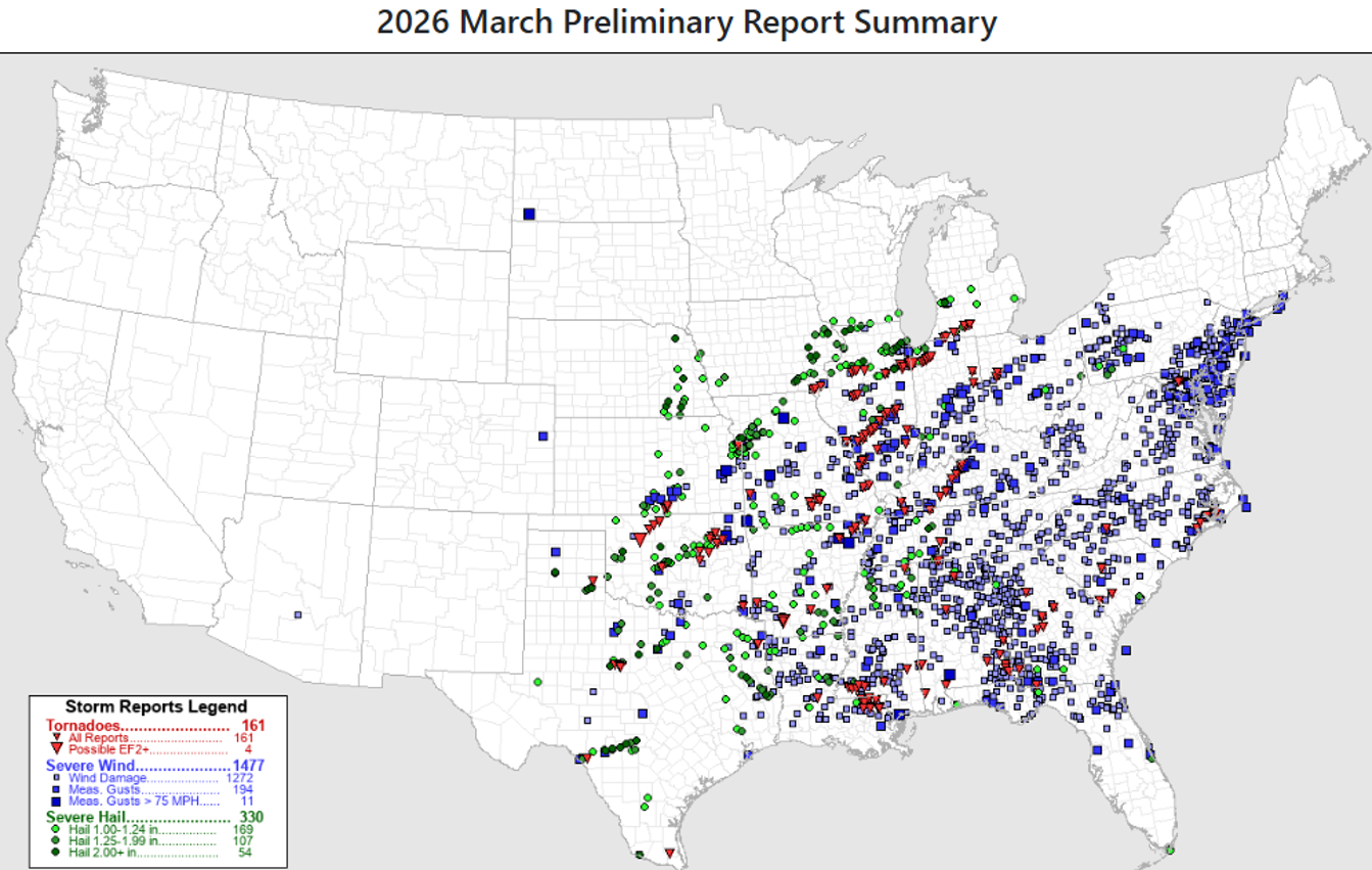
Image: While tornado and severe hail reports are much lower this month as compared to March 2025, the month isn’t over quite yet. Source: Storm Prediction Center.
However, the month of March isn’t over yet and there’s still time to tack onto the severe storm reports. The next system to watch could be moving across the Midwest March 26-27, and depending on the timing of the system, some severe thunderstorms could target Illinois, Indiana, and Ohio.