
How a cold weather system is making the east coast warm and springlike today
Sydney and Brisbane should both reach the mid twenties today, while even places like Bega and Batemans Bay on the NSW south coast should touch a very springlike 20°C – and a large cold weather system is largely to blame for the unseasonally warm temperatures.
That's nowhere near as crazy as it sounds. Indeed it's pretty typical for this time of year in southern Australia. As Weatherzone meteorologist Ben Domensino explains:
"Cold fronts crossing southeastern Australia are always preceded by northerly or northwesterly winds. These pre-frontal winds usually drag warm inland air towards Australia's southern and eastern coasts.
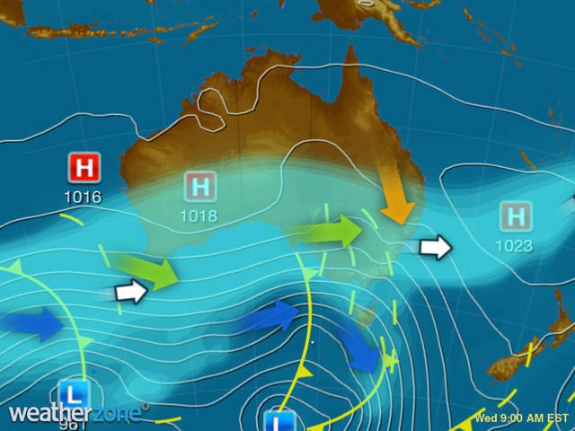
You can see that illustrated really clearly on the Wednesday 9 am synoptic chart. The strong low pressure system well south of the Great Australian Bight is funnelling cool winds along the southern Australian coastline. But warmer air is being dragged down towards the east coast, centred more or less right on Sydney.
That's why the Harbour City is heading for its warmest day of winter 2021 today.
- Sydney's warmest day to date this winter was a maximum of 23.4°C on July 15.
- Its coldest maximum was 10.3°C on June 10.
- Sydney's warmest July day on record was 26.5°C in July 2017. There's a remote chance that could be exceeded today, but at this stage it appears temps will fall a degree or two short.
Meanwhile, it will continue to be windy across southern and eastern Australia today. As Ben Domensino noted yesterday in his piece about the consistently strong and at times extreme winds in Australia this week, wind occurs when air flows between two areas of contrasting pressure.
And right now, the air is flowing nice and quickly between that Tasman High and that Southern Ocean low which you can see on the chart above. Keep up to date with all the wind warnings (and other warnings) here.
There should be some interesting temperature contrasts around this afternoon as Melbourne and Canberra struggle to reach the mid-teens while Sydney basks in temps approaching the mid twenties. We'll keep you posted if any July warmth records are broken on the east coast.
Meanwhile, Sydney and Brisbane and the entire east coast should stay dry and sunny for the rest of the week, although there's just the chance of a brief shower in Sydney on Wednesday afternoon after a spectacular start to the day.
Sydney is in a lockdown mess, but I keep fighting the good weather fight.
— tim ritchie (@timritchie) July 27, 2021
Felt much warmer this morning, and the dawn was spectacular! pic.twitter.com/r6UHvVLOta
Sydney maximums willl return to the teens for a couple of days in the cold air behind the front that should pass on Wednesday night.
Unlike last week when it got seriously cold by local standards, Brisbane will only briefly feel the effects of the cold front on Friday, with temps trending back towards the mid and even high twenties by the end of the weekend and into the new week.
If the 2032 Olympics were being held now (they're scheduled for 23 July to 8 August, 2032, and here's our piece on the likely conditions), everyone would be happy.