
Hot end to the week in NSW
A warm air mass will linger over NSW during the remainder of this week, before a brief burst of rain and storms in some parts of the state early next week.
After registering its wettest October in a decade, NSW hasn't seen much rain in November. Large areas of the state received less than 20 percent of their average November rainfall during the first half of the month.
This predominantly dry weather has also been accompanied by some early-season heat in the past week. On Sunday and Monday, temperatures climbed more than 10ºC above average in parts of western NSW, reaching 43-44ºC in Mungindi, Collarenebri, Walgett, Tibooburra, and Fowlers Gap. A few places in eastern NSW also hit 40ºC on Monday, including Penrith in western Sydney.
Now, another run of warm days is set to round out the week, as more warm air drifts over NSW ahead of a slow-moving low pressure trough.
The mercury is forecast to climb above 40ºC each day from Thursday until Sunday over parts of central, northern or far western NSW. While sea breezes will keep most coastal areas cooler, Sydney's west could hit the high-thirties on Friday.
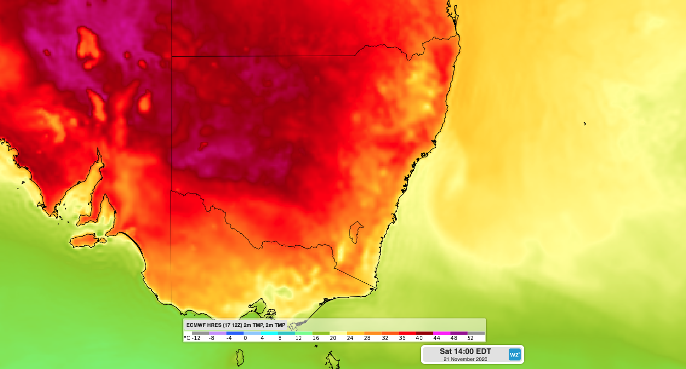
Image: Another hot one on the way for NSW. Map shows forecast surface temperature on Friday afternoon.
Fortunately, this week's heat won't be accompanied by strong winds, so fire danger ratings will mainly be in the Low-Moderate or High categories across the state during the next few days.
However, the hot and predominantly dry weather will help to dry out the abundant grass loads that have grown across NSW this year. This seasonal drying of grass increases fuel loads for fires later in the season.
While there won't be much rain in NSW this week, there should be enough instability in the atmosphere for a few convective showers and thunderstorms over central and eastern NSW on Friday and Saturday. This activity could extend further south along the slopes and ranges on Sunday, although there won't be enough moisture for widespread heavy rain.
The trough responsible for this week's lingering heat over NSW will finally move across the state at the beginning of next week.
The passage of this trough is likely to cause rain and storms in a number of districts on Monday and Tuesday, before drier weather returns from about Wednesday.
Looking further ahead, temperatures will warm up again during the second half of next week as predominantly dry northwesterly winds flow across NSW, ahead of the next low pressure trough.