
Here it comes! Get ready for a wintry weekend
It's the 2nd of July this Friday, the coldest month of the year in virtually every town, city or locality in southern Australian, and a large chunk of the country is going to feel it.
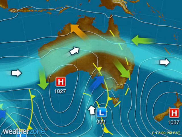
It's all thanks to a cold front which moved through Adelaide this morning and is which is now steadily tracking east, as you can clearly see on the synoptic chart below.
As you can see on the Adelaide observations page, the SA capital was 10.1°C at 8 am this morning, but just 8.4°C at 9 am immediately after the passage of the front.
Adelaide has stayed cool all day, with a temp of just 12.3°C at 2 pm as the city heads towards a forecast top of 13°C. Its coldest day of the year to date was the 12.6°C maximum on June 8.
Meanwhile the front should reach Melbourne on Friday evening, and the VIC capital will likely peak at just 12°C on Saturday.
There's not too much moisture associated with this front, but expect a few showers on Friday evening, as well as a shower or two on Saturday with possible small hail, along with some very chilly winds.
There could even be snow to relatively low levels in the hills and ranges around Melbourne.
â„ LOW LEVEL SNOW FOR THE WEEKEND! â„
— Victorian Storm Chasers (@VicStormChasers) July 1, 2021
If you live in the hills where you're above 700m you might see some white fluffy goodness on the weekend! The wind is expected to increase from t'row for coastal areas in SE SA & Vic. Snow f'cast to down to 800m on Sat & 700m on Sun! pic.twitter.com/GRZNfoAdc5
Canberra is in for a pair of chilly weekend days, even by its standards, with tops of just 11°C . There's only the chance of a shower, so getting wet won't be a huge problem, but staying warm with winds coming straight off the mountains will be a challenge.
Hobart tends to get its chilliest weather from pure southerlies, and because this front has a more westerly and northwesterly flow, the Tassie capital won't get the worst of the wintry weather this weekend.
Expect top of 12°C and 13°C on Saturday and Sunday respectively with only occasional light showers.
Sydney will be blissfully oblivious to the weather experienced in other southern capitals on Saturday, with fine weather and temps likely to nudge 19°C or 20°C as they already have done on Friday.
Sydney should stay dry throughout the weekend, although the cooler airmass in the wake of the front will keep top temps down around 17°C on Sunday.
Meanwhile Perth should be pleasant on Saturday with a top of 21°C, before the next front arrives on Sunday bringing showers and cooler temps.
Brisbane should be showery both days and possibly quite stormy on Saturday with tops in the low 20s.
And Darwin will be doing delightful Darwin things with tops in the low 30s and plenty of sunshine.
For the snow lovers, there's not the prospect of too much snow in this system as it's a little devoid of moisture, but there should be a few centimetres of fresh powder at all resorts by Saturday afternoon.
SHOULD I GO TO THE SNOW THIS WEEKEND (COVID PERMITTING)? OUR WEEKLY GUIDE HERE