
Heavy snow and blizzards to hit the US into this weekend
Two storm systems will move across the northern tier of the United States in the coming days, producing strong winds, heavy snow, and potential blizzard conditions.
Cold air returning after warm spell
It’s hard to think about the return of winter with how warm and rainy the middle of the country has been over the last couple of weeks. But cold air lurking up in Canada will help produce two strong storm systems capable of extremely strong winds and streaks of heavy snow in the coming days. This wintry weather will be produced by two systems.
First system – Wednesday to Friday
The first system moved into the Pacific Northwest on Wednesday, Mar. 11 then into the Northern Plains on Thursday, Mar. 12. The extreme difference in temperature from the Canadian Prairies to the U.S. Central Plains drove extremely strong winds as a low-pressure center deepened near the U.S.-Canada border.
In addition to the wind from this system, a band of moderate to heavy snow formed on the northern side of the storm track, which moved into the Upper Midwest Thursday night and will progress across the Great Lakes on Friday, Mar. 13. The recent opening of the Great Lakes should help to enhance snowfall around the region as well.
With this first storm, around 3-6 inches of snow is expected along the U.S-Canada border with enhanced amounts of 6-12 inches across the Upper Peninsula of Michigan due to lake enhancement.
Some overlap of the winds and snow have resulted in at least reduced visibility if not blizzard conditions. But for most areas, the winds and snow hazards have been separate.
Image: The homepage of the National Weather Service depicts the risks for strong winds across the Plains and Midwest for Thursday night, Mar. 12 and Friday, Mar 13. Source: NWS
Second system – Saturday to Monday
The second system may not have quite the strength in winds that the first did, but it is likely to result in much more snowfall and has a greater risk of blizzard conditions.
This second system will move into the Northern Plains on Saturday, Mar. 14, but a touch farther south than the previous one. The current track has the low-pressure center moving through northeast Wyoming and across northern Nebraska before it continues through Iowa before getting into the Great Lakes on Sunday, Mar. 15, deepening significantly as it does so.
The result should be a wide band of heavy snow across much of the Northern Plains through the Upper Midwest and Great Lakes. Lake-effect snow may continue after the storm passes by for Monday, Mar. 16.
Models are still working out snow totals, but there is a significant risk of seeing 6-12 inches of snow across the Northern Plains, with more than 12 inches across the Great Lakes due to the lake enhancement and lake-effect that follows.
Winds swirling around the system, especially on the western side of the storm track, are likely to increase into the 40-50 mph range with some gusts exceeding that across the Northern Plains and Midwest. There is likely to be some overlap in the strong winds and snowfall, which would result in blizzard conditions, especially on Sunday in the Northern Plains and Upper Midwest, and Monday in the Great Lakes.
Two feet of snow by the end of the week
When combined, the two storm systems are likely to produce widespread areas of 6-12 inches of snow from Montana through Minnesota and Michigan while some areas around Wisconsin and the Upper Peninsula of Michigan may get well over two feet.
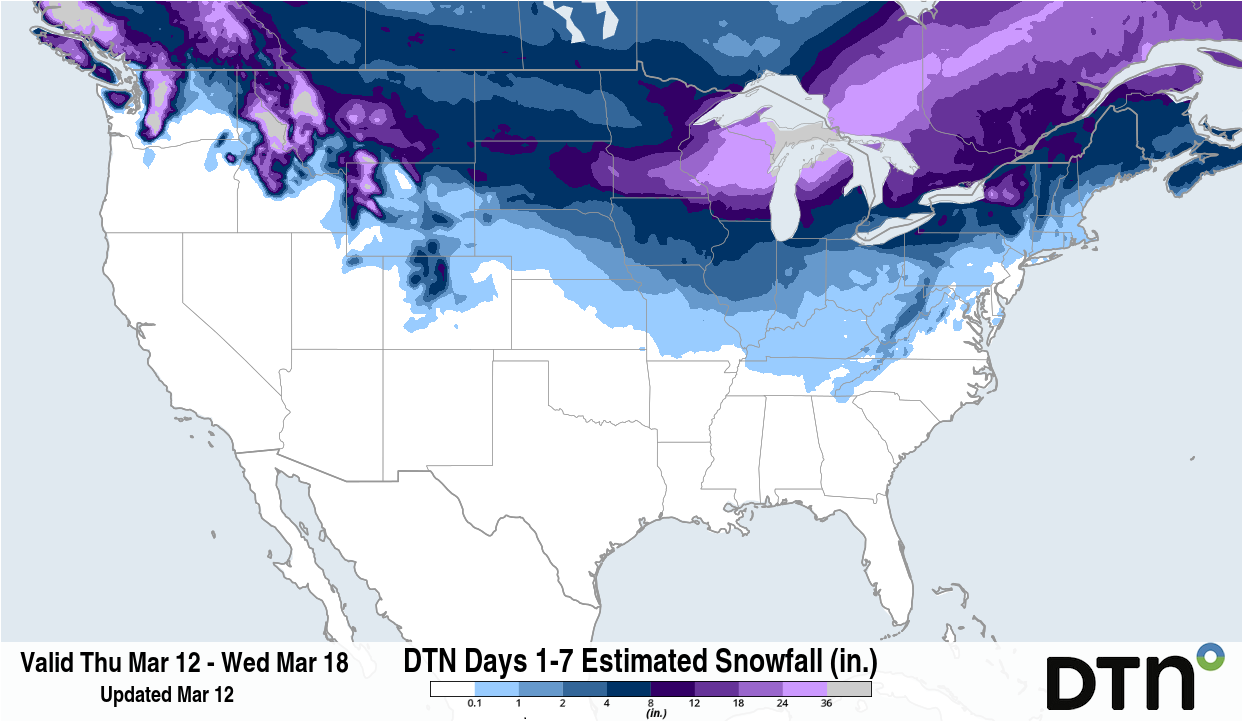
Image: Forecast accumulated snow between Thursday, Mar. 12 and Wednesday, Mar. 18. Source: DTN.
However, adjustments to the forecast are likely to be ongoing as the exact track will determine which areas receive the heavy snow, and which areas get little snowfall or rain. There is likely to be a sharp gradient on the southern edge of the snow bands which could lead to some areas near six inches going down to no accumulation over the matter of 20-30 miles.
After the weekend storm moves through, a burst of significant cold air will spread throughout the country. It will not last long though, as spring-like warmth is forecast to return in short order by the middle of next week.