
Heaviest rain in months in inland Vic, NSW
Rain, and plenty of it, has fallen in parts of central Victoria and New South Wales as a trough moves slowly across those two states.
- Rainfall totals in excess of 50 mm to 9 am Wednesday were recorded in at least 10 locations in northern Victoria, with a reading of exactly 50 mm at Benalla.
- That was the first daily rainfall of more than 5 mm since January in the town of 11,000 residents.
- North of the Murray, falls exceeding 50 mm were recorded in just two NSW spots, but as you can see on the BoM's daily rainfall bulletin below, there were handy falls of more than 10 mm in numerous locations.
- Albury had 18 mm and while that’s not an exceptional total by any means, it was the first decent drop since the city's highest daily rainfall in 160 years back in January.
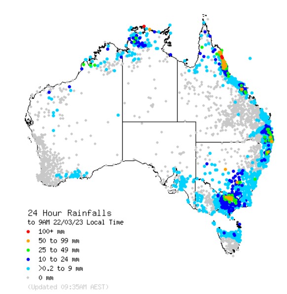
Image: A welcome inland drop. Source: BoM.
This rainfall will be welcomed by locals in inland regions. As you can see on the map above, there was rainfall across virtually the entire east coast over the past 24 hours, as well as in tropical Australia.
That's pretty typical for this time of year, but in inland parts of eastern Australia west of the Great Dividing Range, the rain taps have been largely switched off since at least late January, as La Niña started to wane before being declared officially over by the BoM last week.
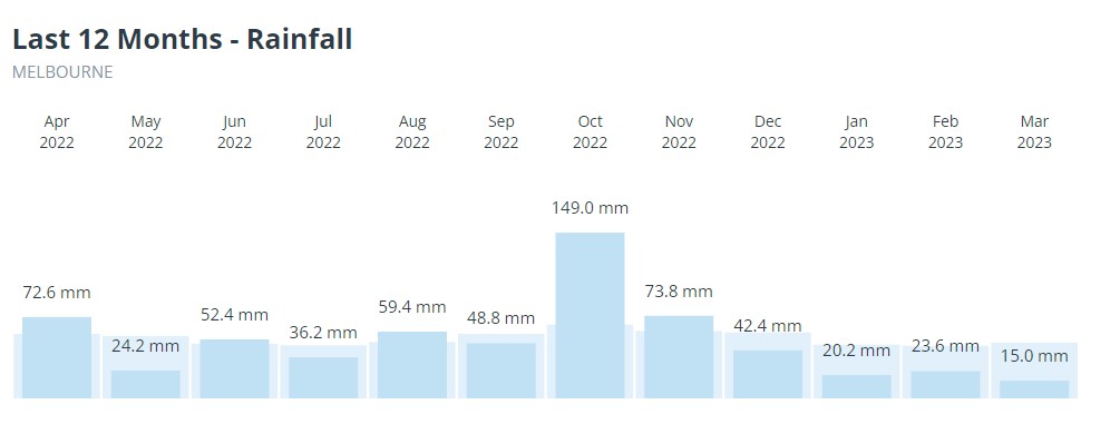
One place that missed the overnight rain was Melbourne.
- Despite moderate falls north and east of the city, most Melbourne suburbs saw less than 5 mm, with the city's official Olympic Park station recording just 1.6 mm to 9 am.
- That means Melbourne has now had just 58.8 mm for the year to date, which is well below the running average.
You can see the recent rainfall deficiency illustrated in the graph below, which also shows the heavy October rainfall that triggered serious floods.
There's only the chance of a light shower or two in Melbourne in coming days, while a rainband remains active in parts of central NSW and is tracking eastwards towards the Blue Mountains, just west of Sydney, as we move into Wednesday afternoon.
There is also a high chance of isolated thunderstorms in parts of Victoria that saw the handy rain overnight, including the Northern Country, North Central, and Central forecast districts. Some storms may be severe, bringing the risk of damage wind gusts and large hail.