
Heat records broken across western, southern US
The recent and ongoing heat wave across the western and southern United States broke a multitude of March high temperature records.
More than 1,500 individual weather stations have recorded new date maxima or new March high temperatures, and 14 states experienced or equaled their all-time hottest March day on record. These included every state between the Pacific to the Rocky Mountains, except for Oregon and Washington, plus several others between the Rockies and the Mississippi River, and even beyond.
Temperatures during the mid-March heatwave were 20 to 40 degrees Fahrenheit above seasonal normals, even beating some April records.
The highest temperatures were recorded along the lower Colorado River corridor on March 20th, with 112°F at Buttercup and Squaw Lake, CA, and at Yuma and Martinez Lake, AZ (subject to verification). Those are not just state-wide record March highs, but for the entire United States, eclipsing the previous highest of 108 degrees set in 1954 at Rio Grande City, TX.
Phoenix, AZ, recorded its first 100°F temperature of the year two weeks ahead of its previous earliest date, and almost six weeks prior to the average date, May 2, while also setting a March record high for the city at 105°F.
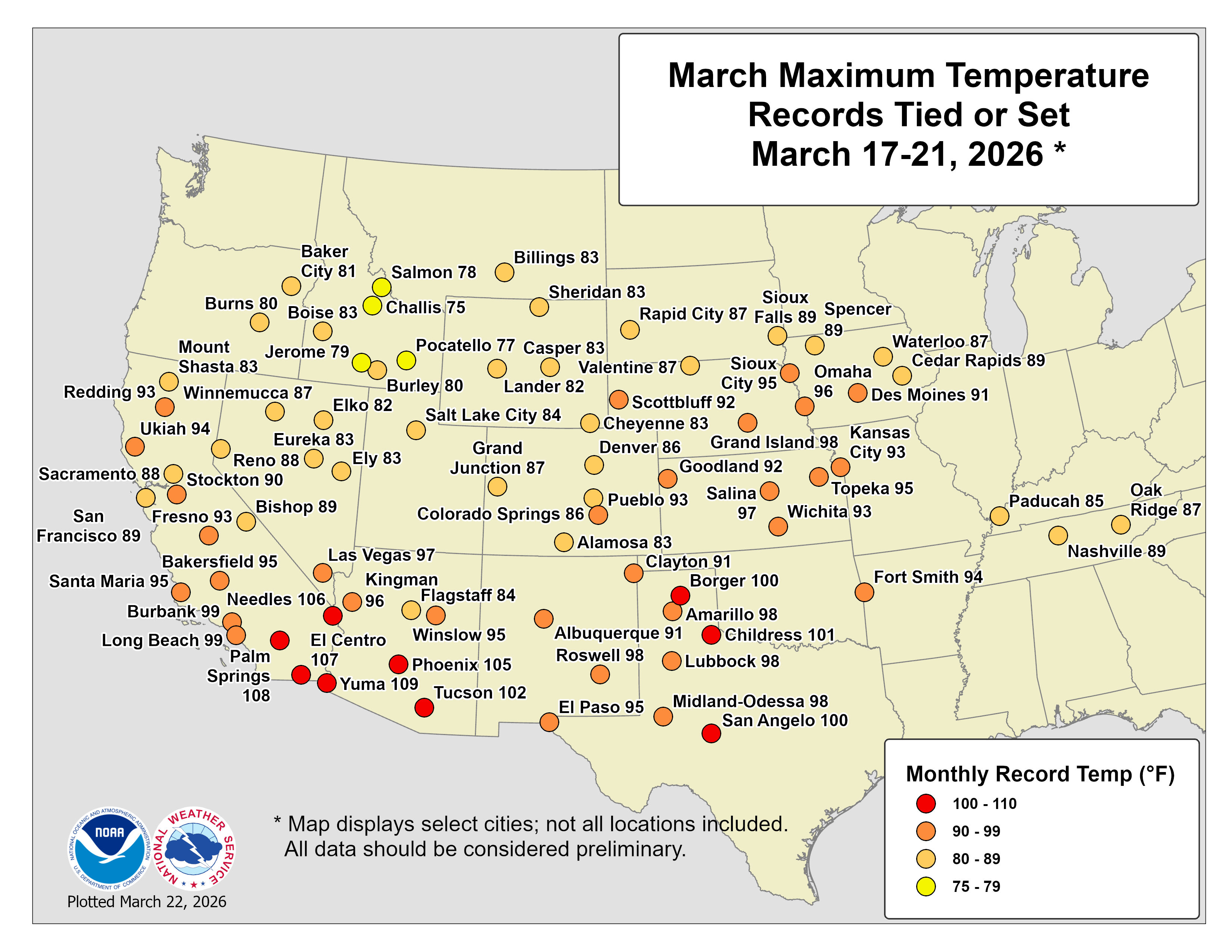
Image: Cities where March high temperature records were equaled or broken between March 17-21, 2026. Source: NOAA / NWS.
Temperatures soar under ‘heat dome’
A so-called ‘heat dome’ developed under a strong, vast and stubborn high pressure ridge that had an intensity more akin to June than March. This heat dome became lodged across the western US, focused particularly on the Southwest, as the jet stream looped much farther north compared with its average position.
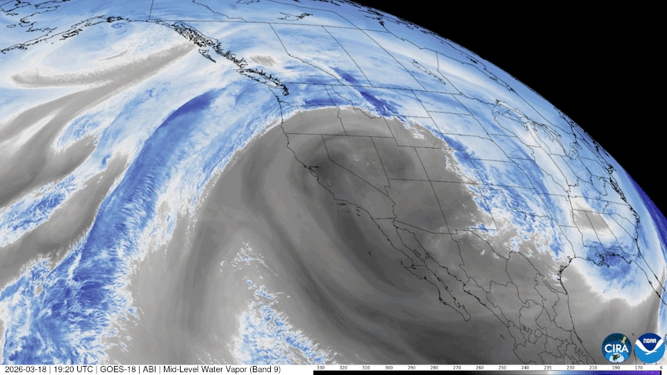
Image: Water vapor image (false color) from March 18, clearly showing the northward loop of the jet stream around the intense high pressure across the Southwest. Source: NOAA GOES-18 satellite.
Heat domes cause unusually high temperatures near the surface in three main ways:
Hot air is forced downwards by the high pressure, and as it descends it warms under compression.
Even as air tries to rise, heat remains trapped beneath the ‘lid’ of high pressure.
Sinking air deters cloud formation, allowing unbroken sunshine to heat the ground, which further warms the air with which it is in contact. Nights become warmer as well, so each subsequent day can start with temperatures at higher levels.
Heatwave impacts
With this excessive heat being so early and so intense, snow pack loss has accelerated and drought is likely to be exacerbated. Aridity and heat will heighten wildfire risks weeks or months ahead of usual.
Extreme heat is also the deadliest form of extreme weather in the US. On average, each year it is responsible for about twice as many fatalities as tornadoes and hurricanes combined.
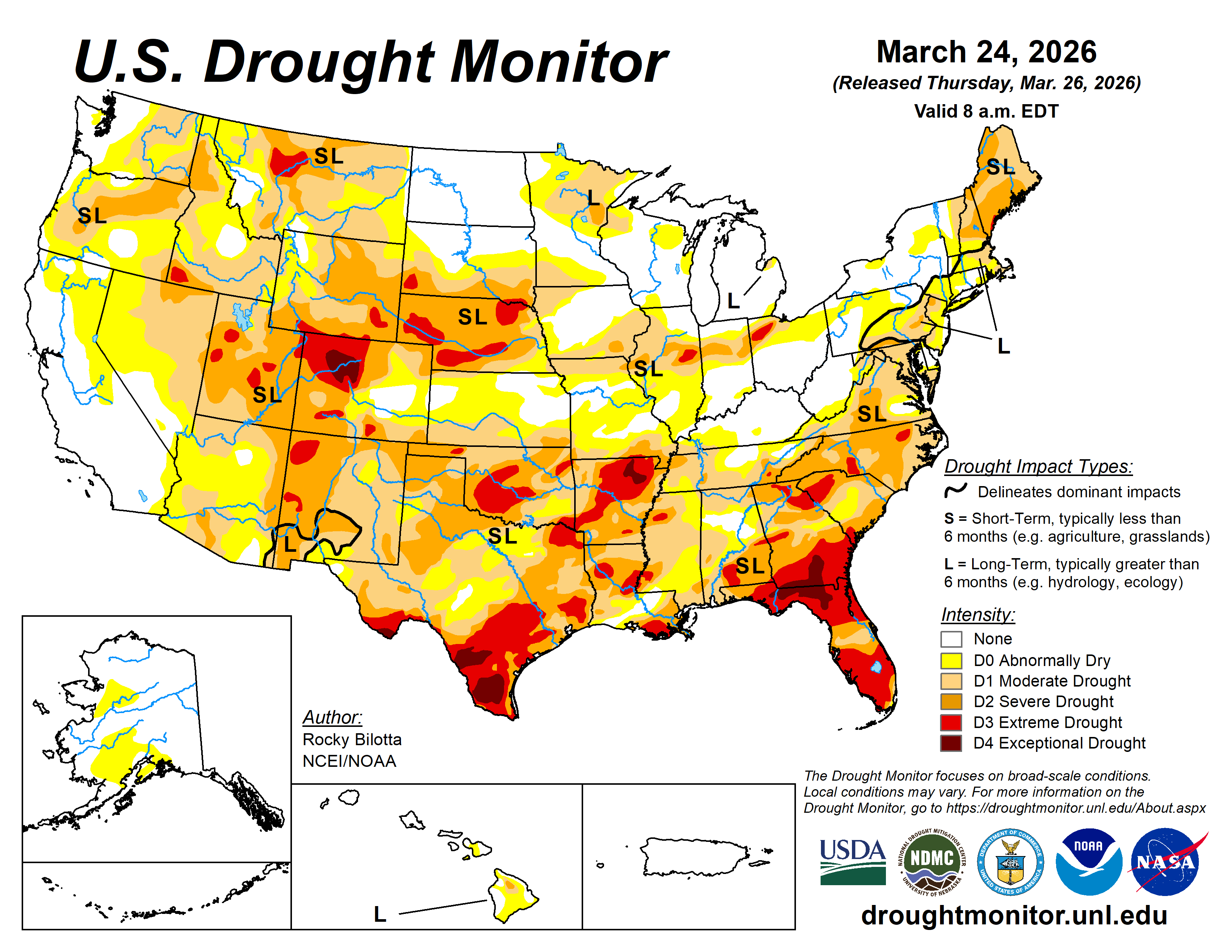
Image: Drought monitor, March 26th. Source: NOAA/NCEI
Change is coming
The strong western ridge will gradually edge eastwards, producing pronounced warm anomalies from the South Central US through the Southeast, Mid-Atlantic and Ohio Valley over the coming week.
This shift in the pattern will allow a low pressure trough to develop across the West, finally bringing relief from the extreme heat, while encouraging an active pattern across the Central and Eastern US, with potential for strong or severe storms from the Plains to the Ohio Valley and Great Lakes.
Heat waves in a warming world
Climate change means that modern heat waves tend to start from a higher baseline. Climate Central suggests that a two-week heat wave of this nature has been made at least 5x more likely by climate change, while scientists at World Weather Attribution have asserted that “events as warm as in March 2026 would have been virtually impossible” without it.