
Gusty front for southwest and gusty low for southeast to start week

While a low spins up off the NSW Mid North Coast today, bringing increasing heavy rain, strong winds and large swell south from about Grafton over the next 36 hours, a gusty front is approaching the southwest.
Rainfall totals for the southwest will be much less than for the southeast but 10mm is expected about the South West and Great Southern between about Bunbury and Albany, with NW wind gusts near 90 km/h predicted Monday afternoon as the front crosses. Swell will also increase to 3-4 metres from the southwest with the front.
Winds will also be at their strongest of the next 48 hours in NSW on Monday, with southerly gusts over 90 km/h likely along coasts from the Central Coast southwards (a Severe Weather Warning is current).
The wind will help drive large swell over the same region, starting easterly on Sunday and tending more southerly on Monday as the low shifts south, lingering close to the coast. Significant wave heights have already risen to 3 metres at Crowdy Head on the central NSW coast, with peak wave heights at 6 metres.
In terms of rain for the southeast, the heaviest falls will be north of Sydney during Sunday before focusing south of Sydney overnight into Monday. Widespread falls of 50-60mm about the coasts and adjacent eastern slopes during Sunday to Tuesday morning are likely with localised falls over 80mm likely for parts of the coast south of Sydney based on current low predictions.
See weather warnings and forecasts for the most up to date information.
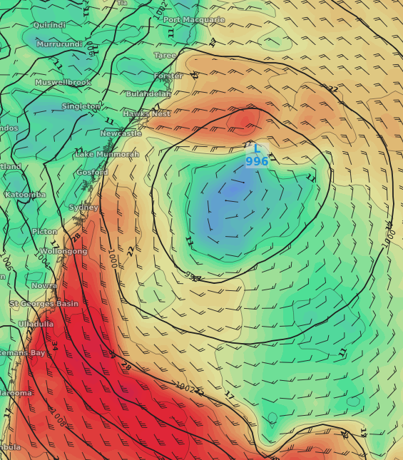
Pressure in hPa (black isobars) and surface wind speed (shading and black wind barbs) for 4pm Monday 27th July according to the ECMWF model.