
Further flooding expected across eastern NSW
Flooding across parts of the Mid North Coast, Hunter and Sydney regions will worsen over the coming days with more heavy rainfall on the way.
The Mid North Coast region of NSW has been battered over the last week with many hundreds of millimeters across many weather stations of the region. This has resulted in major flooding across numerous rivers of the region causing havoc and destruction. The Manning River reached a water level of 5.65m near Taree on Saturday afternoon, rising above the previous flood marks of the 1978 and 2011 floods, but falling short of the 6.0m mark set in 1929. Taree was drenched with 388mm of rain over the span of 72 hours, and has now had it’s wettest March on record.
Other rivers which saw major flooding in the region include the Hastings and Camden Haven rivers, which saw water levels exceed the record flood of February 2013, and record flood of 1978, respectively.
In Sydney, many locations saw rainfall reach the hundred millimeter mark on Saturday, making it the wettest March day on record for stations such as Penrith, Richmond and Canterbury. With all this rain falling into the Sydney Basin, the Hawkesbury River is at risk of reaching flooding levels in excess of the flood of April 1988, with major flooding likely across many embankments.
Warragamba Dam is also under strain after 157mm fell on Saturday, bringing the dam to over 100% capacity and started spilling at about 3pm on Saturday. Overflow of the dam is feeding into the Nepean River, causing flooding in Penrith and surrounding areas.
While the heaviest and most intense rainfall may have passed, a continuation of this deluge, combining with the approach of a deep low pressure trough from the west, will likely lead to further flooding across many parts of eastern NSW.
On Sunday, widespread daily falls of 30-60mm will be possible between Wollongong and Coffs Harbour, with isolated falls reaching 100-200mm possible over the adjacent ranges.
On Monday and Tuesday, the inland trough will begin to interact with the moist onshore flow in the east, possibly bringing the running total since today to 100-200mm across most of eastern NSW, with some locations possibly seeing as much as 400 extra millimeters of rain. All of this is on top of the already astonishing amounts fallen.
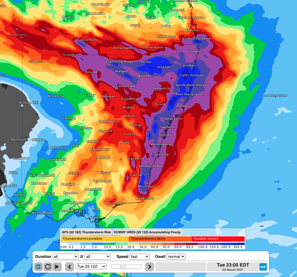
Image: Modelled accumulated rainfall in the 72 hours to Tuesday showing an extensive area will total rainfall in the 100-200mm range, along with parts of NSW seeing totals climb into the 200-400mm range.
With all this extra rain, already flooded areas will not have time to drain and ease before flooding once again. To keep track of flood and general warnings in NSW, visit here.