
Fourth of July 2026 forecast
The United States is preparing to celebrate its 250th birthday this Saturday, July 4. Because of the historic anniversary that also falls on a weekend, celebration plans will be extensive. That makes this year’s weather forecast even more important than usual.
Warm and stormy lead-up to Independence Day
A massive dome of heat and humidity has spread out across the eastern half of the country this week. It has led to extreme stress for anyone going outdoors or without a working air conditioner. Temperatures have eclipsed the 90-degree Fahrenheit mark from California to Maine and all areas south. 100-degree F readings have occurred in the traditionally hot areas in the Southwest, and have also been noted in the Mid-Atlantic on Wednesday and Thursday, July 1-2.
To the north, temperatures have been much milder and have created a zone on the edge of the heat that has produced widespread areas of showers and thunderstorms, severe weather, and bursts of heavy rain throughout the week. From eastern New Mexico north to the Canadian border and east through the Upper Midwest into the northern Great Lakes, we have seen almost continuous precipitation as storms feed on the extreme heat and humidity on the edge of the heat.
But this pattern will be undergoing some changes this weekend, meaning shifting temperatures and precipitation that could make for some interesting weather for Independence Day celebrations.
What will the weather be like on the Fourth of July 2026?
Hot and humid temperatures combined with areas of showers may make this year’s Independence Day celebrations needing a change of plans or timing for some parts of the country.
A pair of small systems will be moving across the country’s north on July 4. One will move through the Northeast and another will move through the Midwest throughout the day.
Rain and thunderstorms
Widespread areas of showers and thunderstorms are forecast between the two systems. As has been the case for much of this week, storms are likely to form clusters both big and small, making shower chances very hit-or-miss.
The most favored locations for areas of heavy rain during the morning and afternoon, which could ruin parades and barbecues, would be from southern Minnesota into the southern Great Lakes. Some areas of the Northeast, Delta, and Southeast and Florida could see some spotty shower and thunderstorm chances through the early afternoon as well.
As the day wears on and the focus turns to evening fireworks displays, storms are likely to push through more of the Midwest into the Mid-Atlantic, with eruptions along the trailing system’s cold front across the Kansas-Nebraska border area back to Colorado. This is where models are less certain with the forecast. If small clusters can run together and grow, there may be more extensive severe weather threats. That is possible across the areas of the Plains and Midwest, but will be more likely in the Mid-Atlantic.
As of July 2, the Storm Prediction Center has outlined an area from about Richmond, VA, to New York City, NY with the best chances for organized severe weather. Damaging winds and heavy downpours will be major threats, especially given how hot and humid the air will continue to be just south of both systems. Some of the rainfall should be waning through the northern Great Lakes back to the eastern Dakotas, across the South and Florida, and maybe in west Texas and eastern New Mexico. But these showers could still impact local fireworks displays.
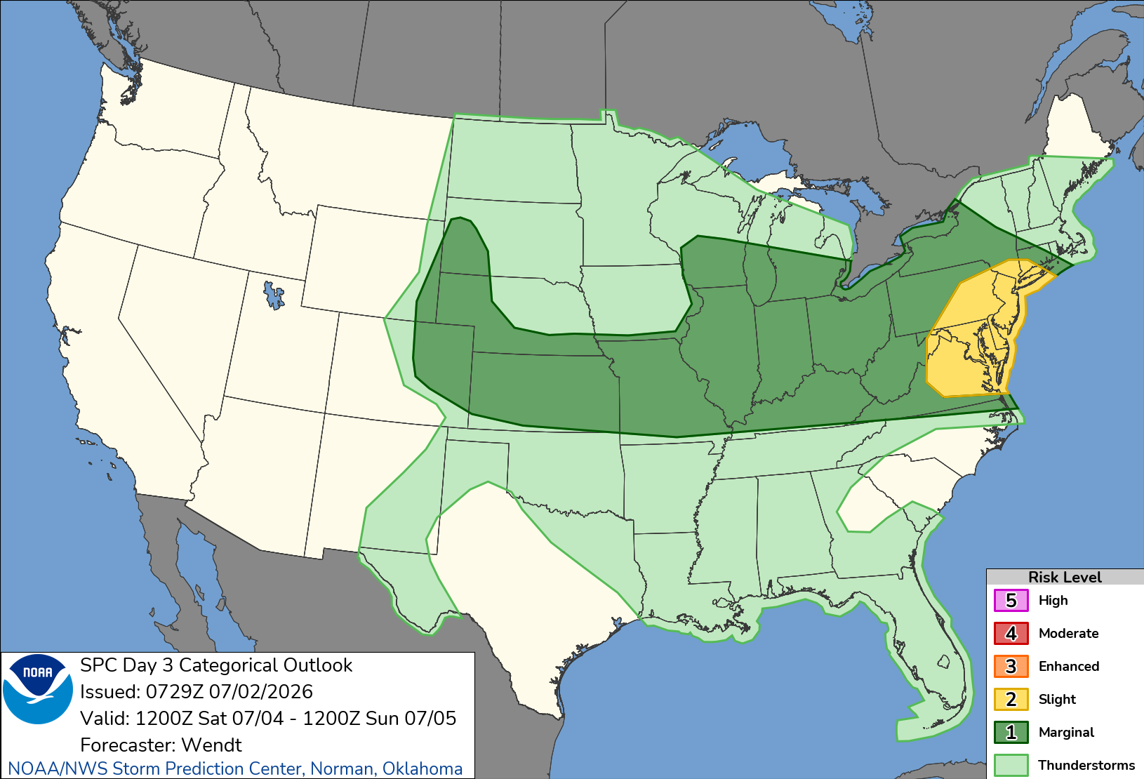
Image: The Storm Prediction Center is outlining a long area of possible severe weather for the Fourth of July. Source: SPC.
Heat and humidity
If the rainfall wasn’t enough of a hazard, high heat and humidity will still be an issue. Temperatures will run in the 90s F from California to maybe Boston and all areas south. This is only slightly farther south than it was earlier this week, but some areas of the Midwest may escape the 90s F, partially due to the ongoing showers and thunderstorms.
In contrast, temperatures will be rising in the west and some 90-degree F readings may make it into some of the valleys in the Great Basin and Pacific Northwest. One more day of temperatures near or over 100 degrees F are forecast across the Carolinas up to New York City and we could see some readings getting close to the century mark from Texas to southern Kansas as well as portions of Arizona and New Mexico.
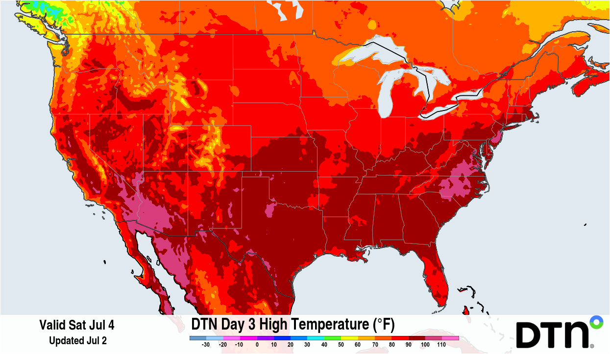
Image: Temperatures will be extremely hot across a lot of the country on July 4, with widespread areas in the 90s (dark red) and some areas crossing the 100-degree mark (pink). Source: DTN.
With these temperatures come dew points in the 70s east of the Rocky Mountains, pushing heat indices well over the century mark and becoming dangerous for vulnerable people to be outside, even in the shade. This heat should continue to ease up as the system drifts southward for Sunday and into early next week, but will still be intense for Independence Day. If rainfall isn’t a problem for your plans, the heat may be.
Best weather for celebrations
The area that will have the best overall weather on the Fourth of July should be in the Northern Plains. A lack of appreciable rainfall and overall summertime temperatures will lead to near-perfect weather to celebrate. If you have the means and the time, travelling to some of the country’s most beautiful National Parks like Glacier or Yellowstone may be the best spots to have a barbecue and watch fireworks this Saturday.