
Flood warnings after heavy SE Australia rain, record August totals in parts of Vic
Extremely heavy rain has fallen across parts of Victoria, South Australia and southern New South Wales and the ACT, with numerous flood warnings in place after a very wet, relatively mild Sunday ahead of a cold front which pushed towards the east coast early on Monday morning.
At least 13 locations in Victoria received more than 100 mm of rainfall in the 24 hours to 9 am Monday, while multiple sites in SA, NSW and the ACT topped the 50 mm threshold.
Illustrating the scale of this dynamic, moisture-laden low pressure system, Canberra (26.0 mm), Melbourne (24.4 mm) and Adelaide (26.4 mm) each received more than 20 mm on the same day for the first time since 2008.
This strong weather system has also produced extremely strong wind gusts across a wide area, with a strongest gust of 130 km/h at Thredbo Top Station on Sunday’s afternoon.
Let’s break down some of the notable wind and rainfall observations on a state by state basis for the 24 hours to 9am this Monday, August 10.
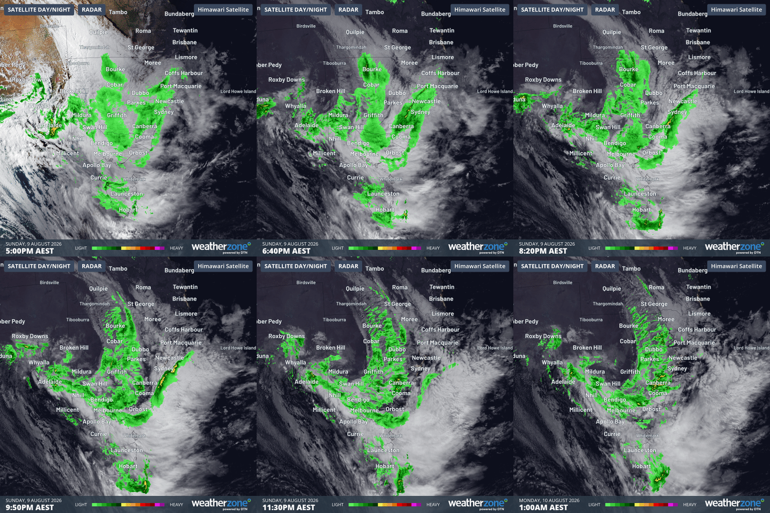
Image: Combined satellite and radar loop for SE Australia for the eight hours to 1 am (AEST) this Monday, August 10, 2026. Source: Weatherzone.
Victoria
At least 13 locations in the state’s northeast recorded huge rainfall totals of 100 mm or more in the 24 hours to 9 am Monday. Notable readings included:
- 165.6 mm at Mt Buffalo Chalet, a record daily total for August
- 159.0 mm at Handcocks (a rain gauge north of Mansfield)
- 129.0 mm at Strathbogie North
- 67.2 mm at Wangaratta, the heaviest daily rainfall in more than eight years in the NE Victorian city
As you’d expect after such heavy rainfall, numerous flood warnings are in place, including moderate flood warnings for the Kiewa, King and Ovens rivers – all of which drain parts of the Victorian Alps. Please check the Weatherzone warnings page for the latest updates.
Melbourne’s 24-hour rainfall total of 24.4 mm was much lighter than other parts of the state, but it was still the city’s wettest day of 2026 to date, and rain continued to fall throughout Monday morning, although the heaviest band of moisture is gradually moving east of the city.
Wind gusts were also brutal in the Victorian high country, with a gust of 120 km/h at Mt Hotham around 6:30 pm on Sunday.
South Australia
In her story on Sunday, Weatherzone meteorologist Ruby Stevens said Adelaide would likely receive around 30 mm throughout the day, and the city’s eventual total in the 24 hours to 9 am Monday was 26.4 mm.
That brought Adelaide's running August rainfall tally to 52.2 mm (long-term monthly average 61.1 mm). After January started with no rainfall for the entire month, Adelaide has recovered well in 2026, recording well above-average rainfall in May, June and July.
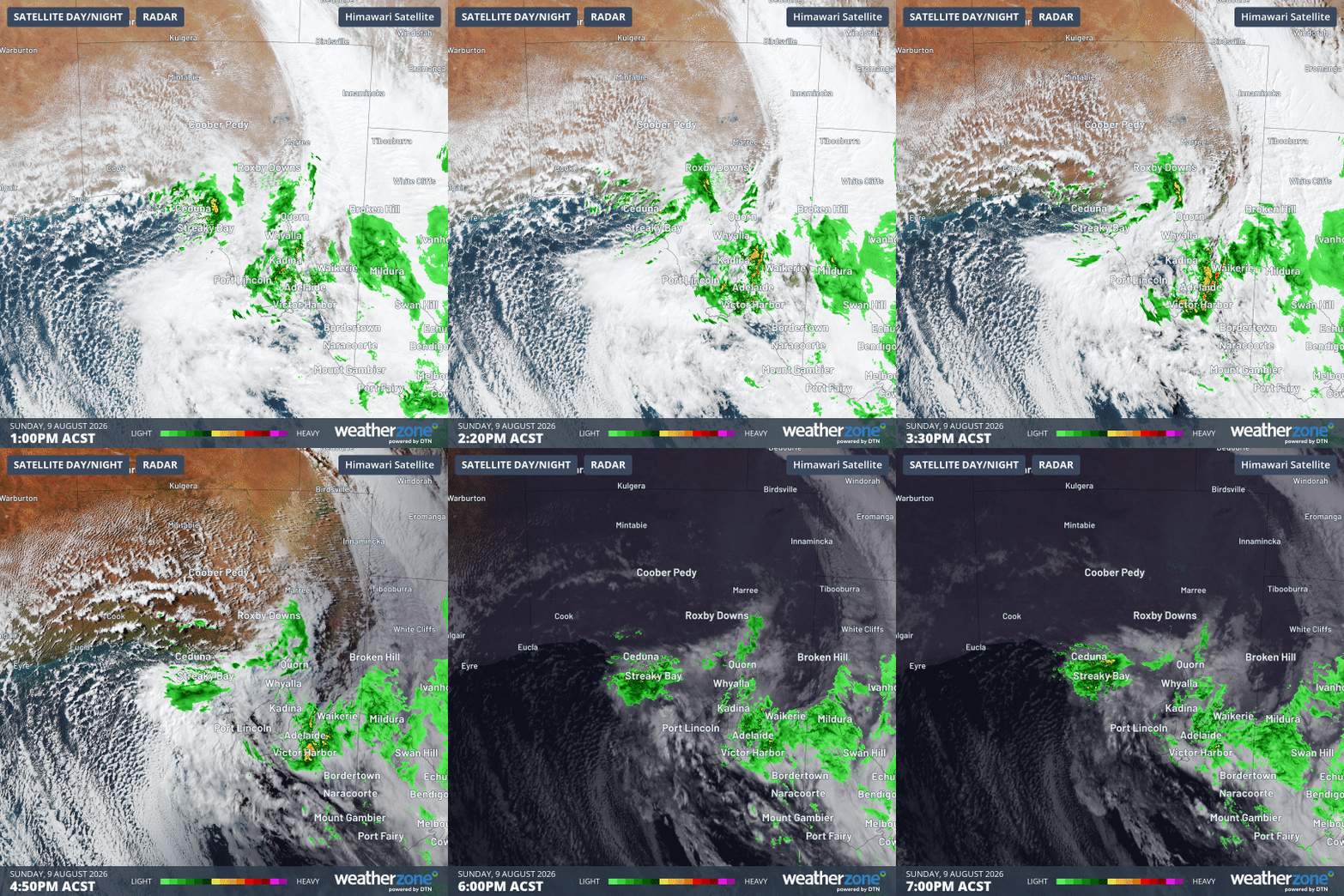
Image: Combined satellite and radar loop for South Australia and nearby areas for the six hours to 7 pm (ACST) on Sunday, August 9, 2026. Source: Weatherzone.
Many SA locations received much heavier rainfall than Adelaide in the 24 hours to 9 am Monday, especially in the Adelaide Hills, and also in the Flinders and Mid North forecast districts. These included:
- 84.0 mm at Wirrabara Forest, near Port Pirie
- 81.0 mm at Blinman, in the usually arid Flinders region
- 70.6 mm at Coromandel East (Ackland Hill), about 20 km SE of the Adelaide CBD
- 69.2 mm at Hope Valley Reservoir, around 12 kilometres NE of the Adelaide CBD
Meanwhile, wind gusts exceeding 80 km/h were recorded at multiple SA locations, some of them a long way from elevated or coastal locations where the strongest gusts are typically recorded in wintry weather systems.
These included gusts of 83.3 km/h at both Coober Pedy and Roxby Downs in the SA outback.
New South Wales/ACT
Handy falls of 10 mm or more were recorded across much of NSW, especially west of the Great Dividing Range. But as mentioned, the heaviest falls in the 24 hours to 9 am were in the state’s south. These included:
- 84.0 mm at Thredbo and 61.2 mm at nearby Perisher Valley
- 81.4 mm at Long Plain in the north of Kosciuszko National Park
- 74.6 mm at Tooma Dam on the northern flank of the Snowy Mountains
- 63.8 mm at Bendora Dam, one of Canberra’s water catchment reservoirs
What next for this weather system?
It’s considerably cooler on Monday across the southeastern mainland than it was on Sunday, and while showers persist across a broad area, most locations are seeing lighter rain than they did on Sunday.
Gippsland is one exception, with steady rain this Monday as winds whip around the low which is now centred over eastern Bass Strait.
In the high country of NSW and Victoria, heavy snowfalls appear to be set in for most of the day. This will please snow enthusiasts after most of the precipitation that fell at the ski resorts on Sunday was the four-letter word known as “rain”.
Some snow showers could also occur further north on the highest parts of the NSW Central Tablelands this Monday.