Fires rage as NSW sears
Fires have become out of control in central NSW as the region sees its worst bushfire conditions since Black Summer.
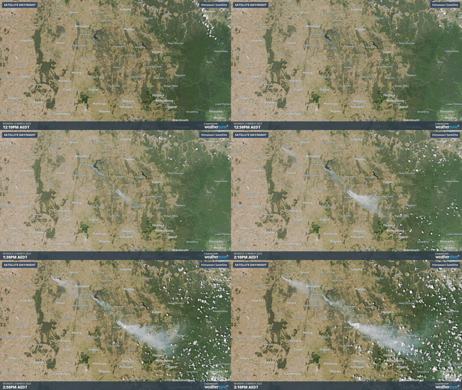
As of 4pm AEDT, two bushfires were at emergency levels:
- One near Tambaroora, located about 50km north of Bathurst
- Another near Cranbrook, roughly 20 km south of Dubbo
Today’s hot and windy weather has produced Bathurst’s worst Fire Danger Index (FDI) readings since the Black Summer bushfires of 2019-20. This afternoon, the region has seen the mercury sitting in the high thirties, humidity in the teens and winds gusting above 60km/h.
You can monitor all active fires across NSW through the RFS website or the ‘Hazards Near Me’ app.
This air tanker was earlier seen at the Alpha Road Fire at Tambaroora, dropping pink fire retardant to slow the blazes’ spread.
With hot and dry conditions affecting NSW, firefighters are working to contain over 40 fires. Crews are being supported by aircraft, including large air tankers. This footage from earlier today shows the #NSWRFS LAT “Marie Bashir” working on the Alpha Rd Fire at Tambaroora. pic.twitter.com/2Ub3t9o9CW
— NSW RFS (@NSWRFS) March 6, 2023
The smoke plumes from these fires can be seen easily by satellite as northwesterly winds fan the flames. You can see the rapid development of these blazes in as little as three hours of heating and drying.

Today’s burst of late-season heat has also caused temperatures to soar along the NSW coast, with parts of Sydney enduring their hottest March day in decades. Some of the hottest locations for far have been:
- Sydney Airport has topped the list reaching 40.6°C, its hottest March day in 40 years. It is also the highest March temperature recorded in the Sydney Basin for 25 years
- Badgerys Creek reached 40.4°C, its hottest March day in more than 27 years
- Penrith has seen its hottest March day in 25 years as the mercury pipped 40°C
Virtually the whole Greater Sydney region, including the Illawarra and Central Coast is now sweating through their highest maximum temperatures in just over 2 years. Temperatures are still on the rise for some, so more records could tumble later this afternoon.

In the Hunter region, both Scone and Murrurundi Gap have seen wind gusts of 69km/h with humidities as low as 6%, easily warrenting extreme fire danger ratings.
On Tuesday, temperatures won’t be as hot as today, but west-to-northwesterly winds could be just as strong as a dry cold front sweeps over the state. To see the latest warnings and forecasts, visit our warnings and NSW pages.