
Fire Risk intensifies next week
A low pressure heat trough moving across from central Australia over the upcoming days will bringing warm, dry, and windy conditions to the southeast, increasing Fire Danger Ratings across the eastern states.
On Sunday Fire Danger Ratings will be high across southern SA, western and central VIC, and stretching up into central NSW. However, Monday will be the day to watch with high fire danger across eastern SA, most of VIC, TAS, large swathes of NSW, and southern QLD. Extreme Fire Danger is forecast for Central Ranges of NSW.
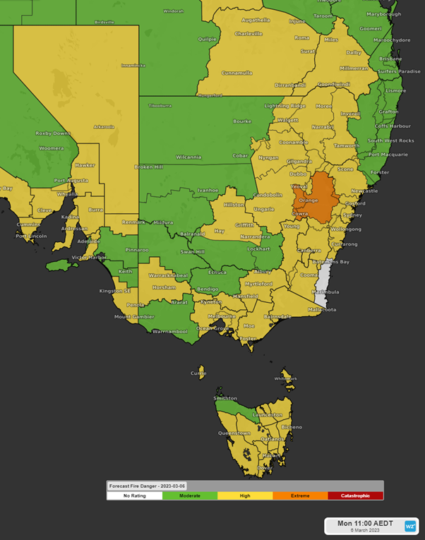
Forecast fire danger for Monday 6th March 2023
Currently no Total Fire Bans have been declared but monitor updates from your Local Fire Authority as this may change over the upcoming days.
On Monday temperatures are expected to reach into the high 30s across most of eastern NSW and southern QLD, the high 20s across eastern VIC, and mid 20s in southeast TAS.
Relative humidity will be low during the day, with much of the southeast expecting a low relative humidity of 15-30%, and around 40% in southeast TAS.
Winds will tend west to northwesterly across QLD, western and central NSW, VIC, TAS, and southern areas of SA. More southwesterly winds will be likely over northeast SA and western NSW. Winds are expected to be 20-30km/h across these areas. It will be an increased chance of wind gusts of 40-50 km/h contributing to the high ratings. Wind gusts could possibly exceed 60km/h over the NSW Central Ranges, contributing to the Extreme rating.
High fire dangers are expected to continue into Tuesday and perhaps Wednesday in the north until a cooler southerly wind moves across the region mid-week.