
Fina to pass near Darwin as severe tropical cyclone on Saturday night
Severe Tropical Cyclone Fina will pass near Darwin on Saturday night into Sunday morning, lashing the city and surrounding areas of the northwest Top End with powerful winds, heavy rain and flooding.
Fina barrelled over the Cobourg Peninsula on Friday night as a category two system, before strengthening into a category three severe tropical cyclone over the warm Van Diemen Gulf on Saturday morning. This is the first severe tropical cyclone to form in the Australian region during November for 20 years.
Video: Composite radar and satellite images showing Severe Tropical Cyclone Fina crossing the Van Diemen Gulf on Saturday. Source: Weatherzone.
By 3:30pm ACST on Saturday, Severe Tropical Cyclone Fina was sitting near the south coast of Melville Island, roughly 60 km north of Darwin, with wind gusts reaching around 205 km/h near its core.
A few weather stations in the northwest Top End registered wind gusts above 100 km/h on Saturday, including:
- 104 km/h at Gunn Point shortly before 2:30pm
- 104 km/h at McCluer Island just before 2pm
- 102 km/h at Point Stuart at 8:22am
Fina has already dumped more than 200 mm of rain over parts of the northern Top End in the last couple of days. Murganella Airstrip picked up 213 mm in the 24 hours to 9am ACST on Saturday, while Point Stuart saw 208 mm in the 27 hours ending at 3pm on Saturday. Impressively, Gunn Point received more than 110 mm in four hours on Saturday afternoon.
While Darwin has so far escaped the worst weather from Fina, conditions are expected to rapidly deteriorate as the tropical cyclone gets closer to the city on Saturday afternoon and evening, possibly persisting into Sunday morning.
Darwin and surrounding areas could see wind gusts reaching about 120 to 155 km/h on Saturday night. Wind will initially build from the south and southeast, before turning more easterly and then northeasterly as the eye of Fina passes Darwin. These changing wind directions can be dangerous because they expose infrastructure and vegetation to powerful winds from a range of angles.
Rainfall rates in the Darwin region could reach 100 to 300mm in 24 hours by Sunday morning, with isolated falls possibly reaching around 500 mm over parts of the northwest Top End.
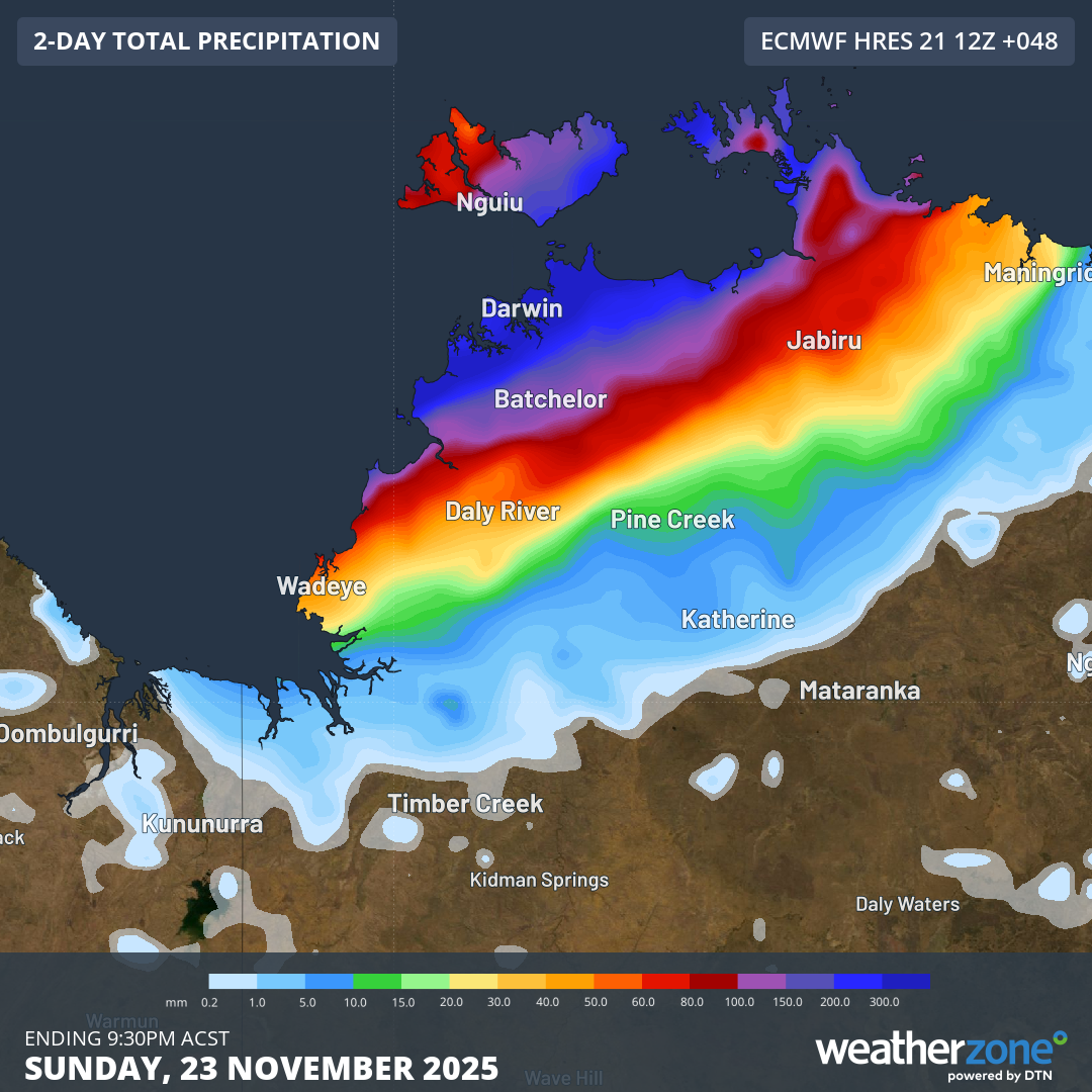
Image: Forecast accumulated rain during the 48 hours ending at 9:30pm ACST on Sunday, according to the ECMWF-HRES model.
After passing by Darwin, Fina is expected to move over the southern Timor Sea on Sunday into Monday while maintaining severe tropical cyclone intensity, possibly strengthening into a category four system. At this stage, Fina should weaken from Monday into Tuesday as it approaches WA’s north Kimberley coast.