
Extreme heat spreading through Western and Central US this week
After a massive winter storm brought a burst of arctic air through the United States over the last few days, a surge of higher temperatures is spreading through the West and Central U.S. this week.
A massive winter storm moved through the country over the weekend and Monday, producing an incredibly heavy amount of snow from southeast Minnesota into the Upper Peninsula of Michigan, where over 20 inches have fallen.
That has been followed by a quick burst of arctic air that brought temperatures down below freezing all the way to the Gulf, and below zero in the Upper Midwest.
But just as quickly as that burst of cold has moved in, it is moving out.
Temperatures in the Southwest are increasing rapidly, and records are going to be broken for the next several days. That warmth will also spread into the Plains, where snow will melt and soils will dry out, leading to more issues for wildfires and falling crop conditions for winter wheat.
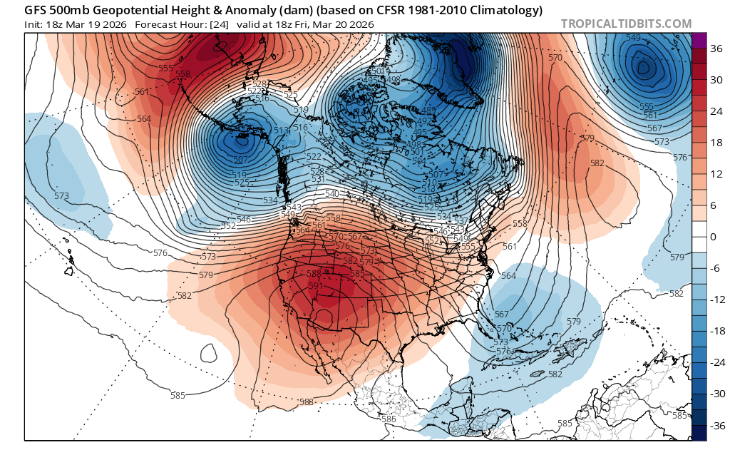
Image: 500 hPa geopotential height anomaly on Friday, March 20, 2026. An upper-level heat dome (in red) is the source of extreme warmth for the rest of this week in the West and Plains. Source: TropicalTidbits.com
For some areas, the warmth will be extreme. Temperatures in the Southwest and Southern Plains are going to be some 20 to 30 degrees above normal later this week, breaking some records, especially in the Desert Southwest.
Phoenix appears to be the area most likely to see consistent heat. Only once has the temperature hit over 100 degrees there in March, but is forecast to do so for five-straight days. Though the temperature may slip below 100 degrees next week, the forecast is still for a record-high 98 on Monday, Mar. 23, and record-high temperatures will be possible from Wednesday, Mar. 18 through Tuesday, Mar. 31, as the heat never really leaves.
For some areas, daily records will be broken by almost ten degrees, a show of just how hot this air mass will become for this time of year. Temperature reports back in the early 1900s were the source of the record highs in the Southern Plains, which may be suspect, but could still be broken on a few accounts.