
El Niño, Walker Circulation and the PDO: why this event is different
El Niño continues to strengthen across the tropical Pacific on its way to becoming a ‘Super El Niño’ this fall. But how will this event disrupt global weather patterns over the next few seasons? Here are the main ways very strong El Niño events affect global atmospheric circulation.
Atmospheric disruption and trade winds
Latest sea surface temperatures in the ‘Nino3.4 region’ of the central equatorial Pacific have recently risen 2 degrees Celsius above average, and are likely to exceed an anomaly of 3 degrees as waters continue to warm. There are even higher temperature anomalies further east, off the coasts of Peru and Ecuador.
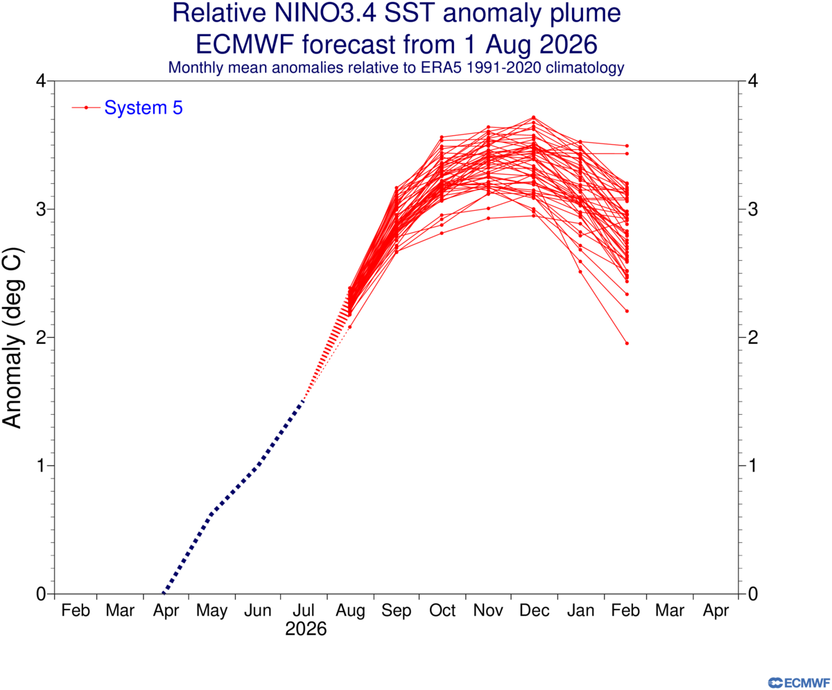
Image: Relative Niño 3.4 outlook according to the ECMWF model. Source: ECMWF.
Even during a more modest El Niño, east-west atmospheric circulations over the tropical Pacific region tend to shift and can even reverse entirely. The primary impact is on the ‘Walker cell’, which is a large-scale circulation over the equatorial Pacific, driven by pressure and temperature differences across the oceanic basin.
When conditions in the tropical Pacific are neutral, in neither an El Niño nor La Niña state, high pressure areas are situated over the eastern Pacific while low pressure develops in the western Pacific. Air travels from high pressure to low pressure, which causes easterly trade winds to develop at the surface.
These easterly trade winds push warmer water westwards, allowing cooler upwelling in the eastern equatorial Pacific. Air in contact with the warmer western Pacific water also warms and rises through convection, producing rainfall. Drier air then travels back eastwards at higher altitudes and sinks, enhancing high pressure and resulting in less precipitation in the eastern Pacific. This is the Walker cell, and it also affects circulations across the Atlantic and Indian Oceans.
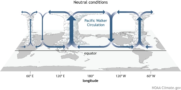
Image: Typical Walker circulation during neutral ENSO (neither La Niña nor El Niño). Source: NOAA.
La Niña, El Niño and shifting circulations
During a La Niña episode, trade winds are stronger than usual. The eastern tropical Pacific sees more upwelling of cooler water, and cool surface water spreads farther west. This in turn shoves warmer water more westward than during the neutral phase, so convection, rainfall and storms increase across northern Australia, Indonesia and other parts of southeast Asia.
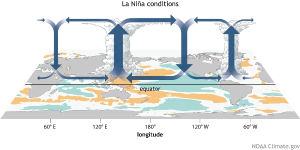
Image: Typical changes to the Walker circulation during La Niña. Source: NOAA.
El Niño, on the other hand, is associated with weaker trade winds, which may at times even reverse, allowing warmer water to slosh back eastwards across the Pacific. This slows or stops the upwelling of cool water near the South American coast, shifting the atmospheric circulation of the Walker cell significantly eastwards, or weakening it. Deep convection increases across the central/eastern tropical Pacific, with rising air traveling back westwards in the upper troposphere before subsiding over the western Pacific or Indonesia, where it suppresses rainfall.
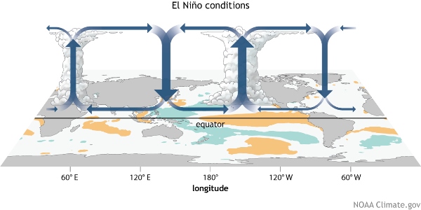
Image: Typical changes to the Walker circulation during El Niño. Source: NOAA.
Rossby waves
The Walker circulation does not work in isolation. Instead, it is a major cog in the machinery of much wider atmospheric circulations around the world. Its eastward shift during El Niño realigns where large-scale planetary waves, known as Rossby waves, push into the mid and high latitudes, and these in turn reshape the course of subtropical and polar jet streams.
.png)
Image: A wavy jet stream typically associated with a Rossby wave. Source: NOAA.
El Niño events in fall and winter often strengthen the subtropical jet across the southern US and bring an increase in wintertime precipitation. The polar jet tends to shift farther north, and, despite chances of occasional colder outbreaks, much of Canada and the northern US have milder-than-normal winters. This is most probable during strong east-based El Niño phases, which is what is expected this winter.
However, we will potentially be entering uncharted territory with the anticipated strength of El Niño as it peaks towards December. What is particularly notable is that it is, for now at least, coinciding with a negative phase of the Pacific Decadal Oscillation (PDO) in the North Pacific.
The Aleutian Low and the PDO
The PDO is the primary pattern of sea surface temperature (SST) anomalies in the North Pacific. It is currently in a negative phase, and has mostly been so since about 2017. A negative PDO features warmer than normal water in the central northern Pacific with cooler seas towards the western coasts of North America.
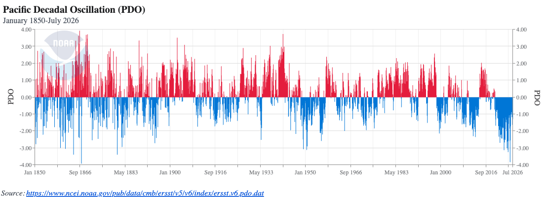
Image: Pacific Decadal Oscillation (PDO) between 1850 and 2026. Source: NOAA.
The ongoing El Niño development could cause a shift in this pattern, in an interesting interaction between decadal (PDO) and inter-annual (La Niña/El Niño) variability. Rossby waves that propagate into the North Pacific can deepen low pressure near the Aleutian Islands and strengthen the Pacific jet stream.
A deeper Aleutian low causes more of a southerly wind to develop near western coasts, reducing cold water upwelling and allowing sea surfaces to warm. Meanwhile, this more potent low pressure can strengthen winds across the central North Pacific, causing more mixing between surface and deeper water, resulting in cooling. So, the PDO’s sea surface temperature anomaly pattern can ease or reverse.
Will the PDO turn positive?
The central North Pacific is particularly warm at the moment, so it will require quite a turnaround to move towards a positive PDO phase. And a positive index might not last, with underlying negative PDO base state possibly returning in 2027 as El Niño eventually weakens.
However, strong El Niño winters like 1982-83 and 1997-98 did help to produce very deep Aleutian lows and stronger winds, with the PDO into a positive or strongly positive state.
A strong east-based El Niño and simultaneous positive PDO can reinforce the expected patterns across North America. But the combination of a negative PDO and increasingly strong El Niño has little precedent, making analogue methods of predicting the coming fall and winter rather more fraught.
Indeed, none of the recorded Super El Niño events maintained a negative PDO, and only the 1972-73 winter came close, with a mostly neutral or slightly negative PDO initially, becoming positive later in the season.
Meteorologists will be closely watching how El Niño and the PDO interact over the next few seasons. You will find updates on these climate drivers on the Weatherzone news feed in the months ahead.