
El Niño shaping Australia’s winter-spring 2026 weather outlook – in maps
Australia could be in for an unusually dry and warm winter and spring this year as a developing El Niño causes high pressure systems to dominate Australia’s weather patterns in the coming months.
Will El Niño develop in 2026?
There are clear signs that an El Niño pattern is becoming established in the tropical Pacific Ocean, with several key oceanic and atmospheric indices tipping over El Niño thresholds in recent weeks.
While the Pacific Ocean region is still only in early stages of this ocean-atmosphere coupling, there is strong consensus between long-range computer models that El Niño will strengthen in the coming months and persist through the Southern Hemisphere’s winter and spring. Current forecasts suggest that this El Niño could be a strong event.
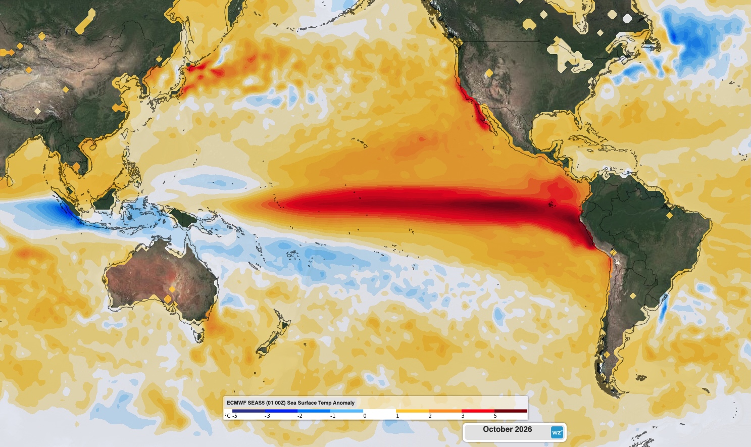
Image: Forecast sea surface temperature anomaly in October 2026, showing a distinctive El Niño pattern in the Pacific Ocean. Source: Weatherzone.
In addition to El Niño, there are also signs that a positive Indian Ocean Dipole (IOD) could develop in winter or spring. While there is a large amount of uncertainty regarding the IOD in the coming months, it will most likely be neutral or positive during winter-spring 2026.
How will El Niño affect Australia this year?
Every El Niño event is different, and they do not always have the same impact on Australian weather. However, there are some types of weather that become more likely in Australia when El Niño is underway. El Niño promotes:
- Above average daytime temperatures across most of Australia, particularly in the southern half of the country
- Below-normal minimum temperature across most of Australia in winter and early spring.
- Below-average rainfall, especially in the east and north
- Higher likelihood of drought
- Increased bushfire risk
- Delayed monsoon onset in northern Australia
- Decreased alpine snow depths and a shorter snow season
If a positive IOD does develop, this will further enhance the likelihood of abnormally dry and warm weather in Australia during winter and spring.
This year’s developing El Niño and possible positive IOD are already beginning to influence the outlooks for winter and spring.
Rainfall
Long-range forecast models are predicting below average rain for most of Australia during the next six months. This does not mean it won’t rain at all, but most of the country is expected to see less rain than usual when averaged out across the whole month or season.
The six maps below show the likelihood of having a wetter than average month, with brown shaded areas expected to be drier than normal and blue shaded areas expected to be wetter than normal.
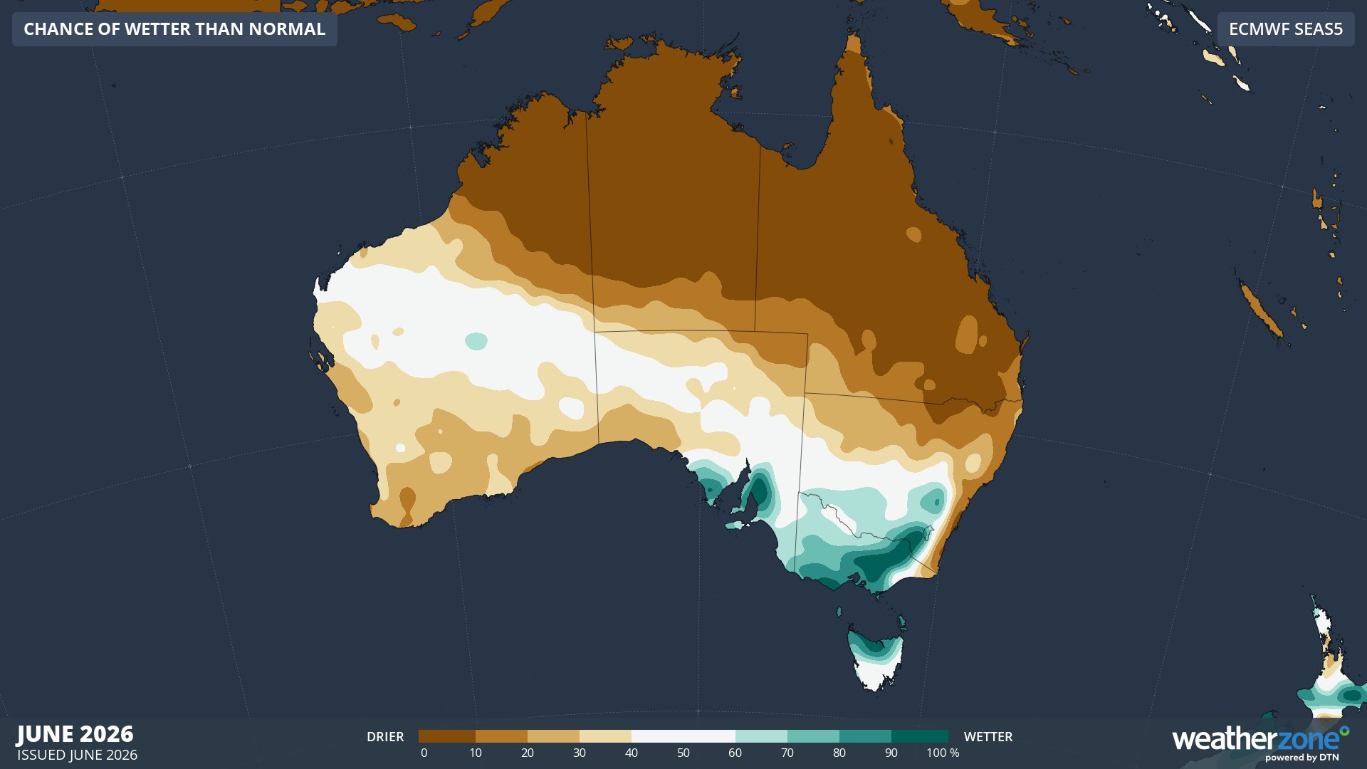
Image: Chance of exceeding median rainfall in June 2026. Source: Weatherzone / ECMWF SEAS5
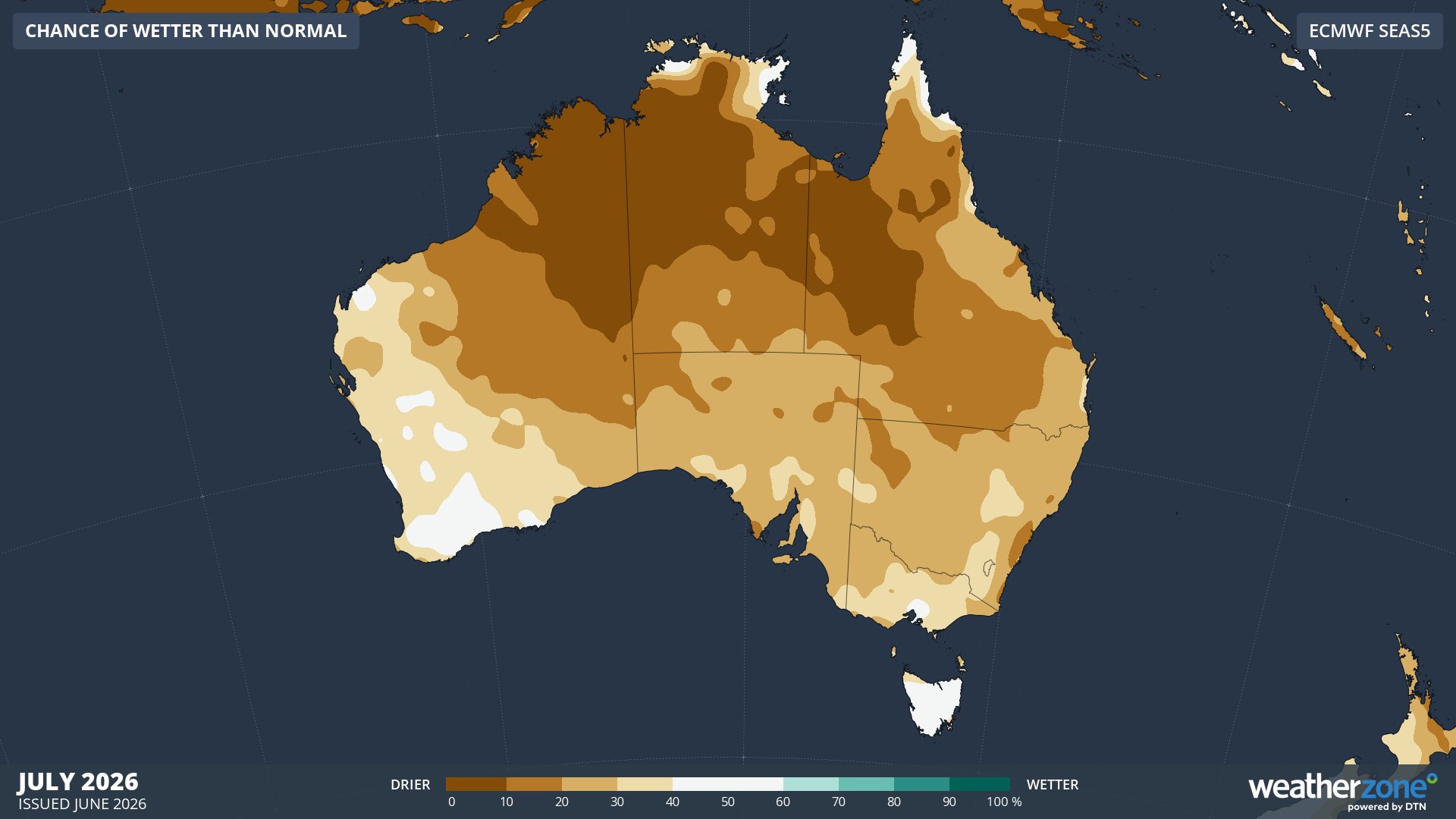
Image: Chance of exceeding median rainfall in July 2026. Source: Weatherzone / ECMWF SEAS5
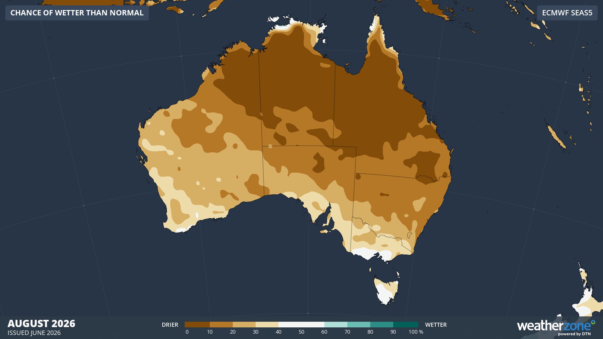
Image: Chance of exceeding median rainfall in August 2026. Source: Weatherzone / ECMWF SEAS5
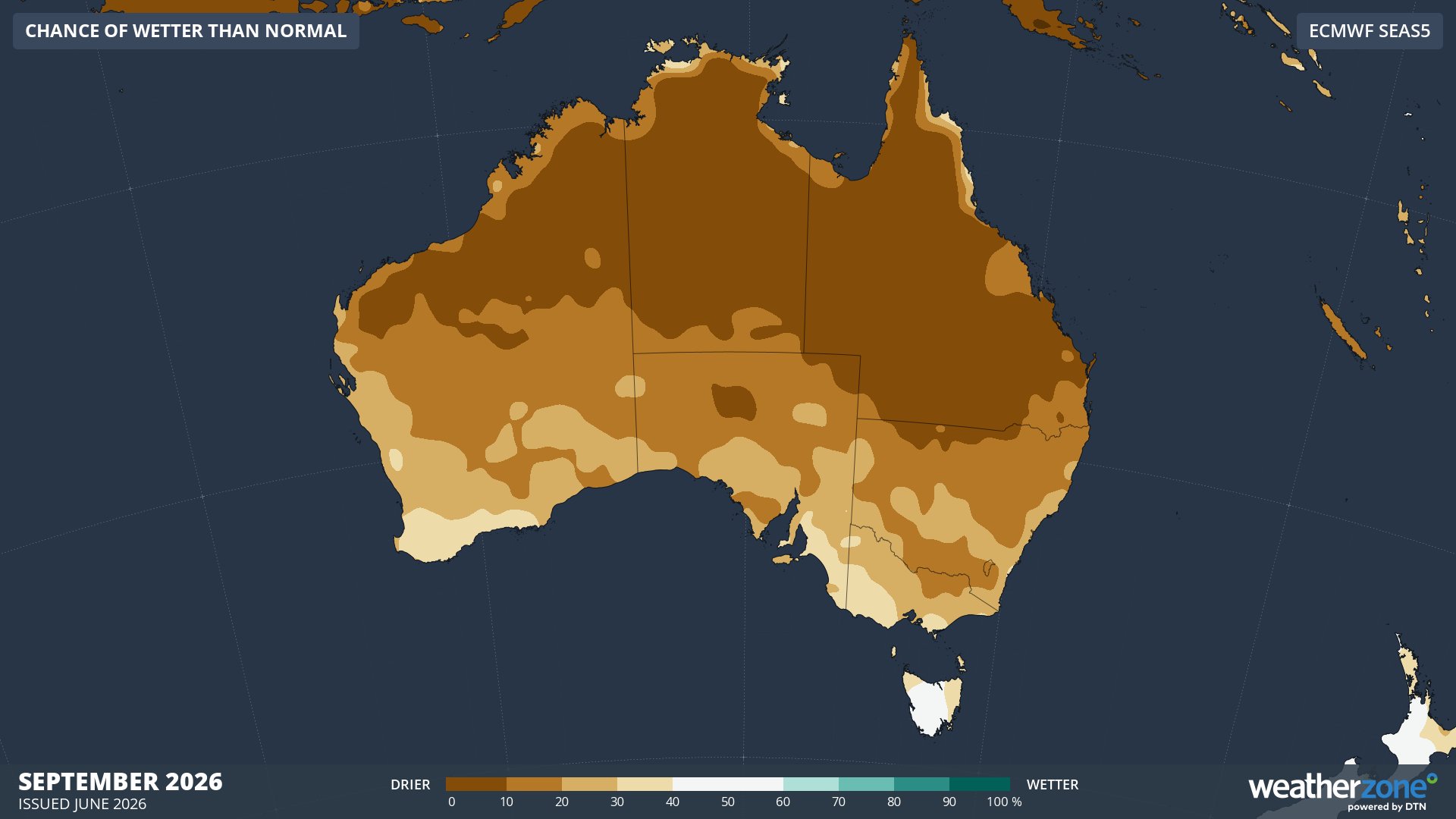
Image: Chance of exceeding median rainfall in September 2026. Source: Weatherzone / ECMWF SEAS5
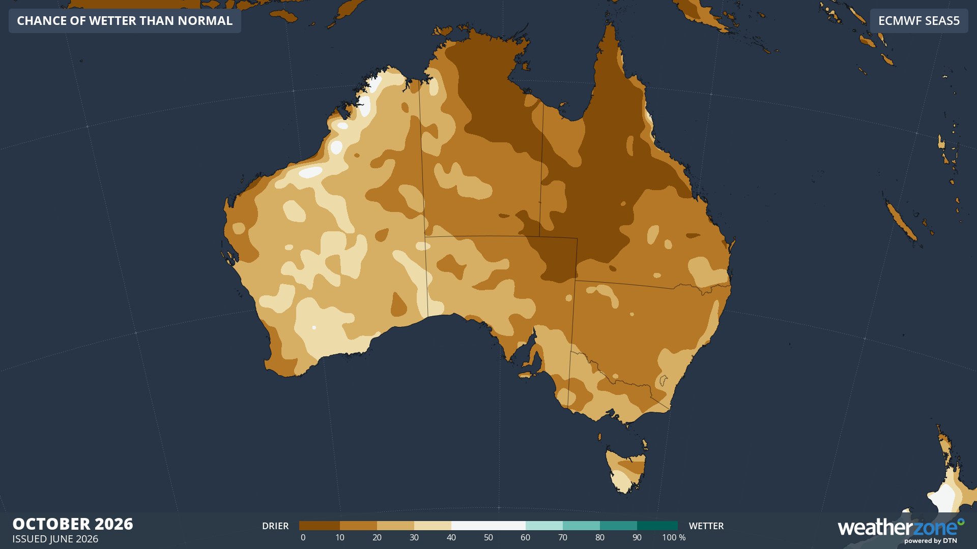
Image: Chance of exceeding median rainfall in October 2026. Source: Weatherzone / ECMWF SEAS5
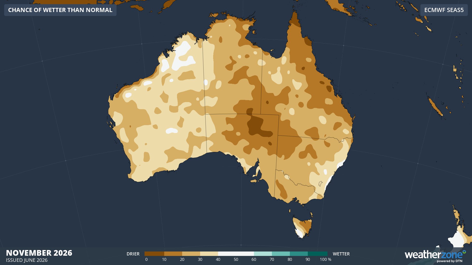
Image: Chance of exceeding median rainfall in November 2026. Source: Weatherzone / ECMWF SEAS5
The Bureau of Meteorology’s winter rainfall outlook also shows an increased likelihood of below-average rain across parts of southern and eastern Austrlia between July and September, although near to above average falls are predicted in some areas of the country's north and west.
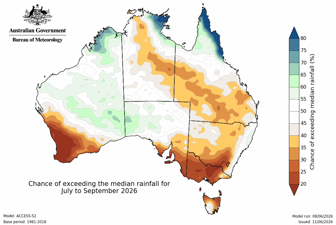
Image: Chance of exceeding median rainfall between July and September 2026. Source: Bureau of Meteorology.
Temperature
El Niño promotes warmer-than-average daytime temperatures over the southern half of Australia due to less cloud cover and higher-than-normal mean sea level pressure. This relationship between El Niño and warmer daytime temperatures is strongest during the second half of the year, during spring and summer.
In contrast, overnight minimum temperatures can be cooler-than-average over parts of Australia during an El Niño winter. This is due to less cloud cover allowing more radiative cooling at night.
Forecast models suggest that daytime temperatures will be variable across Australia during winter, with some areas cooler than average and some areas warmer than average. However, heading into spring, daytime temperatures are expected to trend warmer than average in the southern half of the country and cooler than normal in the country’s north. Maximum temperatures are predicted to be warmer than normal for most of the country by late spring.
Some areas of Australia could experience below-average minimum temperatures this winter, although overnight minimums should trend above normal for most of the country in spring.
The maps below show the likelihood of having a warmer than average month based on maximum temperatures, with red shaded areas expected to be warmer than normal and blue shaded areas expected to be cooler than normal.
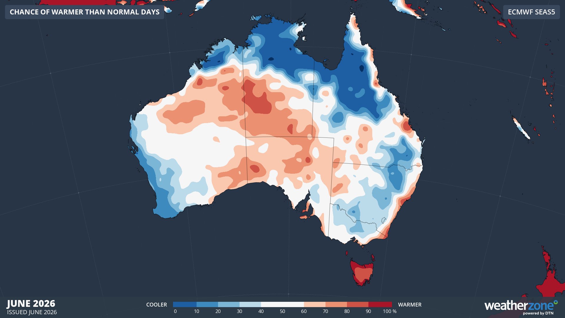
Image: Chance of exceeding median maximum temperature in June 2026. Source: Weatherzone / ECMWF SEAS5
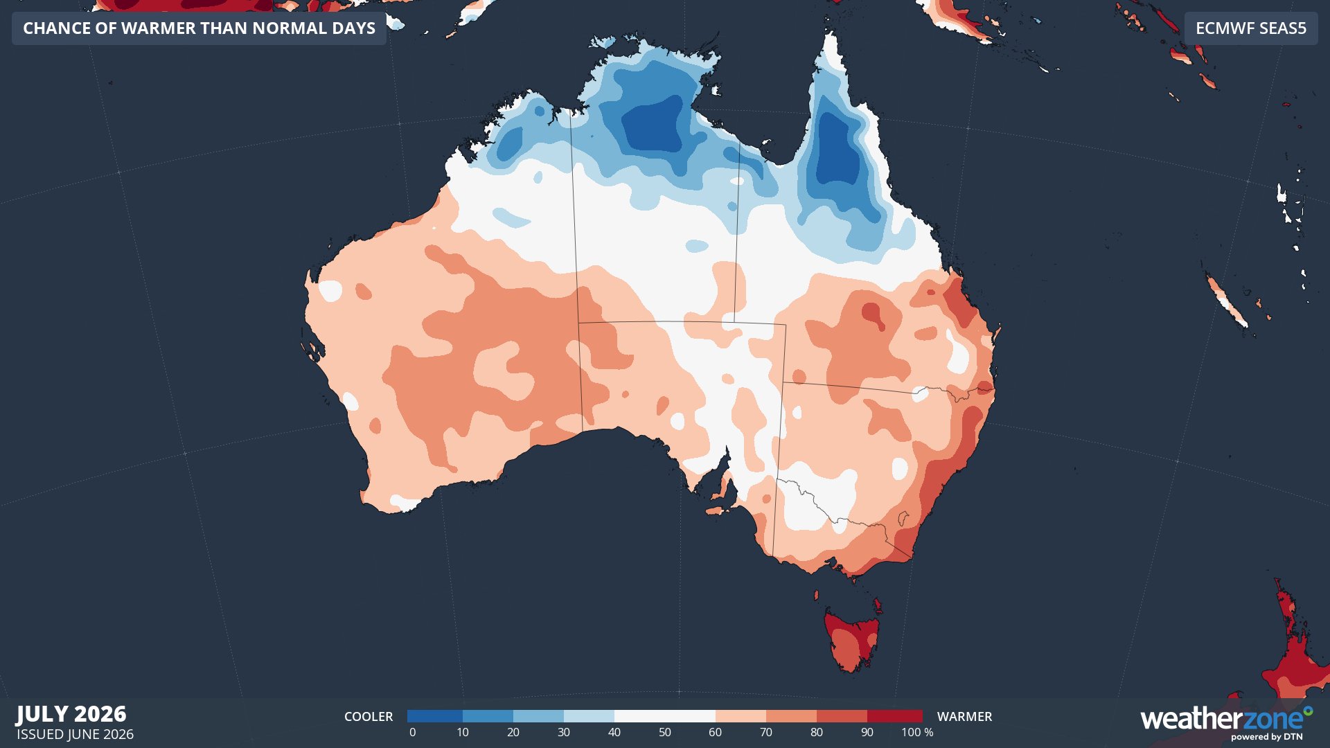
Image: Chance of exceeding median maximum temperature in July 2026. Source: Weatherzone / ECMWF SEAS5
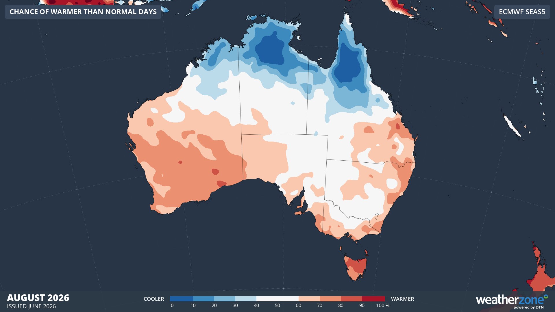
Image: Chance of exceeding median maximum temperature in August 2026. Source: Weatherzone / ECMWF SEAS5
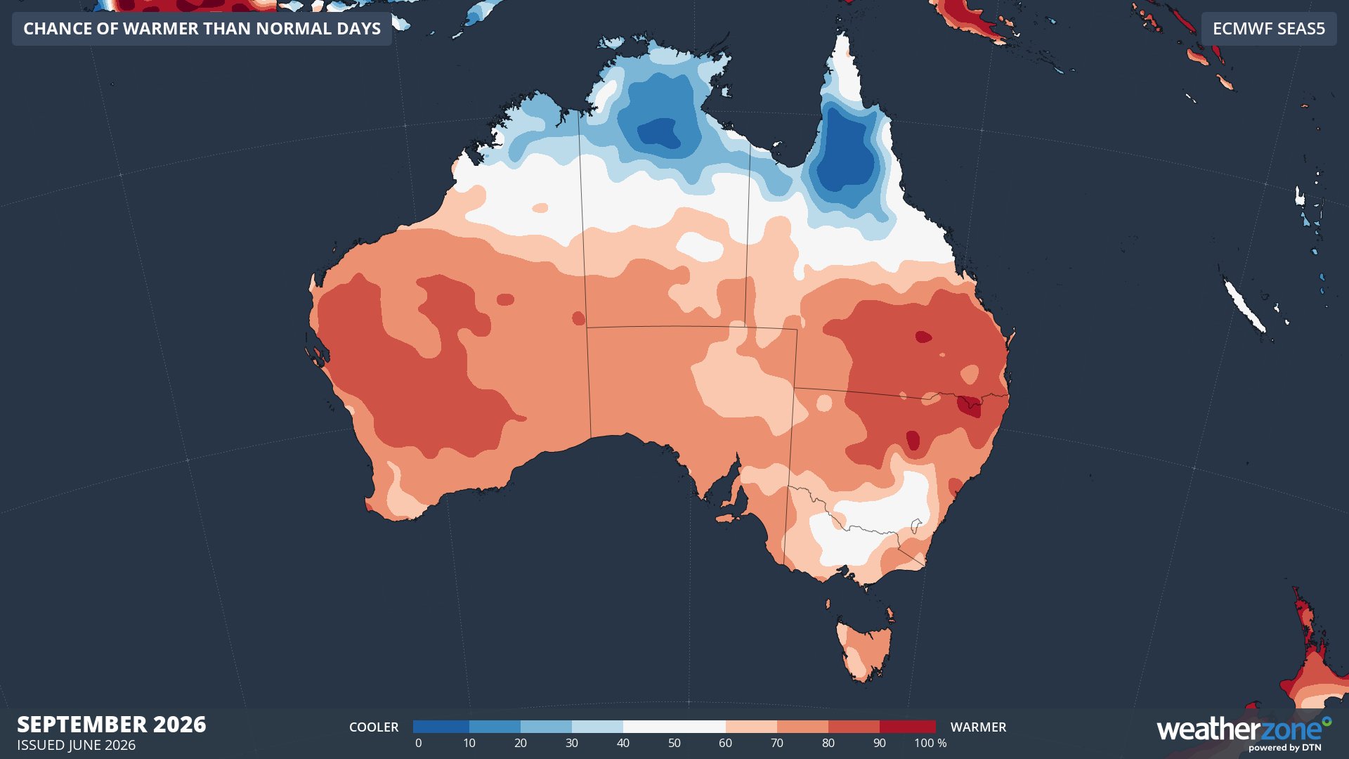
Image: Chance of exceeding median maximum temperature in September 2026. Source: Weatherzone / ECMWF SEAS5
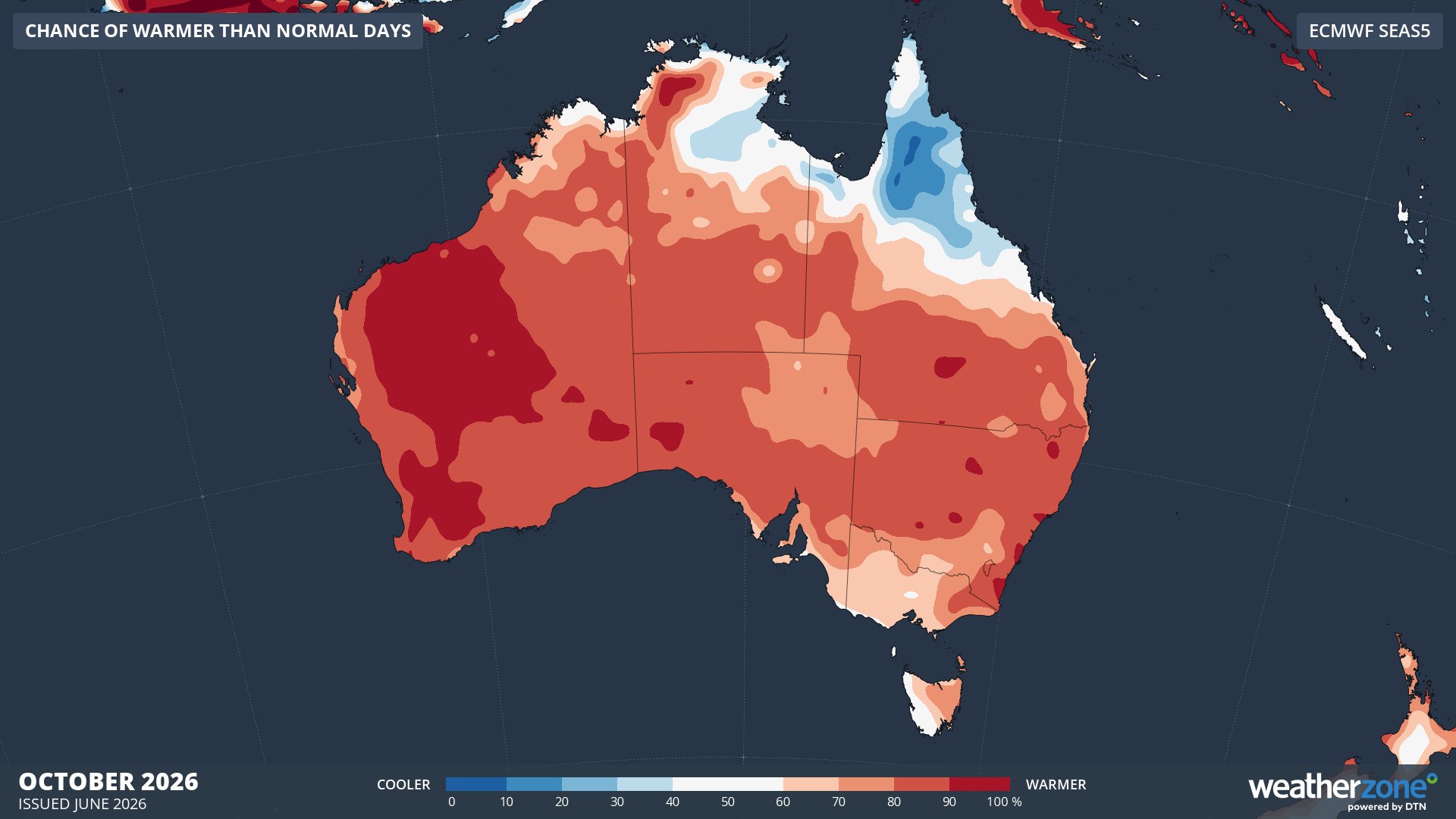
Image: Chance of exceeding median maximum temperature in October 2026. Source: Weatherzone / ECMWF SEAS5
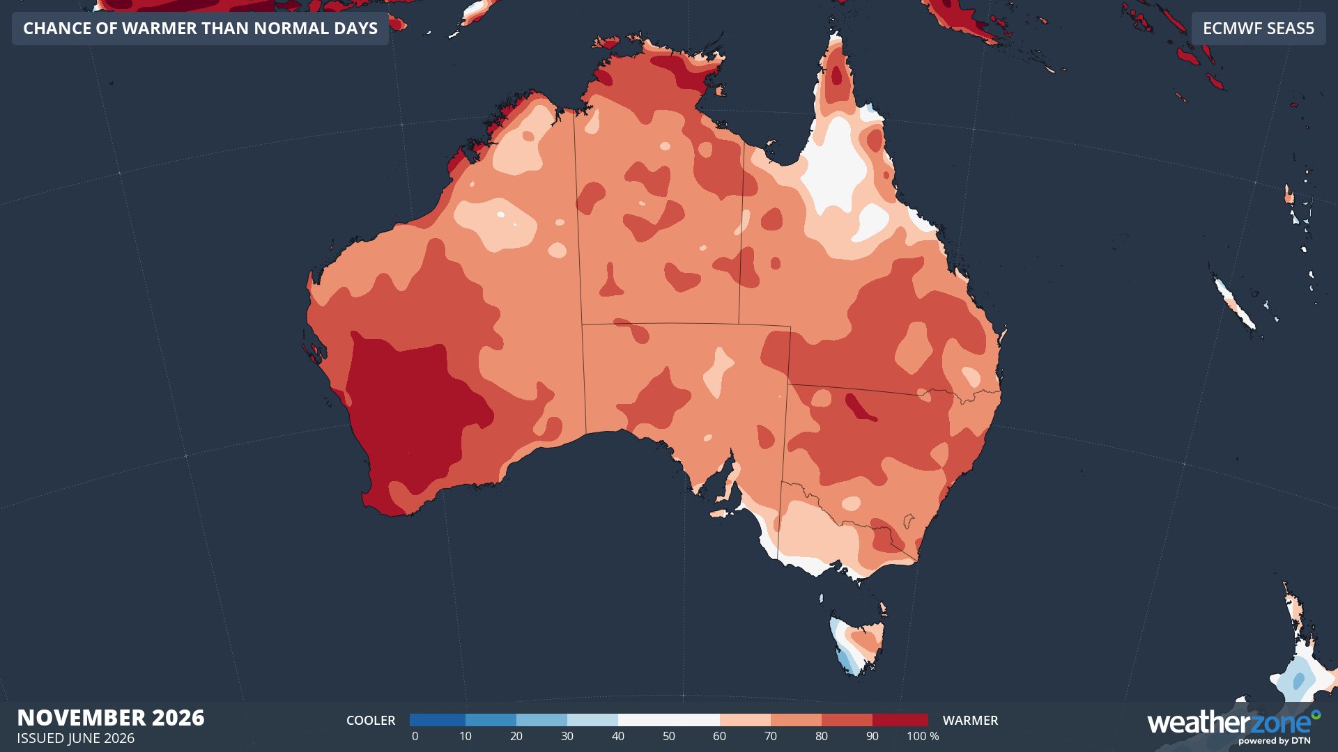
Image: Chance of exceeding median maximum temperature in November 2026. Source: Weatherzone / ECMWF SEAS5
The Bureau of Meteorology’s maximum temperature outlook for winter also shows an increased chance of above average daytime temperatures across most of the country, except for some areas in northern Australia.
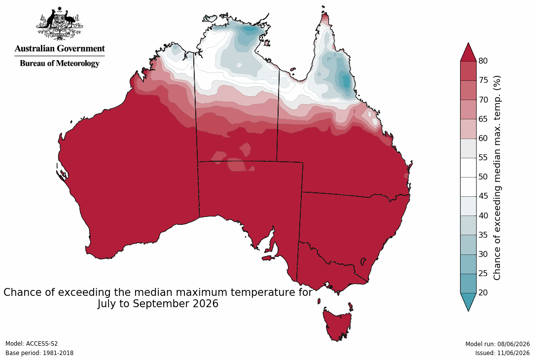
Image: Chance of exceeding median maximum temperature between July and September 2026. Source: Bureau of Meteorology.
Atmospheric pressure
One of the main ways El Niño influences weather patterns in Australia is by promoting higher mean sea level pressure and reducing the prominence of low pressure systems and cold fronts. This happens because El Niño weakens trade winds in the tropical Pacific region, resulting in less warm and moisture-laden air flowing towards Australia from the northeast. These weaker trade winds cause less rising air in the Australian region, with descending air becoming more prominent, resulting in higher mean sea level pressure.
As a general rule of thumb, high pressure is associated with dry and settled weather, while low pressure is associated with clouds, rain and snow. High pressure near southern Australia can also block cold fronts, reducing the frequency and intensity of cold outbreaks during winter.
Abnormally high sea level pressure is likely to influence Australia’s weather in winter and spring this year. This pattern suggests that cold outbreaks may occur less frequently and be less intense than usual in the coming months. This suppression of strong cold fronts may hinder snowfall in the Australian Alps. However, there will still be outbreaks of cold weather and snow.
The following maps show the forecast sea level pressure anomalies between June and November 2026. The orange-brown shaded areas are expected to see higher-than-normal mean sea level pressure, while blue shaded areas are expected to have below-average mean sea level pressure.
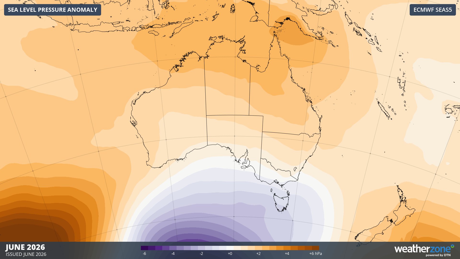
Image: Forecast mean sea level pressure anomaly in June 2026. Source: Weatherzone / ECMWF SEAS5
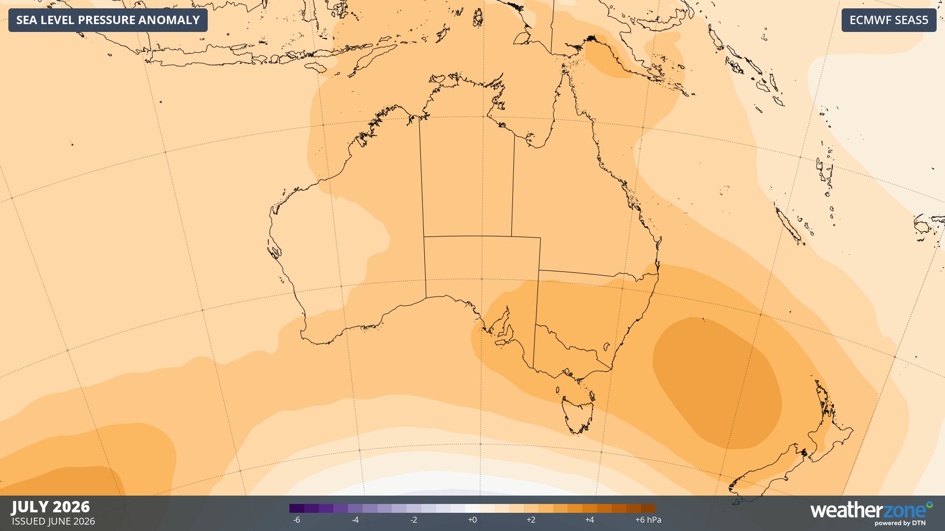
Image: Forecast mean sea level pressure anomaly in July 2026. Source: Weatherzone / ECMWF SEAS5
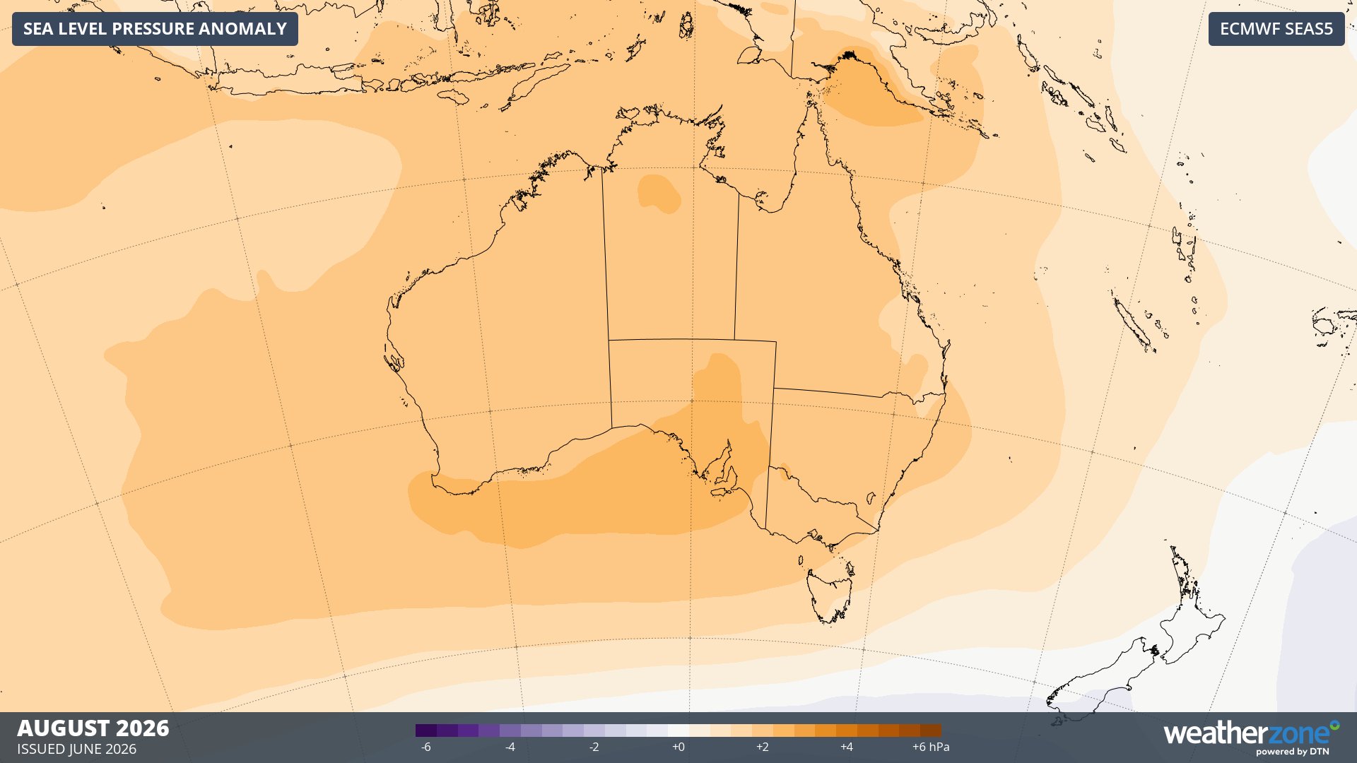
Image: Forecast mean sea level pressure anomaly in August 2026. Source: Weatherzone / ECMWF SEAS5
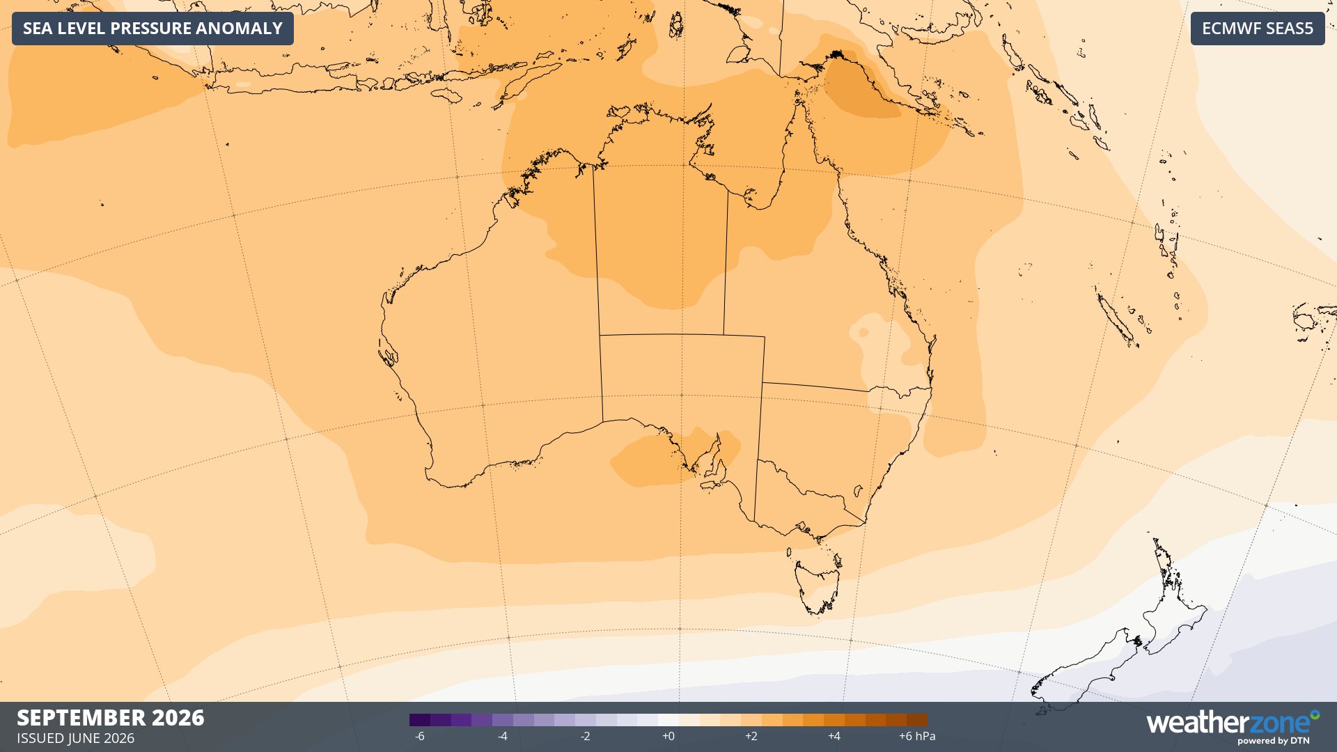
Image: Forecast mean sea level pressure anomaly in September 2026. Source: Weatherzone / ECMWF SEAS5
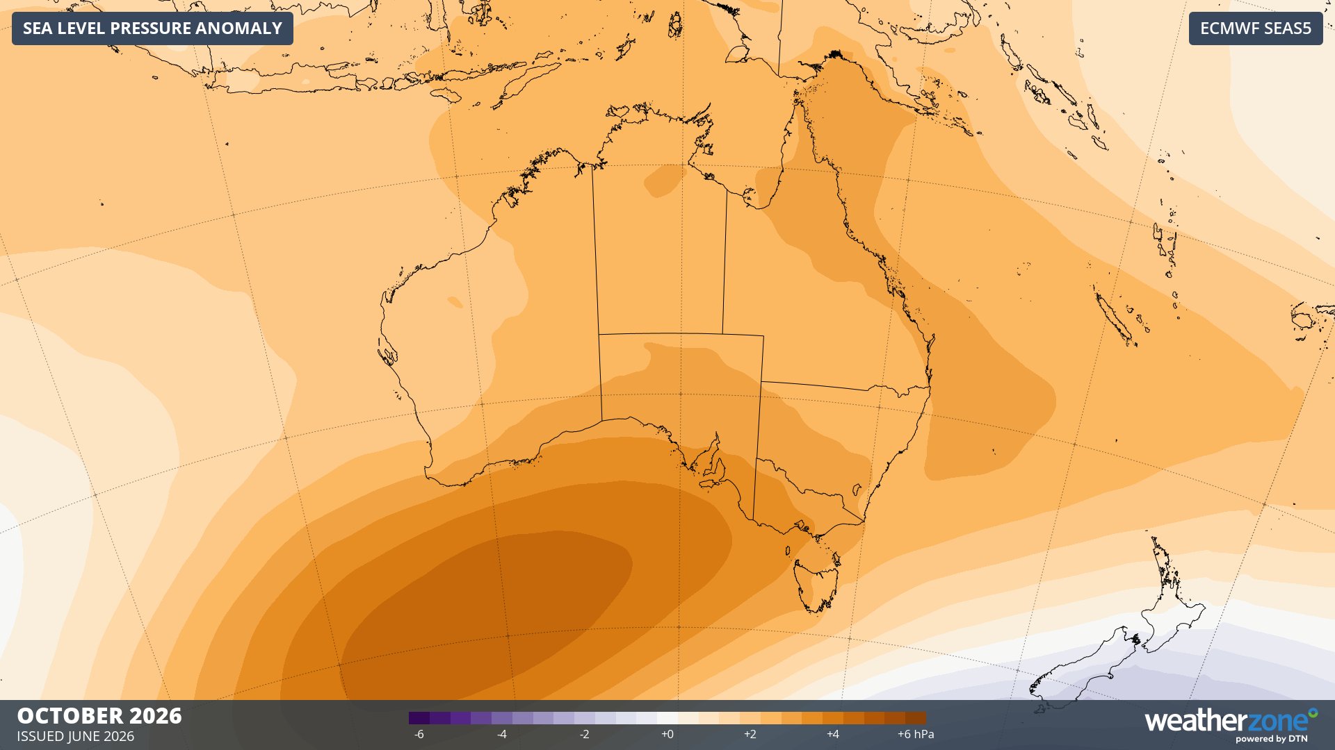
Image: Forecast mean sea level pressure anomaly in October 2026. Source: Weatherzone / ECMWF SEAS5
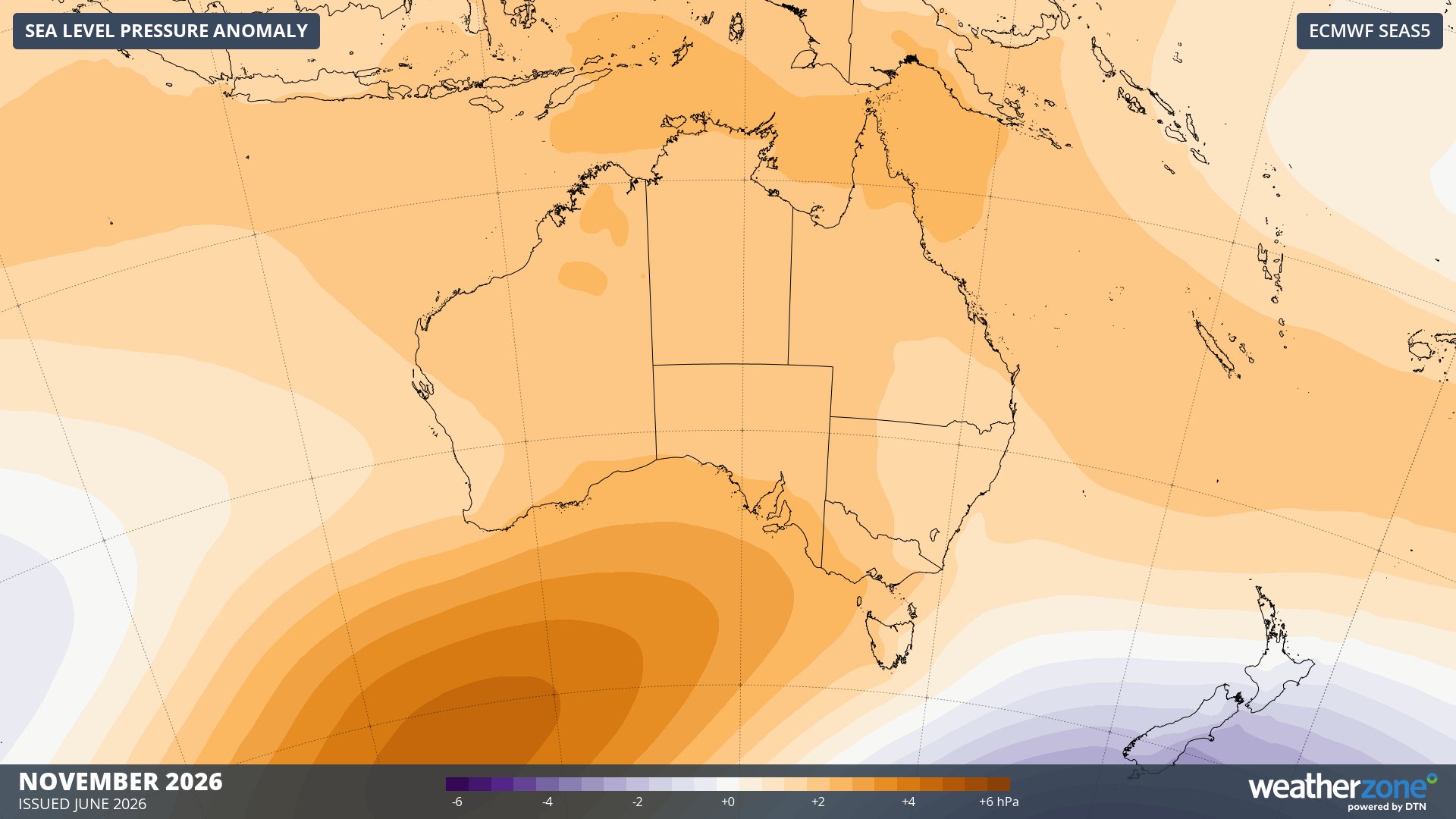
Image: Forecast mean sea level pressure anomaly in November 2026. Source: Weatherzone / ECMWF SEAS5
Australia’s seasonal outlooks may change as El Niño and other climatic influences continue to evolve over the coming months. You can check out the latest rainfall and maximum and minimum temperature outlooks on the Weatherzone website. These outlooks usually update in the first week of each month.