
El Niño is here and it could challenge records in 2026
The Bureau of Meteorology has declared that El Niño has arrived and it is likely to last until at least the end of the year. Forecast models also suggest this could be one of the strongest El Niño events on record.
What is El Niño?
El Niño is one of three phases of the El Niño-Southern Oscillation (ENSO) – a global ocean and atmosphere phenomenon originating in the tropical Pacific. The other phases of ENSO are La Niña and neutral (neither El Niño nor La Niña).
El Niño occurs when sea surface temperatures in the tropical Pacific become warmer than average and trade winds blowing across the tropical Pacific weaken or reverse. These changes cause cloud and rainfall to become suppressed in the western Pacific and enhanced over the central and eastern Pacific. El Niño also causes changes to rainfall and temperatures patterns in other parts of the world.
El Niño usually takes months to become established and often lasts for several consecutive seasons, sometimes persisting over a couple of years. El Niño events typically start in autumn or winter, peak in spring or summer and decay early in the new year.
El Niño declared
On Tuesday, June 16, the Bureau of Meteorology declared that El Niño was underway in the tropical Pacific. This declaration followed several months of increasing temperature anomalies in the central and eastern tropical Pacific Ocean and recent atmospheric changes that are consistent with an El Niño pattern.
According to the Bureau, “Sea surface temperatures (SSTs) in the central tropical Pacific are above El Niño thresholds, and atmospheric indicators are also aligning with an El Niño state. This suggests the ocean and atmosphere are acting to reinforce the ENSO state.”
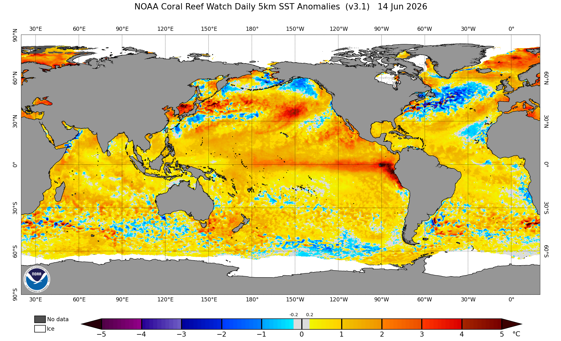
Image: Global sea surface temperature anomalies on June 14, 2026, showing a tongue of abnormally warm water in the central and eastern tropical Pacific Ocean. This is a clear sign of El Niño. Source: NOAA.
This declaration from the Bureau follows a similar announcement from the United States National Weather Service (NWS) on Thursday, June 11. Earlier in the month, the World Meteorological Organization (WMO) had also issued a statement warning the world to prepare for El Niño, noting that it could be a strong event that “will exacerbate drought and heavy rainfall and increase the risk of heatwaves both on land and in the ocean.”
This El Niño could be one for the record books
Current forecasts indicate that this El Niño will continue to strengthen during the Southern Hemisphere’s winter and spring and will likely last beyond the end of the year. This El Niño is expected to become a strong or very strong event, with the Bureau pointing out that “around half of the models indicate this event could peak at levels among the highest observed since 1950.”
One of the key metrics used to measure El Niño is the relative Niño3.4 index – a measure of sea surface temperature anomalies on the central tropical Pacific Ocean. In Australia, El Niño occurs when the relative Niño3.4 index is above +0.8°C for a prolonged period.
According to data on the Bureau of Meteorology’s website, the highest monthly Niño 3.4 value in records dating back to 1900 was +2.65°C in November 1902. The Bureau’s ACCESS-S model currently forecasts the relative Niño3.4 index to reach +3.3°C in November this year, which would obliterate the old record by more than 0.6°C.
What does this El Niño mean for Australia?
No two El Niño events are the same and stronger El Niño events do not necessarily relate to stronger impacts in Australia. However, El Niño typically makes the following weather more likely in Australia:
- Reduced rainfall during winter and spring, particularly over the eastern half of Australia.
- Above average daytime temperatures in southern and southeastern Australia from winter to summer.
- Increased winter and early-spring frost risk in southeastern Australia due to clearer skies.
- Less snow, including a lower peak snow depth and shorter snow season.
- Delayed monsoon onset in northern Australia.
- Increased risk of fires.
Current long-range forecasts for Australia point towards below average rain over large areas of southern and eastern Australia between July and September this year. Daytime temperatures are also expected to be higher than average for much of the country during this three-month period.
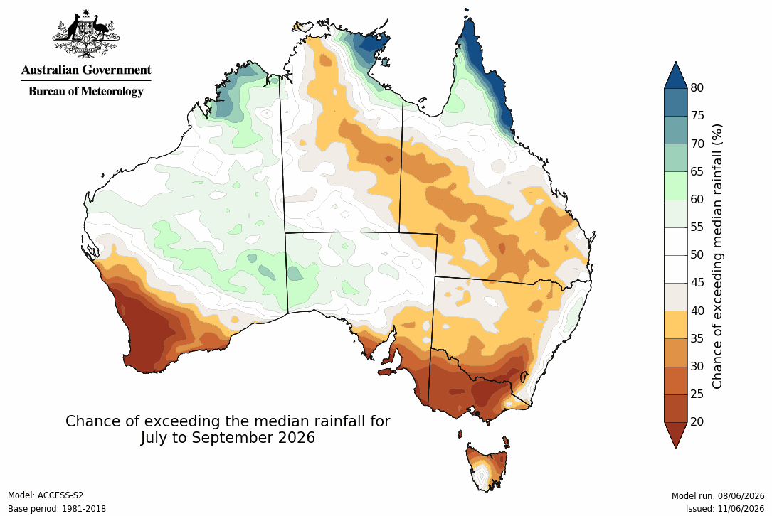
Image: Chance of exceeding median rainfall during the three-month period from July to September 2026. Source: Bureau of Meteorology.
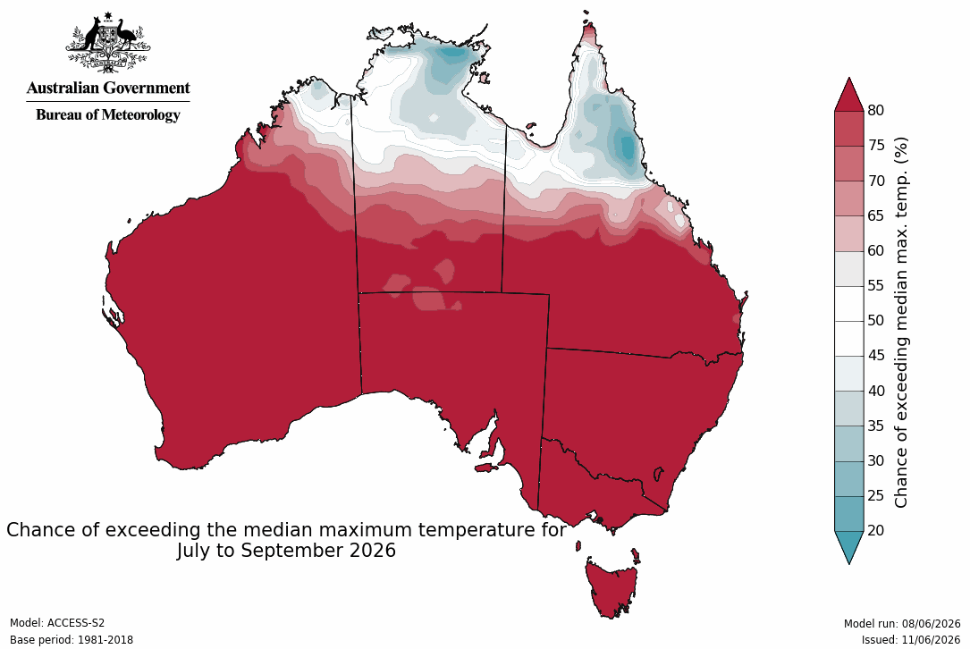
Image: Chance of exceeding median maximum temperature during the three-month period from July to September 2026. Source: Bureau of Meteorology.
It’s also important to note that El Niño will not be the only influence on Australia’s weather during the coming months and seasons. Other climate drivers, including the Indian Ocean Dipole (IOD) and Southern Annular Mode (SAM) may also enhance or counteract the influence of El Niño as we move through the second half of 2026.