
El Nino Guide: What is El Nino and how does it affect Australia?
El Niño is one of the most well-known natural climate drivers on Earth. It can influence weather around the world, promoting drought, heat and bushfires in some areas and rain and floods in others.
Understanding the causes and effects of El Niño is essential for preparing for its impacts on Australia and other parts of the world. This guide will provide an overview of El Niño and explain why it is so important to be aware of its possible consequences.
What is El Niño?
El Niño is characterised by unusually warm water in the central and eastern tropical Pacific Ocean, and cooler-than-usual water in the western tropical Pacific Ocean. This pattern of abnormal sea surface temperatures typically causes the easterly trade winds that flow across the tropical Pacific Ocean to weaken, or even reverse.
El Niño often leads to changes in global weather patterns including increased rainfall in some regions and drought in others. El Niño can have far-reaching effects on agricultural production, wildlife populations, ocean fisheries and coastal communities.
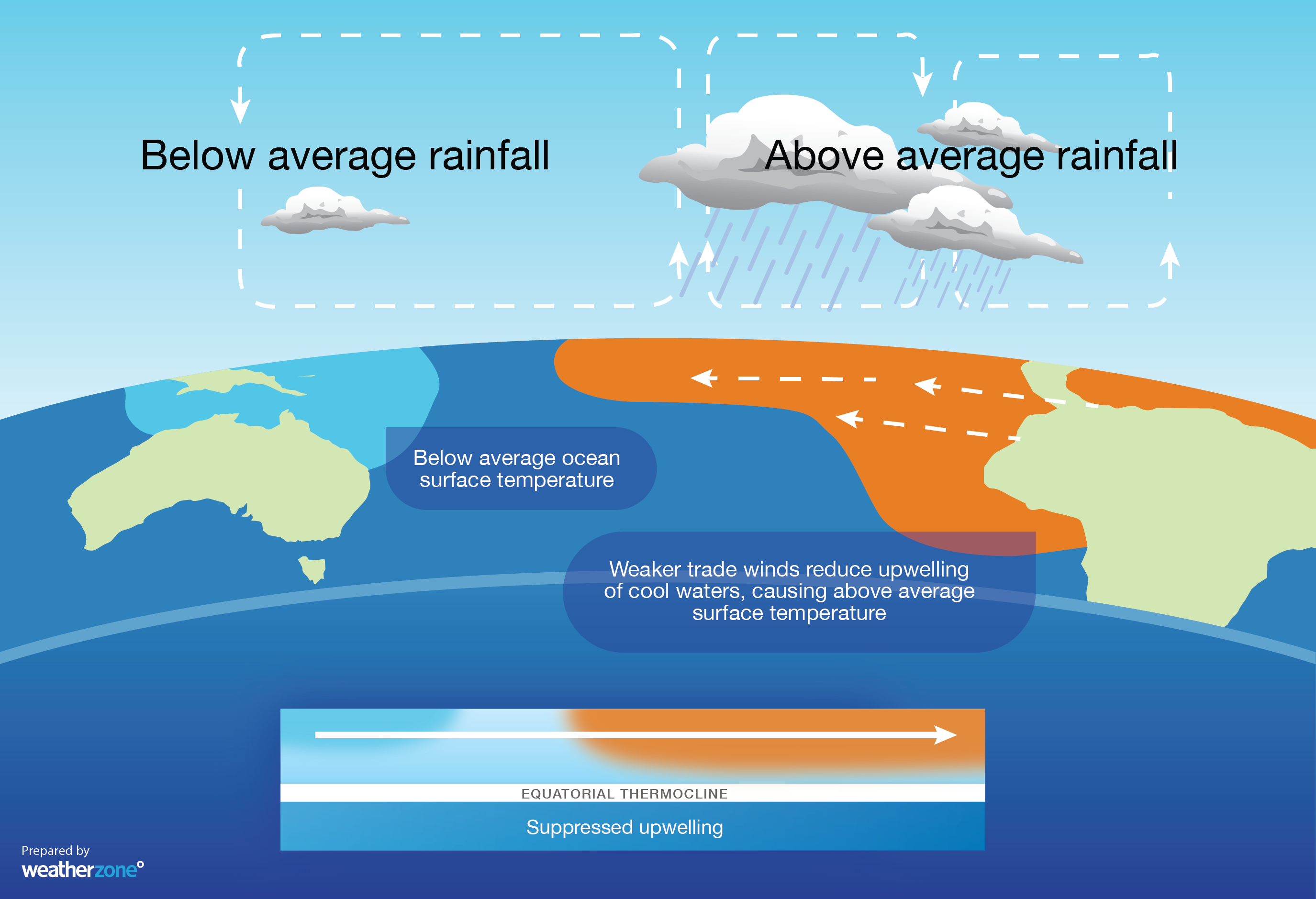
Image: Typical state of the ocean and atmopshere during El Niño.
What Causes El Niño?
El Niño is caused by a complex interplay of various factors, including atmospheric and oceanic circulations.
At its core, El Niño is the result of a temporary weakening or reversal of the trade winds over the tropical Pacific Ocean. These winds usually blow from east to west, causing colder water to well up from the depths of the ocean off the coast of South America. When these trade winds weaken, this upwelling of cold water decreases, allowing warmer water to flow back towards the eastern Pacific Ocean.
The most common cause of these weakened trade winds is the formation of severe tropical cyclones in the western Pacific. When these form in particular patterns, they send a tropical wave along the equator towards South America, weakening the trade winds as the wave passes.
How is El Niño Predicted?
Climatologists predict El Niño using various methods that require advanced technology, scientific knowledge, and continuous monitoring of various weather patterns. They use data collected from numerous sources, including weather satellites, ocean buoys, and ships. Data from these sources is fed into sophisticated computer models, which help forecasters make predictions about future climate and weather patterns.
One of the primary indicators that climatologists use to predict El Niño is the temperature of the equatorial Pacific Ocean. A rise in sea surface temperature in key regions, accompanied by a weakening of trade winds, can signify the onset of El Niño.
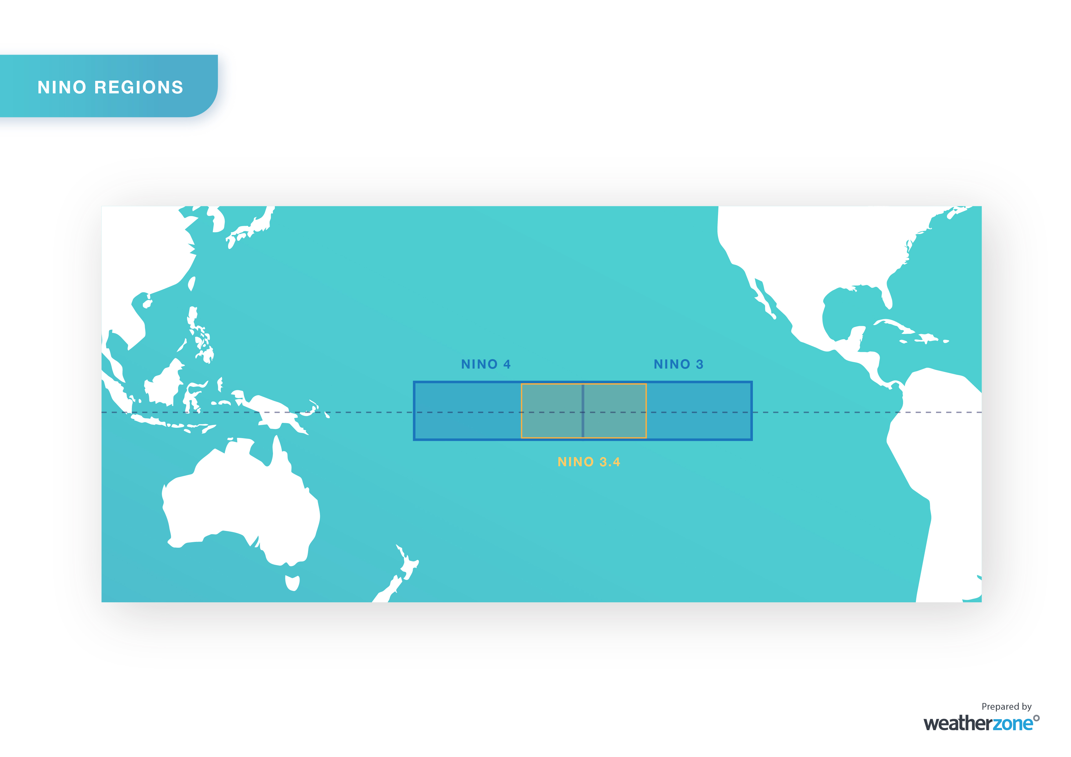
Image: Key regions of the tropical Pacific Ocean used for monitoring sea surface temperatures associated with El Niño and La Niña.
Another way climatologists predict El Niño is by tracking the atmosphere above the tropical Pacific Ocean, including air pressure, wind and cloudiness.
The Southern Oscillation Index (SOI) measures the difference in air pressure between Tahiti and Darwin, Australia. A persistently positive SOI value can indicate La Niña conditions, while a persistently negative SOI suggests that El Niño could be developing or occurring.
In addition to air pressure, meteorologists also analyse Pacific Ocean wind patterns and cloud cover near the equator, as these can also indicate the presence or absence of El Niño.
It is essential to note that despite these advanced methods, predicting El Niño accurately is still a challenging task. The exact timing, intensity, and duration of El Niño can differ significantly from one event to another, making it difficult for climatologists to provide accurate predictions. Nonetheless, continuous monitoring and improved technology have helped climatologists get better at predicting El Niño, enabling them to provide early warnings and prepare communities and industries for potentially dangerous weather events.
Impacts of El Niño in Australia
El Niño Event: Reduction in Amount of Rainfall
El Niño is often associated with decreased rainfall over large parts of Australia, particularly during winter and spring. Most of eastern Australia’s driest winter-spring periods have occurred during El Niño years.
The dry and warm weather that is associated with El Niño in Australia also increases the likelihood of drought, particularly when El Niño is part of a multi-year dry period in Australia.
El Niño Event: Warmer Weather
During El Niño, we often see warmer-than-average daytime temperatures over large areas of Australia. This warmer weather can contribute to droughts, bushfires, extreme heat and heatwaves. While El Niño is a natural occurrence, the background warming caused by climate change has also caused El Niño years to become warmer in recent decades.
El Niño Event: Delayed monsoon, fewer tropical cyclones
El Niño influences the monsoon and tropical cyclone activity in the Australian region. The onset of the monsoon in Northern Australia typically occurs a few weeks later than usual when El Niño is underway. The Australian region also sees fewer tropical cyclones during El Niño years, particularly in the Eastern Region, to the northeast of Queensland.
El Niño Event: Increased frost risk
While dry air and clear skies promote warmer-than usual days in Australia during El Niño, these conditions also provide ideal conditions for colder overnight temperatures. The clearer and drier nights caused by El Niño can increase the frequency and severity of frost during the cooler months of the year. Australia’s lowest temperature on record, -23ºC at Charlottes Pass, occurred in 1994, the final year of a triple El Niño event.
El Niño Event: Decreased snow depths
El Niño’s effect on cool-season temperature and rainfall patterns in Australia can affect how much snow accumulates in Alpine areas. According to researchers, the average seasonal maximum snow depth at Spencers Creek in NSW (elevation 1830m) is around 23 percent lower during El Niño years than it is when the Pacific Ocean is in a neutral state. The average length of the snow season is also a few weeks shorter during El Niño.
It is worth pointing out that Australia’s snow season can vary a lot from year-to-year, so it is possible to have an above average snow season during El Niño.
How Long does El Niño last?
El Niño events typically last for around one year and occur every three to six years on average. Most El Niño events start around autumn or winter and decay in summer and autumn of the following year. The greatest impact of El Niño on Australia’s weather usually occurs in winter and spring.
What’s the difference between El Niño and La Niña?
El Niño and La Niña are two opposing phases of the El Niño-Southern Oscillation. El Nino is marked by a warming of the central and eastern equatorial Pacific Ocean, which leads to changes in the atmosphere that promote warm and dry weather in Australia.
By contrast, La Nina is characterised by cooler-than-normal water temperatures in the central and eastern equatorial Pacific Ocean. During La Nina years, Pacific Ocean trade winds blow stronger than usual, which can lead to more rainfall and lower temperatures in Australia.
Both El Niño and La Niña have noticeable impacts on Australia’s weather and the global climate, which can affect the global economy, agriculture, and human society.