
El Niño – what is it and how does it affect Europe?
The Pacific is expected to enter an El Niño phase later this year, creating a shift in the weather for many across the world. So, what is El Niño and what does this mean for Europe?
El Niño Southern Oscillation (ENSO) is a natural oscillation of the Pacific Ocean climate pattern, made up of warm phases and cool phases in the ocean, associated with shifts in the atmosphere like directional changes in the surface and upper-level winds.
ENSO phase changes typically begin with significant changes in the sea surface temperatures (SSTs) of the Pacific Ocean, centred around the equator, which consequently result in several shifts in the climate across the globe.
The cool phase of ENSO, characterised by lower than average SSTs in the tropical Pacific, is known as La Niña, while the warm phase, with higher than average SSTs, is known as El Niño.
Currently, the Pacific is in a neutral phase, meaning neither an El Niño nor La Niña phase is prevalent. Despite this, there are signals of El Niño developing this year, which will bring changes to the global circulation and weather patterns.
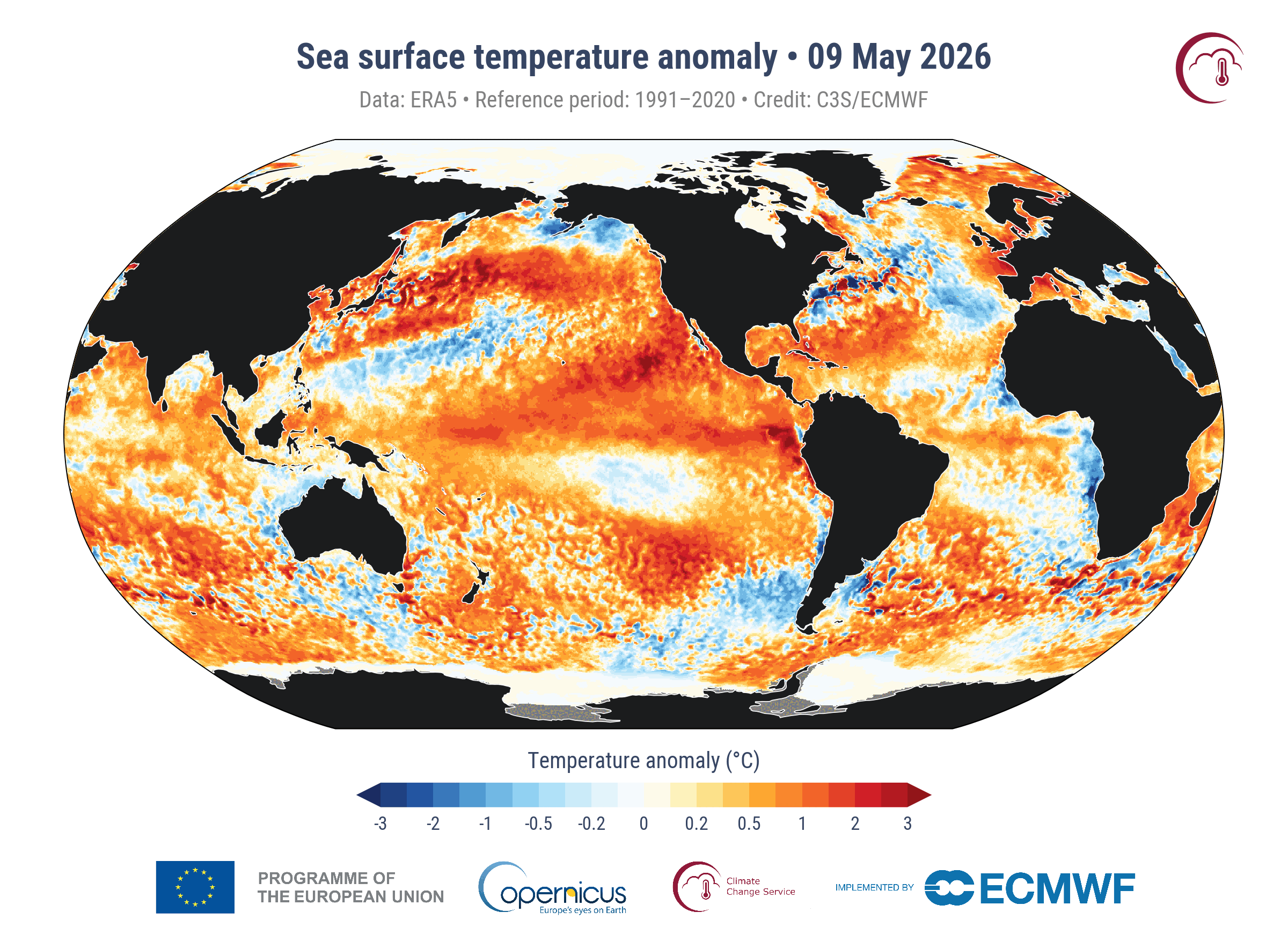
Image: Sea surface temperature anomalies on May 9, 2026, showing above average water across much of the tropical Pacific Ocean, indicating an emerging El Niño pattern. Source: CS3 / ECMWF.
How does ENSO affect weather and climate?
ENSO results in a range of teleconnections (knock-on weather effects) across different regions of the world, from enhanced monsoons or droughts to higher/lower seasonal temperatures. During El Niño, notable teleconnections include:
- Drier conditions in Australia, Indonesia and southern Africa, which can lead to droughts and wildfires
- A weaker monsoon season in India
- Wetter conditions in western South America, southern USA and eastern Africa, leading to increased risks of flooding
- Usually, a warmer than average year globally.
During La Niña, the opposite teleconnections mentioned above can occur.
ENSO impacts in Europe
In Europe, the effects of ENSO are generally less pronounced than in other areas of the world. This is partially due to the large distance between Europe and the Pacific Ocean. As well as this, the weather in Europe is primarily controlled by the North Atlantic Oscillation (NAO), which can mask the effects ENSO may have had on the climate. However, depending on the strength of the El Niño, the teleconnections can become more evident.
During summer under El Niño, the UK and northern Europe generally experience a drier and warmer season as a result of the jet stream shifting northwards and supressing rainfall to the south of it. At the same time, southern Europe tends to see a wetter summer due to enhanced convective rainfall under a more subtropical flow.
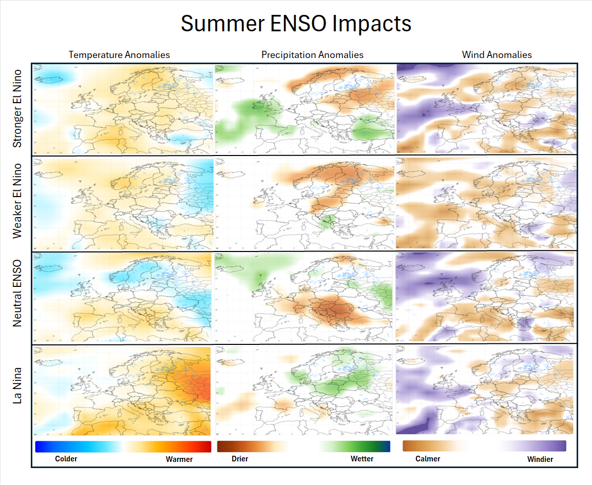
Image: Summer ENSO impacts in Europe. Source: DTN.
Wintertime in Europe under El Niño is more complicated and sees significantly different impacts based on the strength of the El Niño.
A moderate El Niño (defined as SSTs +1.0 to +1.5 °C higher than average in the tropical Pacific) increases the likelihood of a disruption of the polar vortex, which can lead to a higher risk of cold and wintry conditions across western Europe.
However, a strong, or ‘super’, El Niño (defined as SSTs +2.0 °C higher than average in the Pacific) tends to enhance the jet stream above the North Atlantic, steering storm systems directly into the UK and western Europe. Additionally, a strong El Niño generally supports the polar vortex, meaning it is less susceptible to disruption and reducing the likelihood of colder air making its way to the UK. So, the result is a milder than average, wet and stormy winter, with an active Atlantic storm track.
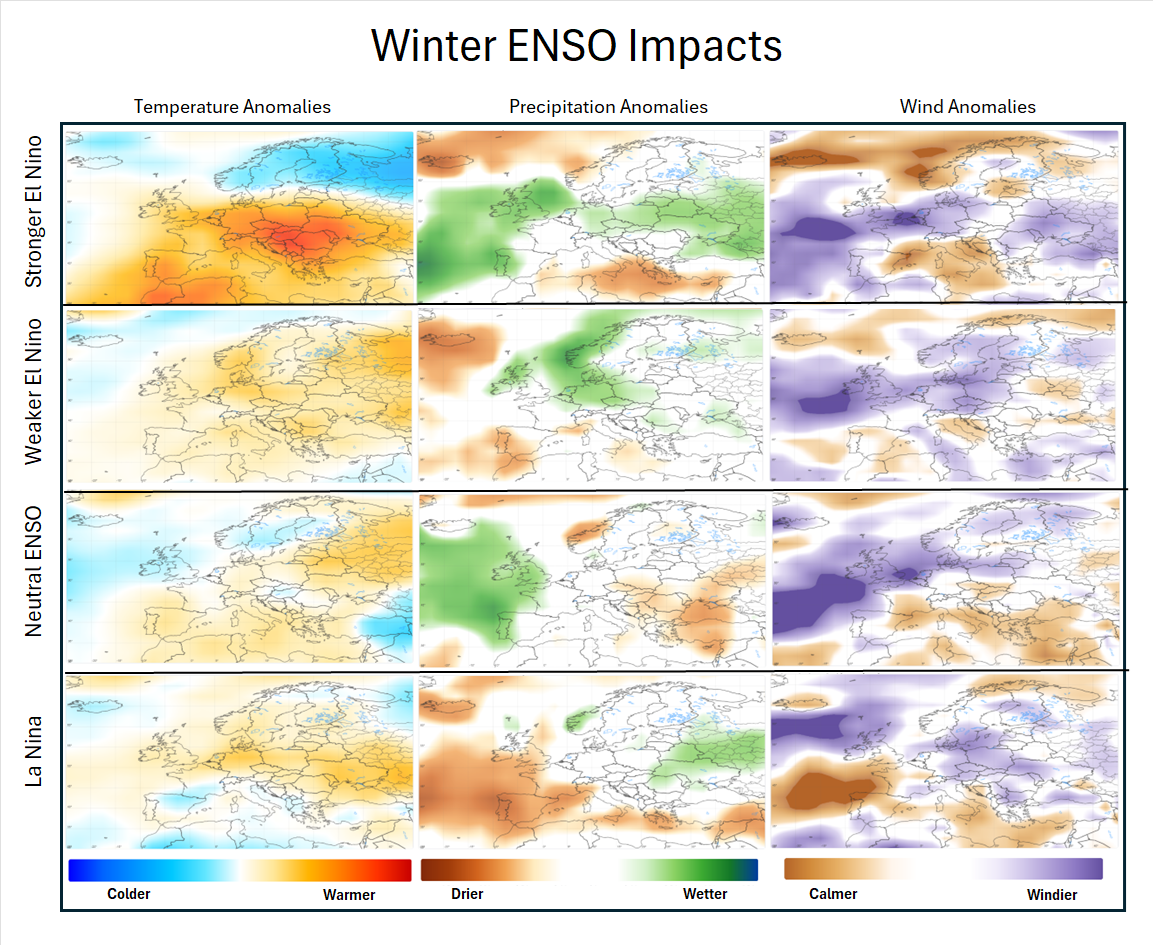
Image: Winter ENSO impacts in Europe. Source: DTN.
Will we see El Niño this year?
At present, forecasters from the USA’s National Weather Service suggest there is a 61% chance of El Niño emerging this year within May to July, continuing through to at least the end of 2026.
Forecasters also believe this emerging El Niño could be strong, so the UK can expect potentially drier and warmer conditions over the summer, followed by a stormier and milder end to the year.
During the next few months, monitoring of the Pacific Ocean’s SSTs is vital to determine whether we will enter an El Niño phase this year, helping different areas of the globe better prepare for potential extreme weather.
ENSO in a changing climate
Climate scientists are also considering how current conditions and climate patterns will be affected in the future as the planet’s climate warms.
ENSO itself is expected to strengthen due to climate change, though climate models also indicate a strengthening in the ENSO European teleconnections. This means that, despite currently seeing few shifts in the weather patterns due to ENSO in Europe, the future may bring more variable weather across the continent, contributing to the increase in extreme weather we will all likely experience across Earth under a warming climate.