
Eastern Canada bracing for wild weather as 'bomb cyclone' looms
Strong winds, heavy rain and large waves will impact parts of Eastern Canada this week as a pair of low pressure systems rapidly intensify off the coast.
Explosive Cyclogenesis
Although hurricanes deservedly grab headlines, extra-tropical cyclones can sneak under the radar. These are simply low pressure circulations that develop outside of the tropics, in the mid-latitudes, but which can still cause dangerous weather.
Extra-tropical cyclones are particularly notable when they undergo rapid deepening, known as ‘explosive cyclogenesis’. You may also hear the terms ‘bomb cyclone’ and ‘bombogenesis’, but these all refer to a low pressure system with a central pressure that has dropped rapidly over a 24-hour period.
The threshold for explosive cyclogenesis differs depending on latitude:
- At 60 degrees, explosive cyclogenesis refers to a pressure drop of 24 hPa in 24 hours.
- At 50 degrees, the threshold for explosive cyclogenesis is about 21 hPa
- At 40 degrees, a pressure drop of 18 hPa in 24 hours qualifies as explosive cyclogenesis.
This week’s Maritimes storm
One such low pressure system is likely to swipe the Canadian Maritimes on Tuesday, November 4.
A circulation near the Mid-Atlantic coast will undergo rapid intensification as it tracks northeast toward the Maritimes, with its central pressure falling from 1005 hPa to about 945 hPa in just one day - an extraordinary drop of 60hPa. This is around three times the required threshold for explosive cyclogenesis at this latitude.
The images below show the rapid intensification of the low over a 24 hour period from Monday night to Tuesday night.
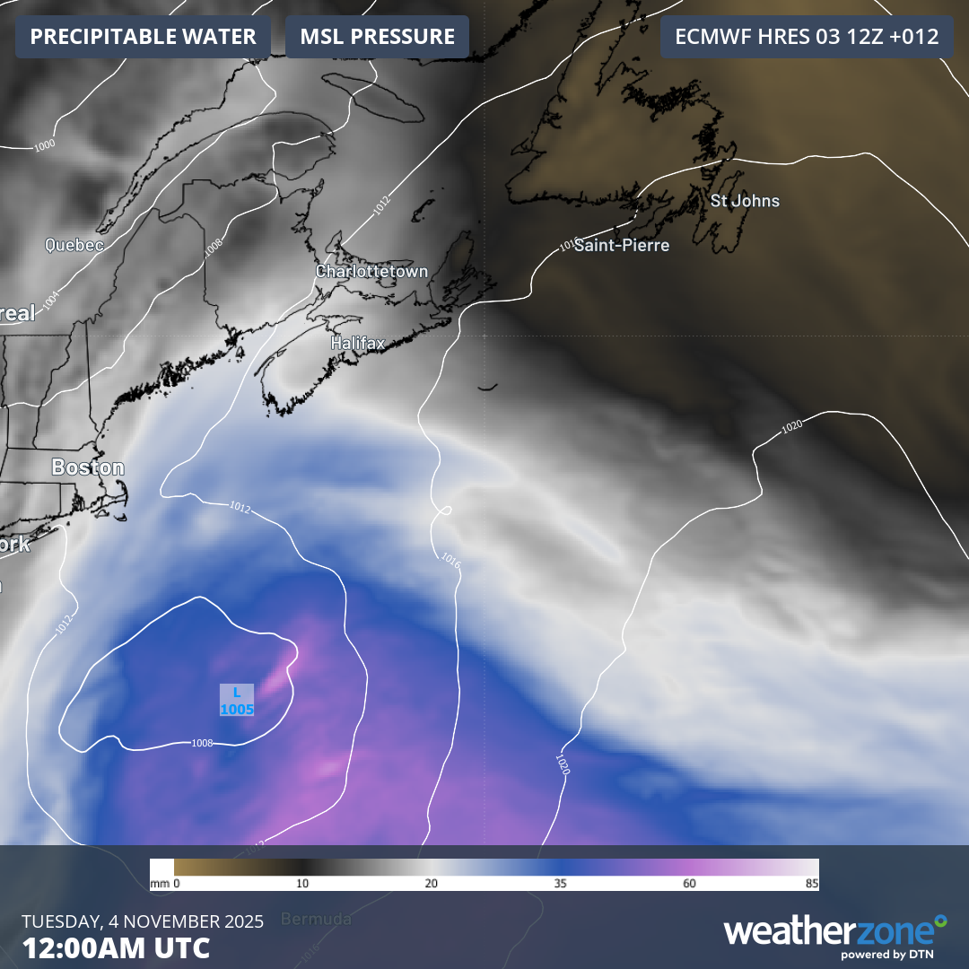
Image: Mean sea level pressure and precipitable water at 12:00am UTC on Tuesday, November 4 (8:00 pm AST on Monday, November 3).
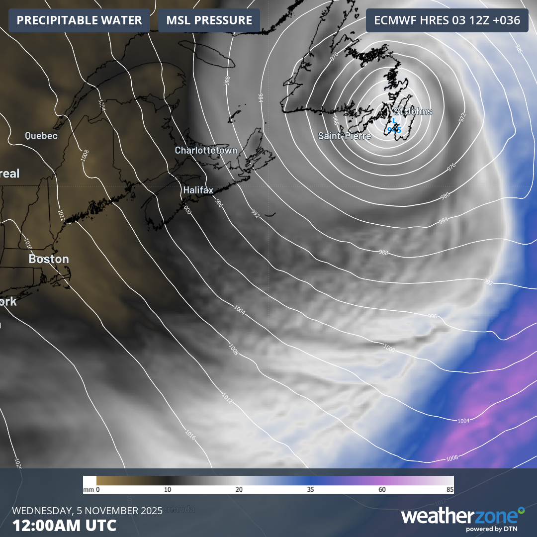
Image: Mean sea level pressure and precipitable water at 12:00am UTC on Wednesday, November 5 (8:00 pm AST on Tuesday, November 4).
The intense low is forecast to pass near Newfoundland between Tuesday afternoon and Wednesday, generating disruptively strong winds and heavy rain.
Gusts in excess of 50 mph (80km/h) are expected widely and could get above 70 mph (113 km/h) in exposed coastal locations, while rainfall totals of 2-4 inches (50-100 mm) are possible, especially near Cape Breton. Some coastal flooding could occur from over-topping seas, with inshore waves potentially between 10-20 feet (3-6 meters).
Moreover, another quickly deepening system could follow on Wednesday night and Thursday – this time a clipper system from the west-northwest.
How does ‘bombogenesis’ occur?
Not all low pressure systems intensify so quickly, so what factors feature in explosive cyclogenesis?
The first key ingredient is area of high baroclinicity – a large change in temperature over a relatively short horizontal distance, such as along a cold front. This can also be associated with a powerful jet stream and an upper-level trough, which provide upper-level support for the surface-based low pressure system to intensify.
Under the right setup, air moving away (divergence) at the top of the air column becomes much greater than the air moving in (convergence) near the surface, which causes the column of air to lose mass and the surface pressure quickly drops.
The contrast of relatively warm water with the first few wintry air masses and a strong jet stream explains why explosively deepening storm systems are most often seen during the fall, especially over the oceans.
Environment Canada has issued warnings for rainfall, wind and coastal flooding in parts of Eastern Canada. Check the latest warnings for the most up-to-date information on this event as it unfolds.