
Early-November lake effect snow wrap-up
Bands of lake effect snow blanketed parts of Illinois, Wisconsin and Indiana earlier this month, including bouts of early-season snow in parts of Chicago and Milwaukee.
When snow began to fall late in the day on Sunday, November 9, some parts of the Chicagoland area were bracing for totals between 10-12 inches, with others hoping it would drift away from them. As the system progressed on Sunday night into Monday morning, two distinct bands of snow formed off Lake Michigan.
Timeline of the snow
At 8pm CST on Sunday, snow was already falling over much of southern Wisconsin into northeastern Illinois/Chicago and surrounding areas into Northwest Indiana.
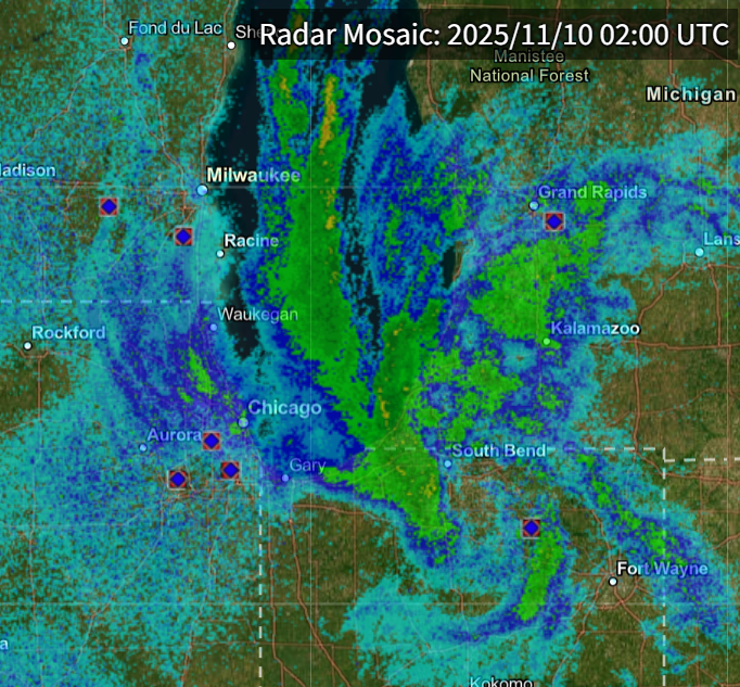
Image: Radar showing precipitation around southern Lake Michigan at 8pm CST on Sunday, November 9. Source: NCEI / NOAA
By 2am CST central on Monday, the snow bands began to split, forming into two distinct heavy bands over portions of southern Wisconsin into Lake and northern Cook Counties in Illinois into McHenry County and another area of Lake, Porter and La Porte Counties in Indiana.
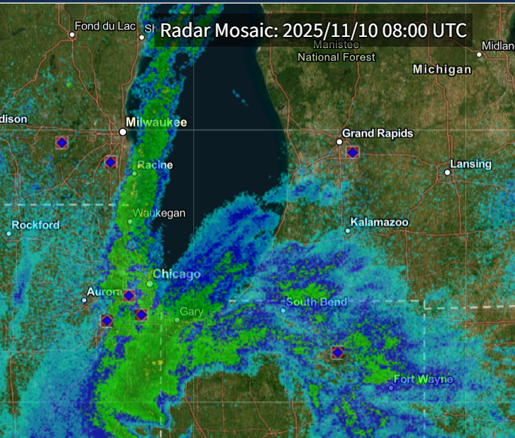
Image: Radar showing precipitation around southern Lake Michigan at 2am CST on Monday, November 10. Source: NCEI / NOAA
Between 5-6am CST, snow started to diminish over portions of northwestern Indiana, with the other lake effect band continuing over Lake County in Illinois, moving slowly southward into portions of northern to central Cook County.
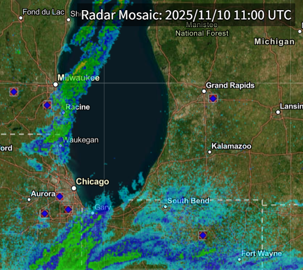
Image: Radar showing precipitation around southern Lake Michigan at 5am CST on Monday, November 10. Source: NCEI / NOAA
Snow continued to move through Cook County before swinging through northwest Indiana once more during the afternoon as the wind direction changed to more northerly then northwesterly off the lake. Snow seemed to diminish completely over the area by 6-7pm CST, with some remaining snow falling over portions of northeastern Indiana.
How much snow fell?
For Chicago, snow totals between 1-3 inches were observed, with snow amounts in portions of southern Wisconsin and northern Illinois between 6-11 inches.
Into southern Cook County, IL and through Northwest Indiana, snow totals between 10-13 inches were observed, with some of the highest reports coming from Valparaiso and Cedar Lake, Indiana.
Because of the wind shift to the northwest later in the day, areas around South Bend Indiana reported between 8-12 inches of snow, with some areas of southwestern Michigan reporting between 1-3 inches.
Was this even unusual?
Overall, lake effect snow is not unheard of for this region, with South Bend being a main target for lake effect snow during the late-fall into winter. For places like downtown Milwaukee and Chicago, only specific conditions tend to shift the winds to get this type of lake effect snow event over the region.
This system caused backups during the morning commute as the snow caused white-out conditions over some of the major highways in the area, with reports of multiple accidents and even some vehicles stuck within the snow.
This storm is the earliest a Winter Storm Warning has been issued by the Chicago National Weather Service for the area, giving them a brief look at how winter could look in the coming months.