
Early December to bring unsettled conditions in the UK
Although winter started, meteorologically-speaking, on December 1, there is no major cold outbreak in sight for at least the next couple of weeks. Instead, there should be a continuation of the unsettled conditions the UK has been experiencing over the last few days.
The larger-scale reason behind the unsettled conditions is an active jet stream across the North Atlantic region. The jet stream is a relatively narrow corridor of strong winds several miles up in the atmosphere and typically forms along the boundary of warmer air from tropical regions and colder air from the polar regions. When this temperature contrast is more pronounced, the jet stream is typically stronger and more active.
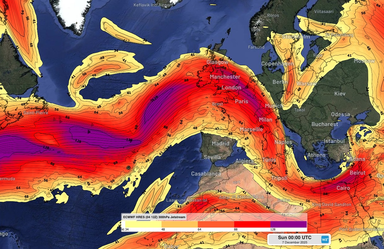
Image: Modelled jet stream winds over the North Atlantic and Europe on Sunday, December 7, 2025. Source: Weatherzone.
Lower down, small ripples along the temperature contrast zone – the polar front – can be enhanced by the jet stream and evolve into large areas of low pressure. These ‘mid-latitude’ storm systems are often hundreds of miles across, and sometimes their effects can be spread over a diameter greater than a thousand miles.
Over North America, repeated surges of frigid Arctic air will affect much of central and eastern Canada over the coming days, as well as a large part of the north, central, and eastern United States.
As these waves of cold air move out across the western part of the North Atlantic Ocean, they will strengthen the temperature contrast in that region and promote a powerful jet stream.
Repeated development of areas of low pressure will be the result, and these will bring bouts of wind and rain to the UK over the next week or two, at least.
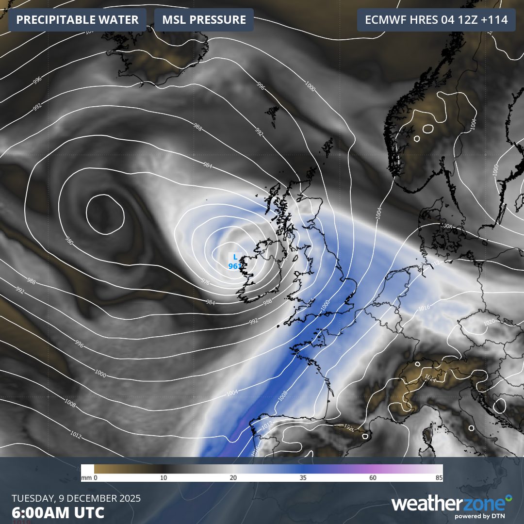
Image: Modelled mean sea level pressure and precipitable water at 0600 UTC on Tuesday, December 9, 2025. Source: Weatherzone.
Through the upcoming period, the wind will frequently blow from the south-west across the UK. This will result in strong positive temperature anomalies: temperatures should be between 2 and 6 Celsius above the long-term mean over the coming week or two, with the largest anomalies across England and Wales.
The geography of the UK can lead to dramatic variations in rainfall amounts over relatively small distances. Higher ground can enhance rainfall amounts as the moist air is forced to rise by the terrain.
In the upcoming period, western and southern parts of the UK will see much larger rainfall totals than locations to the north and east of higher ground. For example, parts of western Scotland are likely to receive over 100 mm of rain over the next week, whereas areas around the Moray Firth are expected to have fewer than 15mm in the same period.
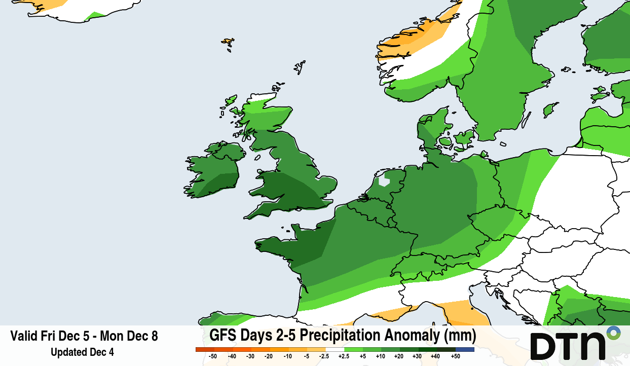
Image: Forecast precipitation anomalies for the four-day period from Friday, December 5 to Monday, December 8. Source: DTN.
So, what about Christmas and the elusive snowfall which Dickensian scenes on seasonal greetings cards depict?
The current unsettled and broadly mild spell looks like continuing past mid-month, with no real signals of any deep, cold airmasses. There are one or two hints of the pattern becoming somewhat less active as the festive season approaches, which could give colder airmasses at least a chance of moving in, but don’t dust off the sledges just yet.