
Destructive winds imminent as Cyclone Narelle approaches WA
The destructive wind field surrounding Severe Tropical Cyclone Narelle will start impacting Western Australia’s Pilbara district today, beginning a prolonged period of violent weather that will last for more than 24 hours and extend over 800 km across northwestern Australia.
At 5am AWST on Thursday, March 26, Severe Tropical Cyclone Narelle was a category 3 system located around 240 km to the north of Karratha. At that time, sustained wind speeds near Narelle’s core were estimated to be reaching about 155 km/h, with peak gusts around 220 km/h.
Narelle is a big tropical cyclone with an unusually large destructive wind field. Early on Thursday morning, when the system’s centre was located about 250 km off the WA coast, Narelle’s destructive wind field (wind gusts above 125 km/h) was extending around 200 km to the southeast of its core. The more powerful very destructive wind field (wind gusts exceeding 165 km/h) extended about 50 to 60km from Narelle’s core.
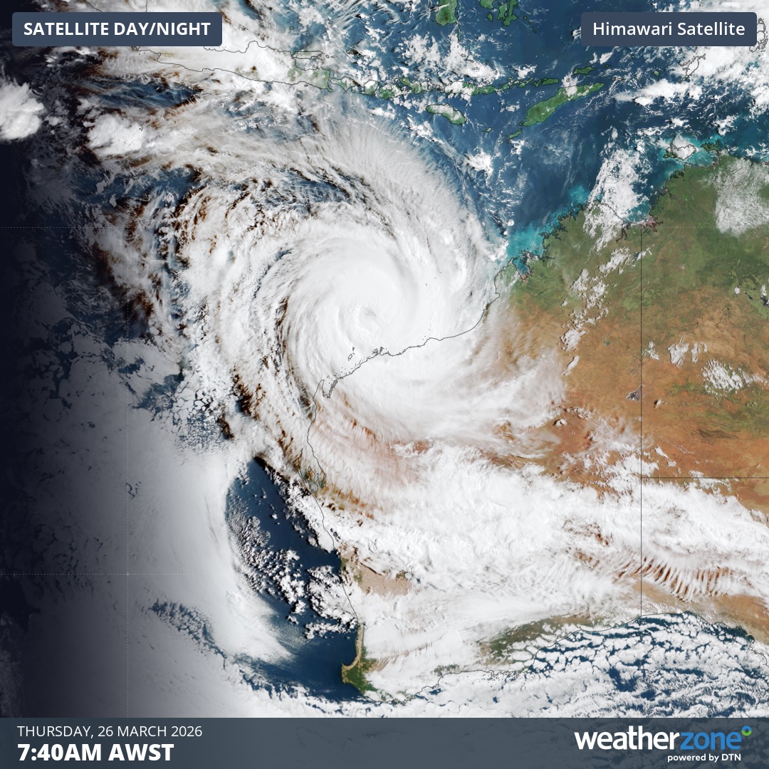
Image: Visible satellite image showing Severe Tropical Cyclone Narelle to the north of WA on Thursday, March 26, 2026. Source: Weatherzone.
Narelle forecast to intensify further
Severe Tropical Cyclone Narelle is located in an environment that will allow it to strengthen further on Thursday into Friday morning. The latest forecast track map from the Bureau of Meteorology, issued at 5:46 am AWST on Thursday, predicts that Narelle will peak in strength as a high-end category 4 system on Friday morning. However, it may undergo rapid intensification and become a category 5 system by Friday morning.
As Narelle gains strength, it will move in a southwesterly direction that will allow it to gradually get closer to the Pilbara coast during Thursday and Friday morning. The system should then turn towards the south and make landfall over the Gascoyne coast late on Friday or early Saturday, most likely as a category 3 system. The approach angle of Narelle will be roughly parallel to the Gascoyne coast, which will cause a gradual landfall and prolong its impacts.
The combination of Narelle increasing strength while gradually approaching land, followed by a protracted landfall, will expose a large area of WA’s Pilbara and Gascoyne districts to Narelle’s violent weather. This will include very destructive winds, heavy rain, large waves, abnormally high tides and coastal inundation.
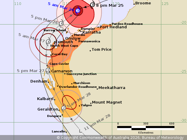
Image: Forecast track map issued by the Bureau of Meteorology at 5:46 am AWST on Thursday, March 26, 2026. Source: Bureau of Meteorology.
According to the Bureau, “destructive wind gusts in excess of 125 km/h may occur on the Pilbara coast near Karratha during Thursday morning, extending west to Exmouth during Thursday, and south to Carnarvon and then to Denham and the Overlander Roadhouse during Friday.”
The more powerful winds closer to Narelle’s core could start to impact the WA coast by Thursday night.
The Bureau says “very destructive wind gusts up to 275 km/h may develop west of Onslow later on Thursday as Narelle moves closer to the North West Cape. Carnarvon could see wind gusts up to 220 km/h during Friday, and wind gusts up to 195 km/h could extend to Denham late Friday or early Saturday.”
Heavy rain is also expected over western parts of the Pilbara and Gascoyne districts on Thursday and Friday, which is likely to cause flash flooding.
A dangerous storm tide accompanied by damaging waves will also develop between about Onslow and Denham as Narelle tracks further south over the next two days. This is likely to cause flooding in low-lying coastal areas.
Forecast details may change over the next 24 to 48 hours as Severe Tropical Cyclone Narelle continues to evolve. Check the latest tropical cyclone advisories and warnings for the most up to date information.