
Derecho leaves trail of destruction across Midwest U.S.
A line of violent winds and severe thunderstorms swept across the Midwestern United States on Monday afternoon, causing significant damage and prompting a rare alert for a meteotsunami in Lake Michigan.
Monday's destructive windstorm is a phenomenon known locally as a derecho. Unlike tornadoes, which cause violent rotating winds, derechos are a fast-moving elongated arc of straight-line winds and thunderstorms that affect a much broader area than a single tornado.
Derechos form when cold air flowing out of a collapsing thunderstorm produces a new line of thunderstorms that travel away from the original storm cell. Under the right atmospheric conditions, this new storm complex will continue to grow and multiply, eventually becoming a self-sustaining line of powerful wind and thunderstorms that can progress for hundreds of kilometres in a straight line.
To be classified as a derecho, the windstorm needs to:
- Produce a swathe of wind damage that extends for more than 250 miles (about 400 kilometres)
- include wind gusts of at least 58 mph (93 km/h) along most of its length
- include several, well-separated 75 mph (121 km/h) or greater gusts
Monday's derecho swept from west to east across parts of Iowa, Wisconsin, and Illinois, prompting warnings for destructive winds, severe thunderstorms, and tornadoes. There was even an alert put out for the possibility of a meteotsunami as the derecho crossed Lake Michigan. A meteotsunami is a relatively rapid (tens of minutes) fluctuation in water levels caused by a sudden change in atmospheric pressure. These rare events can cause sudden and unexpected flooding in low-lying coastal areas.
545 PM update: Now would be a great time to LEAVE the beach and especially get off the piers, as lightning, high winds and the potential for a meteotsunami is rapidly approaching from Grand Haven to South Haven! #miwx #wmiwx pic.twitter.com/TrSFj5z30F
— NWS Grand Rapids (@NWSGrandRapids) August 10, 2020
With the U.S. being one of the most comprehensively observed land-masses in the world from a weather perspective, this derecho event was captured in amazing detail.
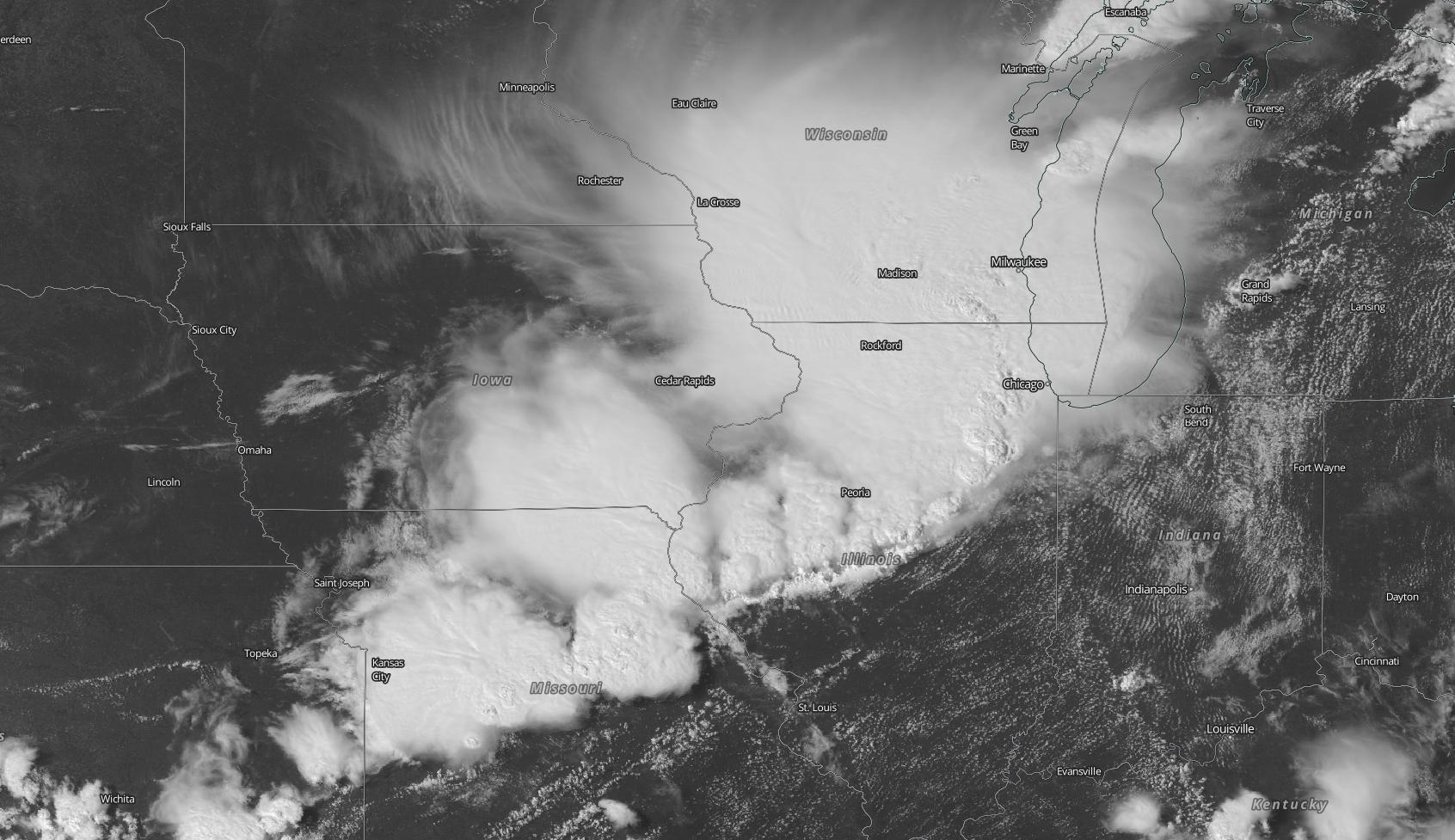
Image: Visible satellite image captured by the GOES-East satellite at 2040Z on Monday. Source: NASA Worldview
High-resolution images from the GOES-East satellite revealed the impressive size of the derecho as it roared across the Midwest on Monday. Lightning satellite and land-based lightning sensors showed how persistent and widespread the thunderstorms were along the wind front. Radar towers witnessed the intensity of rain and wind along the destructive derecho. During and after the event, social media was also flooded with images and videos of snapped trees, flipped trucks, and even house walls and car windows impaled with wooden beams.
Roof blew off Floor to Ceiling store and hit beauty parlor in Ottawa pic.twitter.com/EAoKZCbSYX
— Tammie Sloup (@TT_tsloup) August 10, 2020
2x4s punctured through a home in Perry 😳 #iawx
— Taylor Kanost (@WxKanost) August 10, 2020
📸: Jennifer Pickering pic.twitter.com/IgjgMcw99K
The #derecho has arrived.
— Nate Tubbs (@nptubbs) August 10, 2020
It went from stillness to raging storm in minutes, branches and trees downed all over.#TheIsland #Chicago pic.twitter.com/t2bfmVfJzs
According to local meteorologists, wind gusts were recorded up to 180km/h during this event. There was also a small but detectable meteotsunami, with the water level along the coast of Michigan falling by around 30cm in one hour before quickly rising again.
According to Northern Illinois University meteorology professor Victor Gensini, who spoke to the Washington Post, this is likely to go down as one of the strongest derechos in recent history and could be one of the worst weather events of 2020 for the U.S.